Sheep Canyon January 2014

This was our first time off-roading in the desert in our Toyota Corolla, so it was a pleasant surprise when we found that it handled the dirt roads amazingly well. Of course, it doesn’t have a lot of clearance, but I took a good look at the undercarriage to see where the vulnerable points were before we left, so I felt confident that we would avoid any major rock damage. Careful and slow driving (when warranted, where there is a profusion of rocks and declivities on the road) are the key to taking a passenger car safely into the desert.

We drove north out of Borrego Springs on DiGiorgio Road until the pavement ended and it became Coyote Canyon Road. This continued up Coyote Canyon for several miles. Amazingly, we were able to get the car beyond Third Crossing (we crossed the flowing Coyote Creek three times) which was a feat only my truck had done before. We were well-satisfied!

Our goal: To explore the South Fork of Sheep Canyon!

A large chockstone at the headwall above the palm grove in the South Fork of Sheep Canyon

Click on the photo to read the complete Trip Report


Wind Caves Nov 2012

Our friend Michela let it be known that she wanted to get into backpacking by asking me for advice on gear and where to go hiking. Well, gear advice is easy enough to make, so I made some. And then I offered to take her (and a guest) backpacking with Vicki and me, for training purposes (and for fun!).

If there’s one thing that I’ve learned over the years, it’s that it is very important that your friend have a good time on their first backpacking trip. You want good weather, a beautiful location, a relatively short hike with minimal elevation gain, tasty food, and pleasant company. In other words, the new hiker should have a great time. If they don’t, then they’ll never go backpacking again. It’s better to save that miserable rainy weekend when your tent blows down, your clothes are all wet, and the fire won’t light for another trip. Wait until they are addicted to backpacking before you try anything difficult. A tough hike that seems like a terrible ordeal while it’s happening can become a great story to tell afterward. But don’t try it with a newbie.

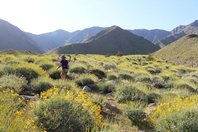
Now, when you’ve never been backpacking the choices of where to hike seem endlessly daunting. Luckily, at this time of year our choices had been limited by weather: It was freezing cold at night up in the mountains, especially at the higher elevations. So the obvious choice, if you live in Southern California, is the desert. And, since the Thanksgiving holiday weekend is the traditional start of Desert Season, we decided to join the rest of the off-roaders heading to Anza-Borrego Desert State Park. But still we were left with the question: Where exactly would we go? It’s a very big park. But the park is also mostly about driving. Off-road driving. Hiking in the park is only for when the path gets too narrow to drive on it. In fact, backpacking isn’t big in the desert, as water sources are rare, and you can only carry so much of it. Therefore, Vicki and I decided that a good backpacking trip for a newbie (and her guest) would be to go to the Wind Caves.

Sunset Silhouettes at the Wind Caves in Anza-Borrego Desert State Park

Click on the photo to read the complete Trip Report


Sheep Canyon January 2012

We took advantage of some mild weather to explore Sheep Canyon in Anza-Borrego Desert State Park. We drove our old truck northwest out of Borrego Springs into the desert about as far as we could drive it on Coyote Canyon Road (a dirt road), to a point just beyond Third Crossing. We took the truck because there were six of us on this trip and all of us and our gear fit inside nicely (we never could have fit all of them, even without backpacks, in our old Saturn).

After that, we backpacked out to Sheep Canyon for two relaxing nights in the Desert!

Lots of nice quiet pools in Sheep Canyon in the Anza-Borrego Desert

Click on the photo to read the complete Trip Report


Granite Mountain Nov 2011

We did a Thanksgiving weekend bushwhack hike up Granite Mountain in Anza-Borrego Desert State Park. Like fools, we decided to try a “new” route, not listed in the usual places on the internet, such as summitpost. The “standard route” as reported on SP is the same route that the late Jerry Schad listed in his guidebook, “Afoot and Afield in San Diego County.” This is also the route that the Sierra Club consistently uses as it escorts its members up the mountain via guided tour. In fact, nearly all the websites that I searched blatantly plagiarized Schad’s original description of the route. For shame! We would have none of that. There would be no tame, well-trodden, so-called “bushwhacks” for us. We’d try another route to the summit, even if it took us all day. And it did! Not that we wanted it to…

Yucca- and cholla-whacking the northeast ridge of Granite Mountain

Click on the photo to read the complete Trip Report


Indian Canyon March 2011

Vicki and I headed out to Anza-Borrego Friday evening after work, arriving about ten o’clock. We drove out on Coyote Creek Road until just before the Third Crossing, which was about a mile further than we’d ever driven before. We decided last time that the car should be able to make it over this one tricky section of road, and it did! We parked in the dark, and got out into the gusty, windy night. There was a wildly flapping tent set up behind a parked truck, and we knew they had to have heard us pull up, as there wasn’t much sleeping to be done in a tent with the wind blowing it nearly flat. We packed up as quickly as we could, donned our headlamps, and hiked out. We both wore our rain gear as windproofing, and Vicki also put a bandanna over her mouth and nose for protection from the flying dust.

Looking up into the Valley of the Thousand Springs

Click on the photo to read the complete Trip Report


Cougar Canyon Jan 2011

We left San Diego for Anza-Borrego on Friday evening about 7:30pm, about two hours after I got home from work, which was the fastest I could go. Yes, we knew that it would be dark when we got there, but we didn’t care; we had a plan, and we were going to squeeze in two nights of camping no matter what.

Our plan was to spend Saturday exploring Cougar Canyon, the mouth of which was about five miles from the nearest spot that we could drive our car. That pretty much made it mandatory that we backpack the entire five miles on Friday night, camp that night, explore the canyon all the next day, sleep in the same campsite again, then backpack out on Sunday morning. And that’s what we did.

HDR shot of a Cougar Canyon Waterfall

Click on the photo to read the complete Trip Report


Goat Canyon Trestle Nov 2010

We went out to Anza-Borrego to get in a night of camping, because we’d been too long in civilization. It was time to rough it a bit, and we needed to do some hiking, to burn off that Thanksgiving dinner. Also, Thanksgiving Weekend is the traditional start of “Desert Season” and we wanted to get out there as often as possible, now that the temperatures were cooler.

We headed east out of San Diego to the southern end of Anza-Borrego Desert State Park, intending to hike along the old Carrizo Gorge Railway to see the Goat Canyon Trestle, one of the largest wooden railroad trestles. It should be noted that we attempted this earlier in the year, by trying to hike from Mortero Palms over the top of the Jacumba Mountains and down Goat Canyon, but we ended up turning around without descending the canyon. Sure, we saw the trestle from way up above it, but seeing it isn’t the same as walking across it, and looking straight down 200 feet through the steel catwalks alongside the tracks. This time we’d do it right. But by a different route, hiking directly along the tracks.

HDR shot of the sunrise on the tracks at the end of Dos Cabezas Road

Click on the photo to read the complete Trip Report


Coyote Creek March 2010

Summary: We backpacked to Middle Willows on Coyote Creek. We started hiking from our car, which was parked as far as we could drive it on Coyote Canyon Road, hiking through the Lower Willows Trail, then up the long series of washes that Coyote Creek has made through the Collins Valley. It was very windy that first day. We found water at Middle Willows and camped overnight in the lee of a hill. The next day we hiked out along the four wheel drive road back to the car.

Click on the photo to read the complete Trip Report