We did a Thanksgiving weekend bushwhack hike up Granite Mountain in Anza-Borrego Desert State Park. Like fools, we decided to try a “new” route, not listed in the usual places on the internet, such as summitpost. The “standard route” as reported on SP is the same route that the late Jerry Schad listed in his guidebook, “Afoot and Afield in San Diego County.” This is also the route that the Sierra Club consistently uses as it escorts its members up the mountain via guided tour. In fact, nearly all the websites that I searched blatantly plagiarized Schad’s original description of the route. For shame! We would have none of that. There would be no tame, well-trodden, so-called “bushwhacks” for us. We’d try another route to the summit, even if it took us all day. And it did! Not that we wanted it to…
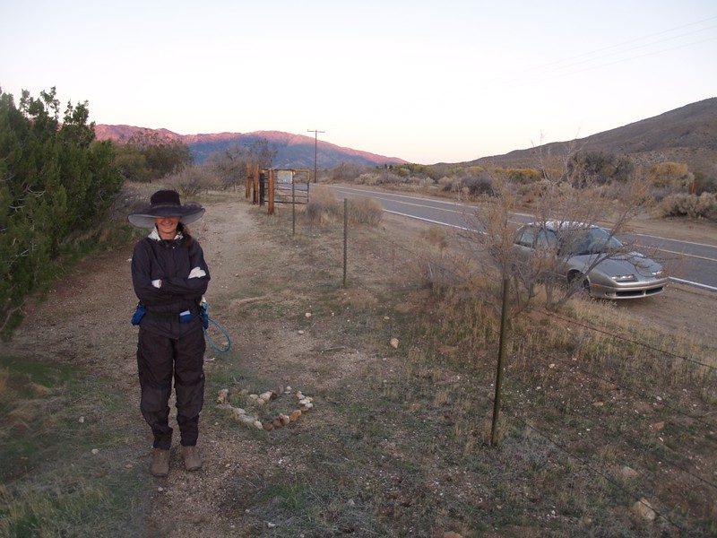
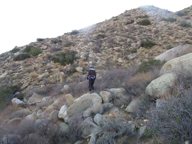
We arrived at the PCT trailhead near Scissors Crossing (junction of CA Route 78 and S22) precisely at dawn, and hiked south toward Granite Mountain. This was easy hiking on the valley floor for 2 miles. It was cold out, and there was frost. When the PCT turned right to climb along the side of the mountain, we continued onward, directly up a cleft toward the top of the northeast ridge. The vegetation was thicker down in the cleft, so we headed more directly toward the top even though it was steeper. We were still in the cool shade, but it was hot while climbing.

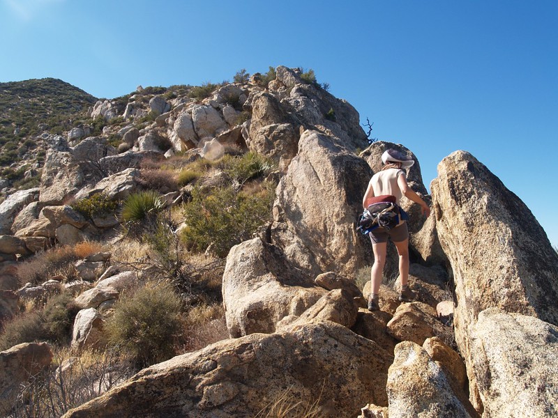
Once we were on the ridge the brush was easier. And there was much less of it on the southern side of the ridge. It was standard desert stuff: Yucca, various cacti, and sparse grasses. The ridgetop absorbed less rain and the southern side received more sun; this meant less brush. Those lovely dried grasses were deceptively appealing for walking, but they, too, were armed as was everything else out here. They were a variety of Foxtail Grass, which had seeds like one-way velcro arrows. Its official name is Alopecurus, but my name for this stuff is “Evil Bad Grass” – Why? Because it is! The one-way arrows of its seeds insidiously work their way deeper and deeper into your socks until they stab you with each flex of your ankles. A LOT of time was spent clearing and re-clearing our socks and shoes of this evil stuff. In other words, the evolutionary adaptation of this grass was excellent for spreading its seed, as we (its hapless tools) deposited the evil seeds far, far from the original plants.


The air was cool but the sun was warm, so it was nice hiking weather. We continued slowly up the ridge, picking our way amongst the plants. Some sections of the ridge were rocky, with large boulders, and it was fun to scramble up them. When we stopped for rests it was cold, so we tried not to stop for long. Besides, we were running much slower than anticipated. This was not an easy bushwhacking route, even though it looks easy in the pictures.

There were several “bumps” and saddles on the way up the ridge, and on the last two uphill grades the brush became much thicker. We had to shove and stomp and power our way through some of the brush. It was getting exasperating, as we were so close to the top. But Granite Mountain is 5633 feet tall, and is still able to collect a decent amount of rainfall each year, even if it is in the rain shadow of other mountains to the west, and as such it grew a healthy crop of bushes on top. (We saw only a few small pine trees, and only in protected locations.)


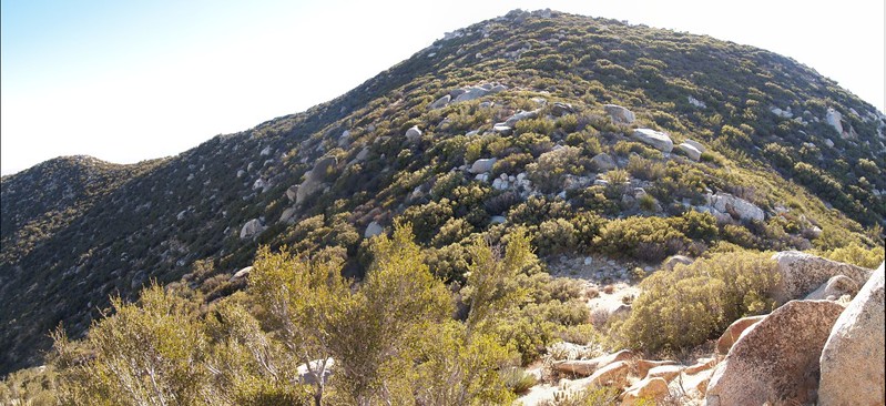
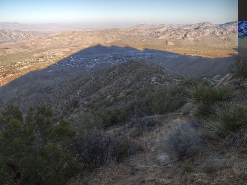
The summit, once we reached it, was really nice. Excellent views in all directions. Theoretically, we could see San Gorgonio Mountain, over 75 miles away, and maybe we did, as it was blended in with Jean Peak and San Jacinto Peak in the distant north. Santa Rosa Mountain, Toro Peak, Rabbit Peak, and Villager Peak were plain to see to the northeast, with the afternoon sun shining upon them. It was cool and breezy up on top, so we put on our wind-proof layer. I signed the register and took a bunch of pictures.


We discovered that the western side of the peak had burned not long before. There were no bushes whatsoever on that side! Now, I’m not a big fan of forest fires, but I admit that I was thinking, while looking at all the bare ground and those tiny charred stubs of bushes, “Why did the fire have to stop right at the peak? Why couldn’t it have continued burning just a half-mile further down the ridge we’d just killed ourselves bushwhacking? Why?” But some questions shouldn’t be voiced, let alone answered. We also found a lot of caked-on fire retardant up there, just beneath the summit block, bright orange dried-on crud all over the place. Anyway, the fire stopped right there, so the stuff must work…


But all was not rosy, even though we were on top of a mountain. It turned out that we reached the summit just past two PM, after nearly eight hours of hiking. We were WAY beyond our official turn-around-time, which we’d decided (at 6:30 that morning) should be about noon, or one PM at the absolute latest. The problem was all those bushes! (Maybe this is why they call it bushwhacking.) The summit looked so close, so we didn’t want to quit while it was practically within our grasp, and yet it took us another hour or more to cover the last half mile up that final slope. And so we overshot our turn-around time. Well, we knew what was going to happen, and we were prepared for it, with an extra outer layer of clothes, plenty of water, my trusty GPS, and headlamps with fresh batteries. We resigned ourselves to hiking the last bit in the dark. What we were hoping to do, however, was to get down off the trail-less mountain and back onto the easy-to-follow PCT before it was completely and utterly dark. And, as we all know, “hope” is a wonderful thing, but it doesn’t stop the sun from setting.

We also decided to try to follow the ducks (cairns) on the way down that initial brush-laden slope. We noticed on the way up that there were occasional ducks that previous hiker(s) had left to show the way. For the most part we ignored them, because all we had to do was follow the ridge up to the top, and we didn’t really need little stone piles marking the way; either we were on the ridge or we weren’t. But on the last stretch they turned out to be quite useful, as someone had chopped some of the brush, and the route was easy to walk on. But it was also easy to lose track of this faint path. Still, we decided in the end that it was well-worth the time to back-track and find those ducks. And we made pretty decent time down the ridge, partly thanks to the ducks, and partly because it was downhill. Nonetheless, the sun was setting rapidly.

We hustled along the ridge in the dim light as long as we could. Eventually, it began to get much darker, so we broke out the headlamps. While there was still the tiniest bit of light left, we decided, after looking at the topo map on the GPS, that it might be a good idea to bail out off the main ridge a bit earlier. The sooner we were at a lower elevation the better, and we knew that the PCT was down there somewhere. So we ventured out to the left, on a side-ridge. After the morning’s climb through an impenetrable brush and boulder-strewn watercourse, we knew to stay on a ridge-top. Of course, we had no way of knowing whether this ridge would “cliff out” partway down, or how steep it would be, but we decided to chance it anyway. “Down” was the key word here in the dark.

So down we went. Yes, it was steep. But it wasn’t all that bad. Sometimes we’d have to hold on as we dropped down next to some big rocks, and other times we’d be slipping on loose scree. Once in a while a big rock would shift under our feet. And all that time our vision of the “path” ahead was constrained by the limit of our headlamp beams. We kept consulting the GPS to make sure that we were centered on the ridgeline, and also to check our elevation (to try and make ourselves feel better). Eventually, the slope began to mellow, and we knew that we were getting close to the PCT. If it weren’t for the GPS we would have truly been groping in the dark at this point. Just knowing that it was less than a quarter mile away was a tremendous morale booster. When it was only 200 feet away we were nearly giddy with anticipation. And when we finally stood on the beautiful, smooth trail we were relieved beyond imagining. We were off the mountain!
And then reality set in. We still had two miles to hike. It was getting colder. And at that point Vicki told me that her knee was in trouble, and that every step was painful. Downhill isn’t good for knees. Just the same, she had only one imperative request: That we stop and let her take a short nap. The steep downhill ridge had taken its toll on her, in more ways than one. She was beyond exhausted, a walking zombie. A short distance ahead I found a wide flat spot with some soft sand. She lay down and slept. I got out some snacks and water, and decided that I might as well get some reading done. So I sat there in the desert dark, with my headlamp shining down on my book, contentedly crunching away on some salty chips. Life was good again. Provided I didn’t have to give Vicki a piggy-back ride for the next two miles to the car.
She didn’t stay sleeping for long. It was getting too cold. She sat up and had some snack. Both of us emptied our shoes of gravel and pulled some more Evil Bad Grass seeds out of our socks. The final stretch was before us. The stars were out and the air was getting colder. We hiked along at the fastest pace Vicki’s knee would allow, which wasn’t very fast. But the highway and the trailhead got closer and closer.
We finally got back to car at eight PM, three hours after sunset. We’d been hiking for nearly fourteen hours, for over ten miles, with about three thousand feet of elevation gain/loss. It had been a grueling day, but a rewarding one. Tack on a two hour drive in each direction and it was a super-long day. But at least there was a warm shower and a comfy bed when we got home.
The final analysis? I decided that my GPS was one of the greatest inventions of all time; it really saved us in the dark. I also resolved to buy myself a pair of gaiters, so that I would never have to suffer those painful grass seeds in my socks and shoes again. And I swore that the next time I wanted to try a “new” route up a mountain, that I’d give myself even more time to accomplish it. Maybe I’d even turn around when I reached my turn-around time…
