I went on a Six Day solo backpacking trek in the High Sierra, hiking the classic loop from South Lake to North Lake, crossing Bishop Pass to Dusy Basin, hiking up Le Conte Canyon to Muir Pass, descending into the spectacular Evolution Basin, and, finally, climbing up and over Piute Pass. There’s a reason this loop is a classic: It’s great!
I had been working on this trip for over a year, and the original plan had been to hike the 50+ mile loop with my wife, over a span of 11 days, because we’re wimpy hikers. But as the time drew near, Vicki hurt her foot and was unable to make it. I fell back on an earlier plan to hike it solo in seven days, then modified it yet again to do it in six days with the final 12 miles of highway travel being accomplished using an electric bicycle. That covered the problem with this so-called “Loop” hike that began and ended in two not-so-nearby locations. There were expensive shuttles available, or you could opt to hitchhike, but I decided to be more self-sufficient.
So I loaded my eBike on my car and drove up Highway 395 from San Diego. I got my permit at the Ranger Station in Lone Pine, then spent three nights up at 10,000 feet elevation to acclimate. I did several day-hikes, all of which have been written up here on hikingtales: Lone Pine Lake, Cottonwood Lakes, and Chocolate Peak. After all that fun, I figured that I was about as ready as I was ever going to be for the bigger trail miles I had planned.


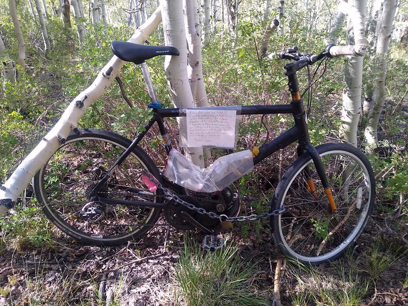
First stop: North Lake, my trek’s terminus. I parked in the Backpacker Parking Lot and removed the eBike from the rack, then looked around to be sure that no one was watching me. Then I quickly pushed the bike into a grove of aspens to the north. I did a bit of Bicycle Bushwhacking, and found a spot deep in the woods. I got out my chain and locked it around a tree trunk. I covered the electrical parts with a plastic bag and also taped a note to the frame. The note begged people not to steal it, and I promised them a reward for their honesty, payable in cash after they sent me an email. I also dated it. I wasn’t too worried, really, but it never hurt to give people a chance to Do The Right Thing. To make its theft even less appealing, I stashed the bike’s battery pack in one of the large Bear Boxes in the parking lot, in a cloth shopping bag, with a similar note. An eBike without a battery is just a bike.
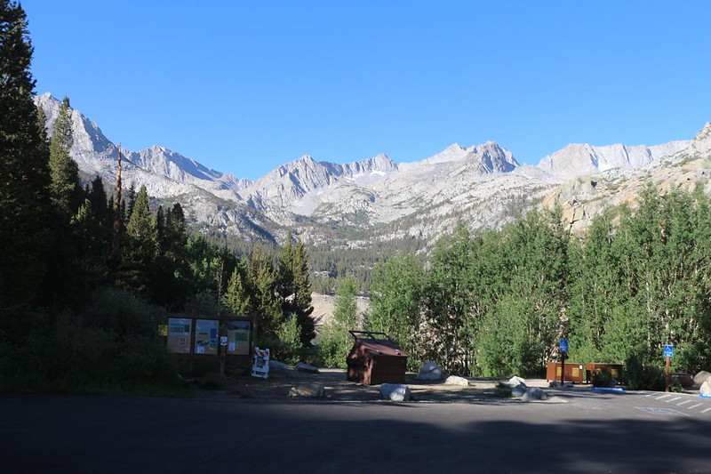
Well, I’d done my best, I told myself, and then headed off in the car to South Lake. It took a few passes, but I eventually lucked out and snagged a nice spot in the (very busy) overnight parking lot. I spent the rest of that day hiking up the trail a bit, and then slept overnight in the back of my car. Note that this isn’t really allowed, but I can say with certainty that I wasn’t the only one!

I woke up early, excited to begin the big trek. I was sad that Vicki wasn’t with me this time, but I was also happy to be here. The Wilderness Was Calling, as John Muir would say, and I was about to answer that call. I double-checked my gear and stowed everything else under the cover in the back of the car. I took a final photo of the car, put on my backpack, and started hiking uphill toward Bishop Pass.

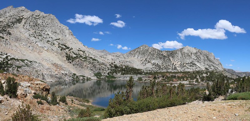
I hiked along the shore of South Lake, steadily climbing. Soon I passed beyond the John Muir Wilderness boundary, and slowly made my way up the switchbacks to Long Lake. Then the trail flattened out for a while. I made good time, and enjoyed the views of Hurd Peak, Mount Goode, and Chocolate Peak. The trail continued upward, and soon Spearhead Lake was behind me, down below on the valley floor, where I could hear the water rushing along in the South Fork of Bishop Creek. The air warmed as the hours went by, and everything was beautiful. I really love hiking this trail.

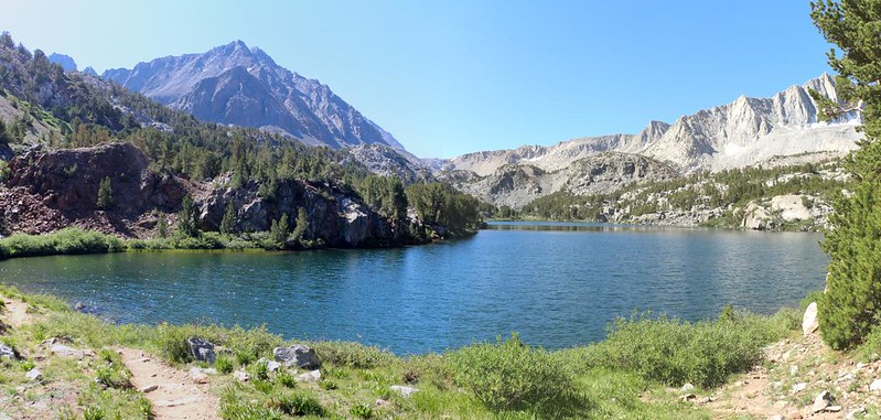
I passed the Timberline Tarns and Saddlerock Lake, then continued on into the upper basin, where the Bishop Lakes are located. I found a spot with a view and stopped to eat my lunch. Some puffy cumulus clouds were beginning to build, which was wonderful, as they make the photos so much better.

Then it was time to climb the headwall at the top of the valley. Bishop Pass was just beyond the many switchbacks. I was feeling good and continued hiking slowly but steadily. It seemed that I was nearly acclimated already, thanks to spending the past several days up at high elevation.

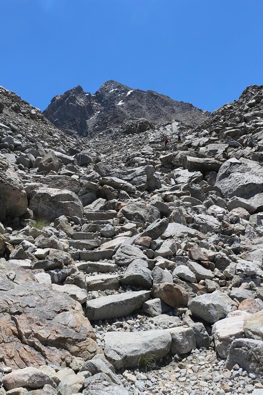
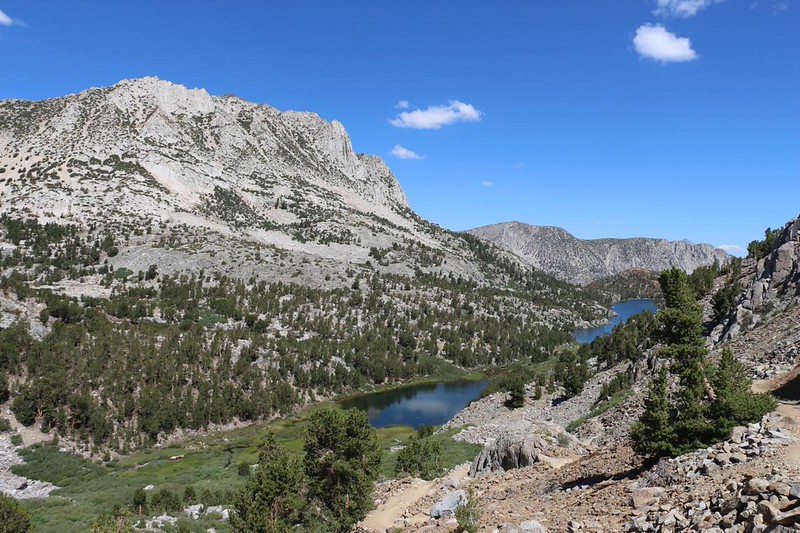
The switchbacks are quite steep, but they make up for it by having great views. I stopped many times just to breathe, and to take pictures. The Bishop Lakes were arrayed down in the basin, and I could see the tiny shapes of other hikers making their way, upward and downward, on the trail below me.
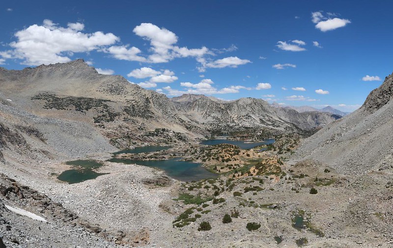
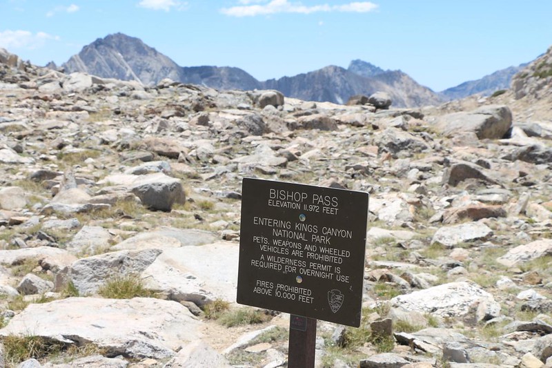
After a refreshing break on top of the headwall, I headed upward toward Bishop Pass itself. At 11,972 feet elevation, it was annoyingly close to the 12k mark. I decided to call it 12k anyway. What’s a few feet between friends? This was also the point where I left the John Muir Wilderness and entered Kings Canyon National Park. The line of the Sierra Crest ran right here, and it also marked the divide between watersheds and counties.

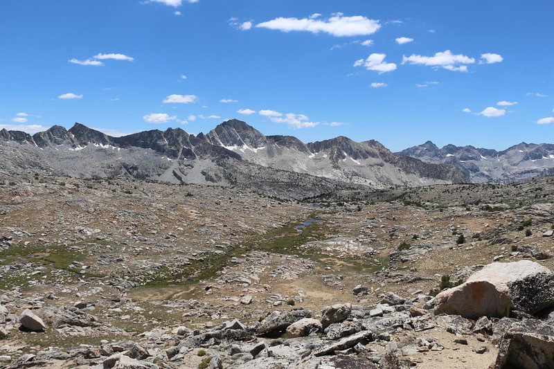
Continuing on, I descended into Dusy Basin, one of the prettiest spots in the High Sierra. Trees were few and far between at this elevation, and the ones that were able to eke out the long Winters were stunted and tough. Twenty thousand years ago, this entire basin was under a massive, slow-moving sheet of glacial ice. And it looked it: Stark and raw and harshly beautiful, with towering peaks of gray granite in all directions.

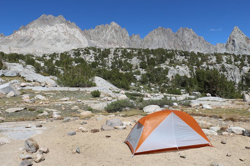
I planned to camp about two miles below the pass, at the same spot I’d camped the year before with my son when we hiked from Onion Valley to South Lake. I knew that there was a great view, with a water source close to camp. Elevation-wise, this spot was still above 11k feet, so I figured that it would be the final topping-off of my body’s acclimation adjustment. I’d know it worked if I didn’t have a headache and still had my appetite.
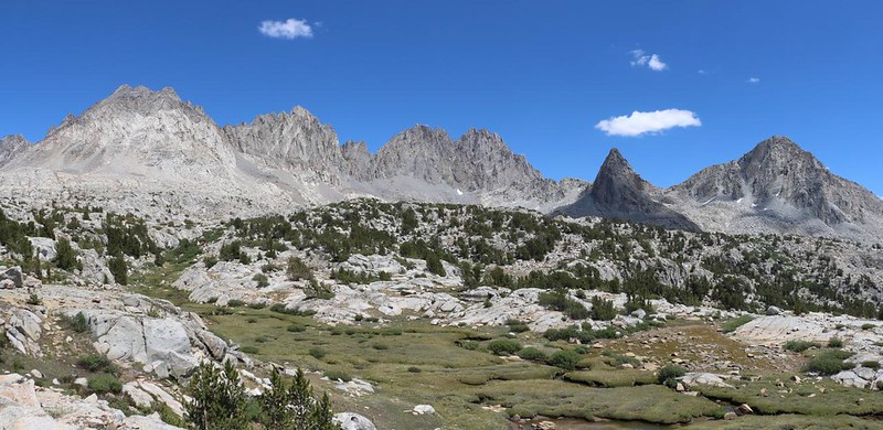

I put down my pack and got out my water gear, then headed for the pond. Afterward I came back and set up my tent. It was still midafternoon, and the sun was blazing down. I found a spot in the shade of a stunted pine and read my book, while glancing up and gazing at the Sierra Crest standing majestically before me. Ah yes. This is the life!
All told, I had hiked about 7.5 miles, climbed 2200 feet, and dropped down about 800 more. It wasn’t the biggest day of my adventure, but I didn’t really care. I figured that I could make up the miles another day, when I became even tougher, as my body became attuned to the rhythm of a multi-day trek.

As the sun went down behind a ridge, I ended up in shadow. It grew cool. I tried out a new freeze-dried meal, some sort of chili, and it was far too spicy for me. Ugh. I ate what I could but I admit that I left some beans in a hole downhill from camp. I made up for it by eating some extra snack. I had plenty of snack. I always do.
Then I sat in the tent and looked out at the Sierra Crest as the sunset turned the peaks orange. The shadow from the hills to the west slowly rose. I had spoken to two other hikers earlier, who had made bets on which peak stayed in the sunlight the longest. They refused to tell me the answer, so there I sat, watching and waiting. And I found out which one it was. Sorry, but you’ll have to go there yourself to get the answer. Ha ha!
For a topographic map of the hike see my CalTopo Page
For LOTS more photos of the trek see my Flickr Page
Onward to Day 2 >> 

