I took a fun dayhike up and around Chocolate Peak on the Bishop Pass Trail, out of the the South Lake Trailhead; it was the final part of my three-day plan to get acclimated to high elevation for an upcoming multi-day trek. I hiked over 7 miles and climbed 1600 feet, and saw many beautiful lakes and mountains. The South Fork Bishop Creek valley is one of the loveliest places in the High Sierra, and well worth exploring.
I spent the previous night camping at Horseshoe Meadows, and woke before dawn. I packed my gear and drove two hours north to the city of Bishop, where I stopped for a quick breakfast. Then I headed west, up Highway 168 to South Lake Road, and was lucky enough to find parking in the backpacker parking lot. Eventually. I circled and waited for almost a half hour, but I finally scored a great spot. I needed it for tomorrow’s six-day trek. Today, however, was only going to be a dayhike.
By the time I got my daypack ready and began hiking, it was already 10:30 am! All that driving and eating and gas-pumping really takes its toll. But that was OK, as I had time. My plan was to do a “Lollipop Loop,” hiking on the main Bishop Pass Trail, then counterclockwise around Chocolate Peak, after which I would be back on the main trail leading down to the car. So I set myself a rough turnaround time and headed out, hiking uphill above the shore of South Lake.
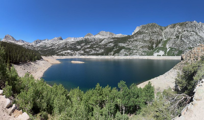
In this ultra-dry year of 2021, South Lake had already been drained, all the way down to dam level, and it was a bit of a shocker to see. This must be close to the original size and height of the “true” lake, back before they installed the dam. Wow!
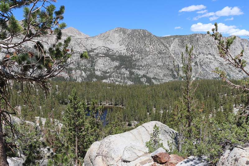
I hiked onward at a lively pace, climbing about 1000 feet in two miles. I’d been here several times in the past, but it still felt quite fresh and beautiful. It must have been that crisp, clean, High Sierra Air.
On the way up, I was pleased to discover that the lakes up above South Lake (natural lakes) were all quite full, and the creeks were still flowing decently. The grasses were still green, and there were even a few flowers. It was looking pretty much the way I expected a dry year to look in early July, but it wasn’t anywhere near as parched as it had been yesterday, down south in the Cottonwood Lakes area. They must have gotten more snow up here last Winter.

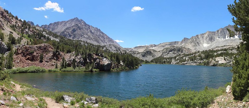
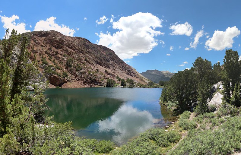
The trail led directly to Long Lake, and it was as full and lovely as ever. It was long, about three quarters of a mile long, and I hiked all the way to the southern end. I stopped for a lunch break, and sat on some big rocks near the shore. I had a great view down the entire lake. I spoke with a number of hikers, and found out that Dusy Basin (up above the pass) also had plenty of water for backpackers. I would be camping up there tomorrow, so this was good news.


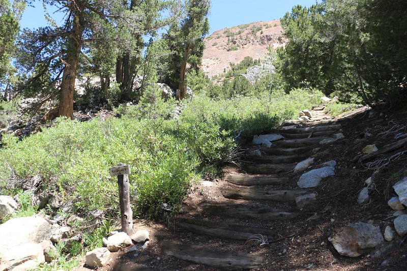
Technically, I had already hiked too far for a proper lollipop loop, but I really wanted to take my break down at that end of the lake. So after I ate, I retraced my steps a short ways until I intersected the trail to Ruwau Lake. This trail looked quite civilized from the main junction, with a series of log steps heading upward. I happily began climbing. As soon as the trail rounded the first corner, barely out of sight of the log steps, it suddenly got steep and wild. Not only did it start climbing in earnest, when it had reached the height of Ruwau Lake, it spread out into faint branchings and nearly disappeared! I even had to pull out my phone to double-check my position with the GPS on the map.
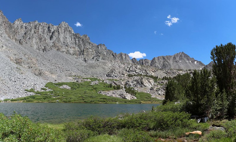
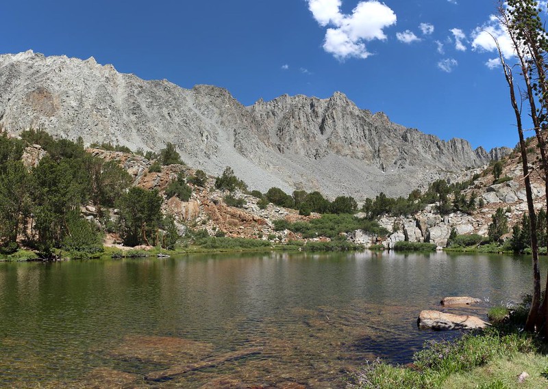
The trail(s) converged again at Ruwau Lake, and clung to the shoreline thereafter. The lake, located alongside the Inconsolable Range, is nestled between the arms of Picture Puzzle and Cloudripper. I was surprised at how large the lake appeared. At 11044 feet elevation, it was very high up, indeed. I didn’t test the water, but I felt quite certain that it was icy cold, like many High Sierra lakes. Instead, I hiked along the shore, taking plenty of photos and videos, as usual.

Video Panorama from the shore of Ruwau Lake

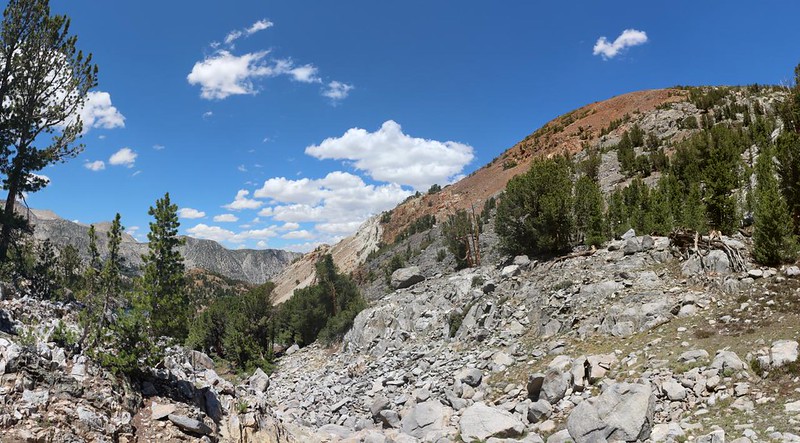
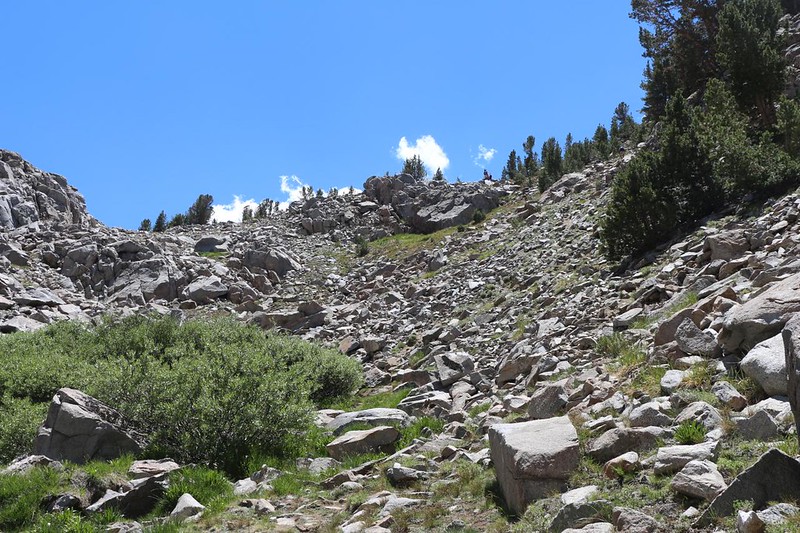
The next part of the trail was both uphill and downhill, popping up and over the southeast ridge of Chocolate Peak. It was steep but tolerable on the way up, but the northern side was another story. The descent was ultra-steep, with loose dirt, scree, and small boulders. On the way down, I lamented that I hadn’t brought my hiking stick along with me. I usually have a heavy camera in my hand, so I typically only use the stick when crossing slippery rocks in streams. I surely could have used it that day! I still feel lucky that my feet didn’t slide out from under me. But I made it safely down, so all was well.


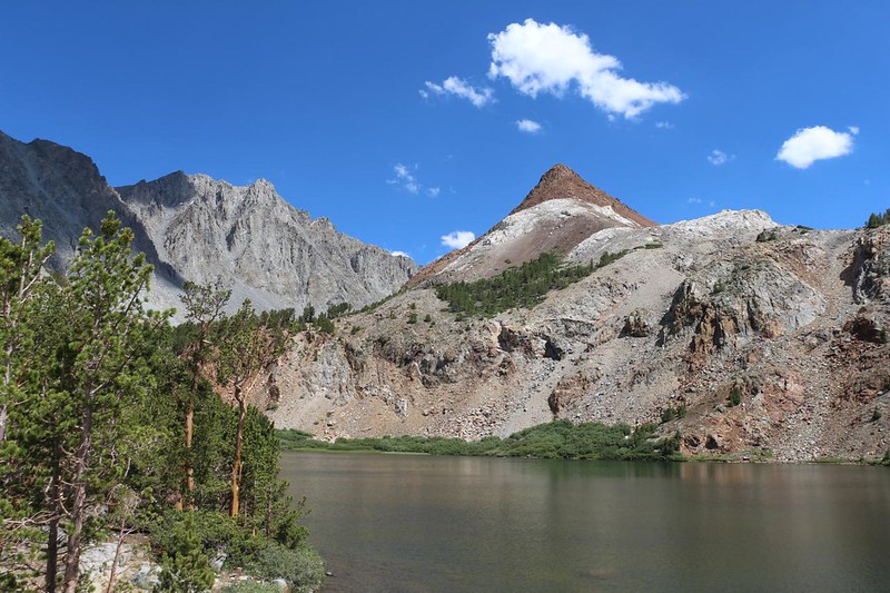
I arrived at the shore of the uppermost Chocolate Lake, and checked my map. There are three Chocolate Lakes in total, set like jewels in the deep valley between Cloudripper, Vagabond Peak, and Chocolate Peak. I met a group of hikers with a dog at this lake, just finishing their lunch. They were doing the loop clockwise. They had seen me sliding down the evil scree slope. I fibbed a bit about it to hearten them, telling them that it wasn’t so bad, and wished them luck on the climb. Then I continued on.

I soon discovered that middle Chocolate Lake was very pretty, and it had a fine view of Chocolate Peak. With the vast expanses of gray Sierra granite all around, I have to say that the peak’s reddish-brown color (chocolate, of course!) was quite stunning and special. Really a beautiful spot.

The trail did a fun curve through the three lakes, staying to the west of the upper lake, crossing the connecting creek and going east of the middle lake, then crossing the creek once more to go west of the lower lake. It was this last crossing that was tricky. Once again, the trail did its old trick of splitting into faint paths. It either crossed slippery rocks without a trace, or dived into thick willow bushes before crossing on invisible slippery rocks. Whew! I was thankful that this wasn’t snowmelt season, and managed to cross with dry boots.
Lower Chocolate Lake was the smallest of the three, but in some ways it was the loveliest. I liked the way the land dropped away below it, and imagined this bowl being carved by glaciation during the last ice age. Many High Sierra lakes were formed like that, and are similarly perched in high canyons above cliffs and headwalls.

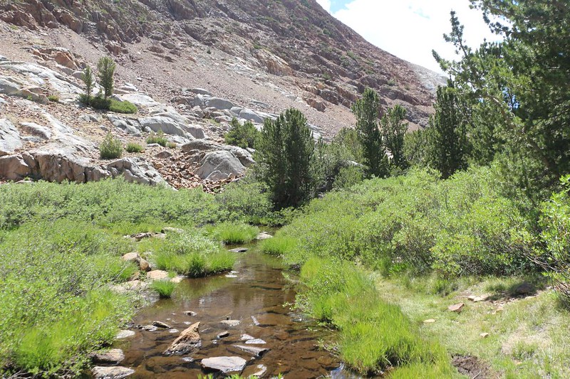
The trail continued downhill, along the flank of Chocolate Peak. The northern side of the peak had some interesting white stone, which I immediately dubbed “White Chocolate.” I like both types of chocolate, so it’s all good. The trail generally followed the creek, and crossed it yet again before arriving at a viewpoint above Bull Lake. My map showed it continuing its sinuous character, by heading east around the lake.


Bull Lake was the final lake on the “loop” section of the day’s hike. It was peaceful and pleasant. I met up with two young ladies along here, and we spoke of good places for day-hikes along the Eastern Sierra. I gave them a few tips, while they really raved about the trails near Mammoth Lakes. I told them that I had never been there, but was planning to go there with Vicki one of these days. Maybe sooner, I thought, after listening to their enthusiasm. I put it on my list of places to investigate. They also liked my idea of calling it “white chocolate” and we laughed a bit. Down at the northern end of the lake, we all turned and got a great view of Chocolate Peak. With Cloudripper behind it, the scene was beautiful.

Panorama video from the shore of Bull Lake
The main Bishop Pass Trail wasn’t much further down below the lake. The Loop part was finished, so I turned right to complete the “stick” of the lollipop. Then it was merely a matter of descending two miles and a thousand feet to the trailhead at South Lake. Because it was downhill, it only took me an hour or so. I was blasting right along.


When I arrived, I headed over to the car to take another break. My feet were feeling fine, and my lungs, as well. I decided that I was perfectly acclimated to elevation now, after the hikes of the last three days. Not only did I properly prepare for my big trek, I also had a really fun time doing it!
For a topographic map of the hike see my CalTopo Page
For LOTS more photos of the trek see my Flickr Page

