The second day of our trek was spent hiking from the Kearsarge Lakes, up and over Glen Pass, and onward to the Rae Lakes, where we met up with some seriously dense smoke and ash from the 2020 California Wildfires.
The day started just after midnight, when I woke up smelling smoke in the air. “Oh, no! Not this again!” I said to myself. I had been hoping that we’d left the smoke behind, down below in the Owens Valley. But no. It was up here at 11,000 feet. I peeked out the tent door and saw the full moon high above, and it was reddish orange. That’s never a good sign. But I couldn’t change it any, so I went back to sleep for a few more hours.
On my last trip I learned to get up early, in order to get the hike started while it was cool and to get it over with before any afternoon thundershowers, so I had the alarm set for 4am. We woke up in the dark and ate breakfast, then packed up our gear. The moon was still red. By the time we left camp at dawn, we could see that the smoky haze was everywhere. Oh well. There was no turning back, as our car was fifty miles to the north. So on we hiked.


We were the first to get ready that morning, as it was Monday on Labor Day Weekend. Most people knew that they had to go home and work the next day, so why get up early? But we had a good solid week of hiking ahead of us, and the further north we went (away from the SQF Complex Fire) the better the air would be.
And it wasn’t just smoky. There was a gentle snow-like shower of fine white ash floating down everywhere. We could see it easily in the beams of our headlamps. This made us decide to put on our Covid-19 cloth masks, to protect ourselves from the ash particles. As we left the Kearsarge Lakes area, I remarked to one of our neighbors, who was cooking breakfast in camp, that this was the first time since the beginning of the pandemic that I truly felt that this annoying mask was finally helping ME. We all laughed because it was so true.


After leaving the lakes, our next goal was to climb up to the main Kearsarge Pass Trail, also known as the High Trail, which headed west, high above the Kearsarge Basin. We initially ventured cross-country, northwest on a diagonal path, until we intersected the trail, which saved us at least a half mile of hiking. The trail then took us toward the Pacific Crest Trail, and stayed high up above Bullfrog Lake. If it weren’t for the annoying smoke, the views would have been great all along this part of the hike.


The sun was just rising over Kearsarge Pass as we got to the west of the basin. We turned around and saw a faint orange ball through the thick smoke and ash. It was pretty darn miserable out there, and we weren’t exactly thrilled to be using up our valuable vacation time by hiking in these hellish conditions. But what could we do? I was expecting a change in the weather pattern in a day or so, but meanwhile we had no choice, really. It was either hike onward or quit and return to Onion Valley, then pay for an expensive shuttle to get to our car west of Bishop. And that wasn’t going to happen. So on we hiked.

The trail intersected the PCT/JMT, and soon we were hiking north. The trail stayed high up above Charlotte Lake, which we could still see plainly down below us, although Charlotte Dome, miles down the canyon, was almost completely obliterated by the haze. Vicki and I had been here a year ago, back in 2019, and the contrast in conditions was amazing. I apologized to my son for bringing him here with this gloomy air, but he didn’t seem to mind all that much. After all, how often do you get to hike in the High Sierra with your dad? Not often enough, and that’s for sure. So both of us decided to be happy about it and move on. No apologies needed. Life was good again.


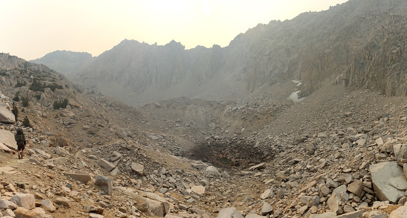
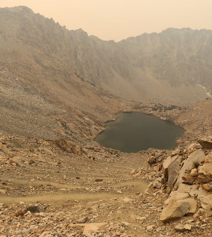
The trail continued climbing and rounded the corner on its way to Glen Pass. This would be the second of five passes that we would be summiting on our week-long trek, each of which was roughly 12000 feet in elevation. We climbed up past the two large tarns that lie south of the pass. The first one was completely dry, as if the water had drained out through the jumbled rocks, while the other one was still full, most likely due to the fact that it’s bottom was solid granite. We stopped and took a short break at the upper lake. We ate lunch and looked at the people up on the pass, and watched as they came down the switchbacks.
GoPro panorama video of Glen Pass from the lake shore to the south of the pass

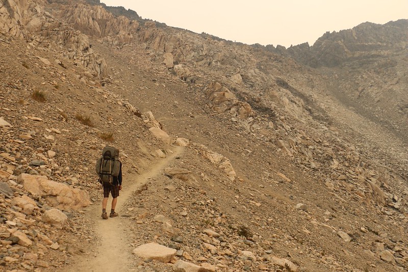
After that, it was time for us to hit the switchbacks. So we started climbing. We watched the orange sun as it reflected on the lake below us, and kept on grinding up the hill. We only had another 500 feet to climb, so it went fairly quickly. But there sure were a lot of switchbacks!


We made it to the top and took off our packs. And I have to admit, the views were pretty darn miserable, considering what they should have been without the smoke. Oh well. We enjoyed it just the same. There were a bunch of people hanging out on top. One of them was Sara Schulting-Kranz, and she let us sign a poster about her “Walk Through This: A Story of Starting Over” book. She was nice, and really upbeat, so I told her I’d give her a link in my blog. After that, we took the usual photos and videos, but didn’t hang out for long, as it was quite breezy up there.


GoPro panorama video from the top of Glen Pass on a smoky Labor Day 2020

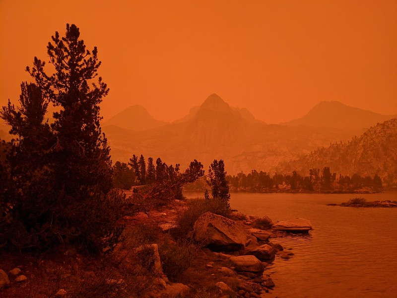
This year, in late-Summer 2020, there was no snow whatsoever on the north side of Glen Pass, so the descent was easy. Lots of non-icy switchbacks. It was about 1500 feet downhill to reach the Rae Lakes, which we could almost see off in the distance to the northeast, and we made great time.


The smoke seemed to be less intense when we first arrived at the lakes. The granite was more granite-colored, and we could even see the surrounding peaks. It was still a bit hazy, but that was fine with us. We came to the water crossing between upper and lower Rae Lake, and I was surprised to see that it was an easy rock-hop, which was nothing like the thigh-deep wading experience I’d had last year. I looked at the low water with sadness. I’d carried my plastic water-shoes and hiking stick specifically for this crossing! What a waste of backpacking-weight! Oh well. I was certainly stuck carrying their dead weight now. True, there were other crossings further north, but I didn’t see much hope as the water was low everywhere this year. It was truly a case of Grin and Bear It.

Video of the creek between the Upper and Lower Rae Lakes where the PCT crosses onto the isthmus

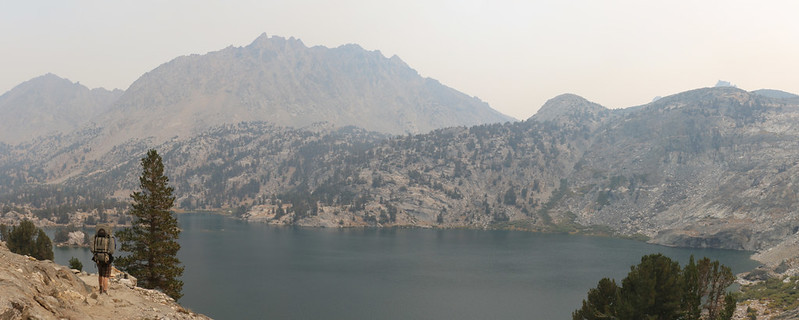
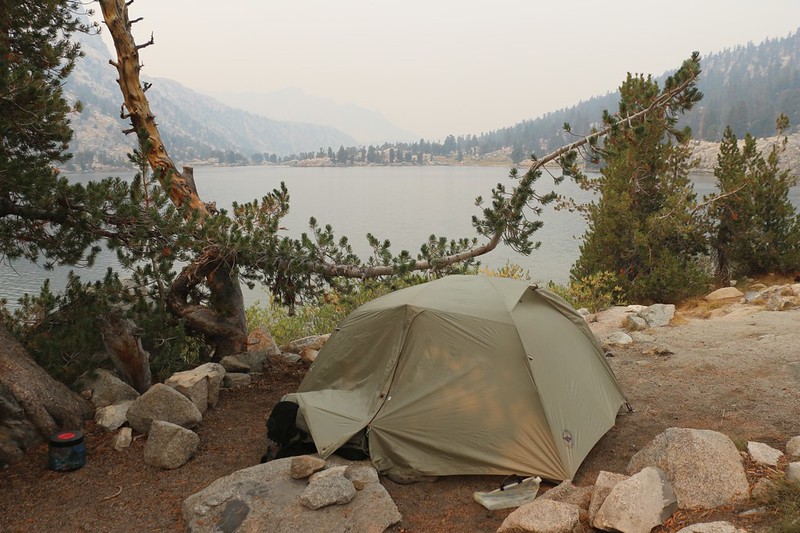
We hiked around lower Rae Lake to the large, well-used PCT-JMT campground. It even had large metal bear boxes from the old days before bear cannisters. We got there just after noon, so we had our choice of many prime camping spots. We chose one with some shade, under a tree near the shore of the lake, and put down our backpacks. We had hiked about 7.5 miles that day, which wasn’t a lot, but it wasn’t a little, either. Just a good solid day of hiking. We set up the tent and started getting our gear inside. Then we hung out and ate some lunch. We checked out the views south toward Painted Lady, and north toward Fin Dome. It was a fine place to camp.

The afternoon was when the craziest part of the entire trip began. We noticed the sun getting more and more orange-colored, and then tiny particles of ash began falling, but even heavier than earlier that morning. I got out my trusty cloth Covid mask and put it on. But it didn’t do a whole lot. The smell of smoke grew much, much stronger. Over the next hour or so, the sky became so red that we could no longer see the sun through the cloud! The air quality was horrible. I took a couple of photos but I decided to retire into the tent to avoid breathing the falling ash. I got out my book and decided to read it for awhile. But soon it grew so dark (at 3pm!) that I had to get out my headlamp in order to read. It was crazy. I began to wonder if maybe a newer, closer fire had started. I got out my InReach Satellite communicator and sent a text to my wife, asking her to check for me on the internet, but I didn’t get a reply until the next morning. It turned out that there weren’t any new fires.

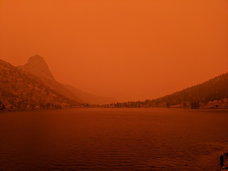

Eventually, of course, the worst of the smoke cloud drifted elsewhere, and a degree of normalcy returned. The sun was only slightly orange, and the granite looked like granite again. My tent was an olive green color once more, and we could breathe the air without inhaling ash. We purified some drinking water from the lake by running it through a sterile filter (because lakes have lots of floaty stuff in them and I don’t trust the chlorine drops to do the job as they are stoichiometric in regard to the load of foreign organic matter), and we were glad we did after speaking to one of our neighbors. He used iodine drops, but he also had LOTS of floating ash particles in his water. Apparently, the upper six inches of lake water was cloudy with ash! He drank it anyway, but he wasn’t exactly happy.

We ate some dinner and hung around outside for a while. Some of our newer neighbors arrived and we heard them whooping as they swam in the icy lake. I didn’t have the heart to tell them that they were now coated in ash. But maybe they were already coated from earlier that afternoon. I can state for a fact that my tent still smelled of smoke months later! That ash and reek absolutely permeated the nylon fabric, and storing it rolled up in my backpack all that time didn’t help it any. We stayed awake long enough to check whether there would be any sort of decent sunset, but there wasn’t. The red sky earlier would have to suffice. And then we went to sleep.
For a topographic map of the hike see my CalTopo Page
For LOTS more photos of the trek see my Flickr Page
 << Back to Day 1 Onward to Day 3 >>
Up to “Onion Valley to South Lake 2020”

