On the third day of my trek from Kennedy Meadows to Walker Pass, I hiked south from Chimney Creek, up into wild storm clouds, down into Spanish Needle Creek, and over the ridge to Joshua Tree Spring, where I dared to drink the dreaded Uranium-containing water, and lived! Whether I gained any superpowers afterward has yet to be determined.
It was a bit after midnight when I woke up in the dark, to the moaning sound of swirling winds high above me. The tent was sheltered, deep within some trees, but even so the nylon tarp made flapping noises every so often as it shook from an errant gust. The temperature had dropped and my feet were cold. As long as I was awake, I decided to go outside and relieve myself. While there, I looked up at the sky. The full moon was not in sight, but I could see the outlines of clouds. They were moving right along. I had known that there might be some weather arriving that morning, but the most I could do about it was hope that it didn’t rain too much. So I went back inside and put on my goose down pants, and my puffy down socks. I had gone to bed wearing the warm down jacket, but left the sleeping bag half-unzipped. It was too warm otherwise. By midnight, I had already zipped the sleeping bag all the way shut, and I was still cold. But no longer. As a final gesture of defiance, I put on my goose down hat, and my wardrobe was complete: I was fully coated in downy feathers! It didn’t take long before I was sleeping happily, utterly ignoring the wind and cold.

By first light, the wind was still howling up above the trees, but it hadn’t rained. Yet. One of the hikers I met yesterday mentioned that the forecast had backed off on rain chances for this storm, but I knew that, in the mountains, anything could happen. Meanwhile, I was grateful that my tent and gear were still dry. I ate some oatmeal, changed into my day clothes, and packed everything up. I kept my goretex raingear on, top and bottom, to act as an extra, windproof layer, and started hiking up the canyon. Climbing would keep me warm.
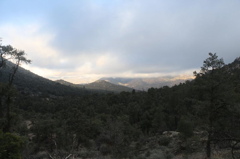

I kept my hood on under my hat to block the cold wind from my neck, and continued upward. The cumulus clouds were blowing by rapidly, so there were interludes of warm sun, followed by chilly shade. The first saddle looked toward Sand Canyon in the southeast, which was mainly in sunlight, and then the trail continued upward toward Lamont Benchmark, and crossed over another saddle. This one was above the cloud ceiling. Off to the west (where the wind was coming from) I saw virga and a rainbow. I wasn’t thrilled about getting wet, but at least I was prepared for it, so I hiked onward. No point in stopping now, I thought, as it was far too cold and windy.
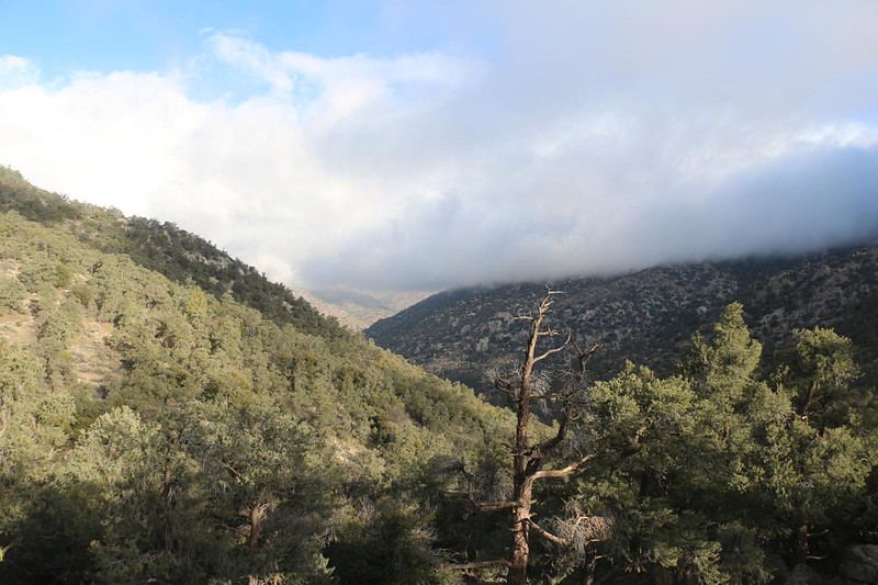

The trail continued along a ridgeline, and the wind was impressive. Clouds and shreds of mist were blowing by, interspersed with windy sunshine. But at least it wasn’t raining, and I must admit that it was kind of fun! Most of my photos happened during periods of sun, so this report is a bit skewed in favor of pictures with better visibility. When the mist was blowing I kept my big camera tucked inside my jacket to keep it dry. Interestingly, the pine trees next to the trail had been collecting mist drops on their needles all morning long, and when a gust hit, they would discharge large droplets that would launch downwind. I got hit by many of them, but it sure beat hiking in a driving rainstorm.


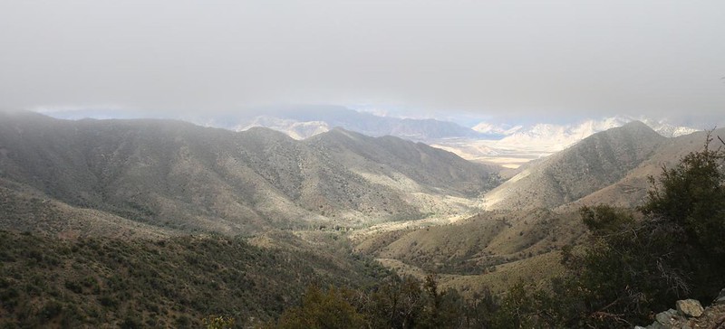
I hiked for over two miles along that ridge, staying at roughly 7000 feet elevation, and I was up there when the front of the storm passed by. That was when the sun disappeared for an hour or so. I was hiking in a land of cold blowing mist, and breaks in the clouds were rare and fleeting. Somewhere along there I crossed from Inyo County into Kern County, but they didn’t bother to post any signs. Ha ha! It was all the same gray world to me.


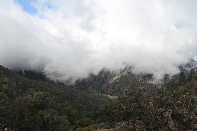
As I neared the end of the high ridge, I took a selfie to send back home (when I got back into range). I reached the final saddle and took a short break on the leeward side. My backpack had been sprinkled with blowing spray, and my jacket was damp with mist droplets, but otherwise I was dry. Down below me was Spanish Needle Creek. The entire valley was roofed with clouds, but there was sunshine off in the distance to the southwest, toward Lake Isabella. I hoped that the worst of the storm had passed, and was glad that I wasn’t trekking further north in the High Sierra, where it was probably snowing.

I had already hiked almost five miles, and a break was welcome. I sat and ate some snack while checking out my map. It looked like I had another four or five miles to go to reach the low point, 1900 feet below me in the bottom of the valley. A typical ten percent PCT-style grade. It promised to be easy hiking. Plus, there were several opportunities to get water along the way. Not that I needed any. I hadn’t been sweating much at all in the cold weather, and I was probably carrying too much of it, as always. That’s what happens with us retired Boy Scouts: “Be Prepared” really is our lifelong motto.


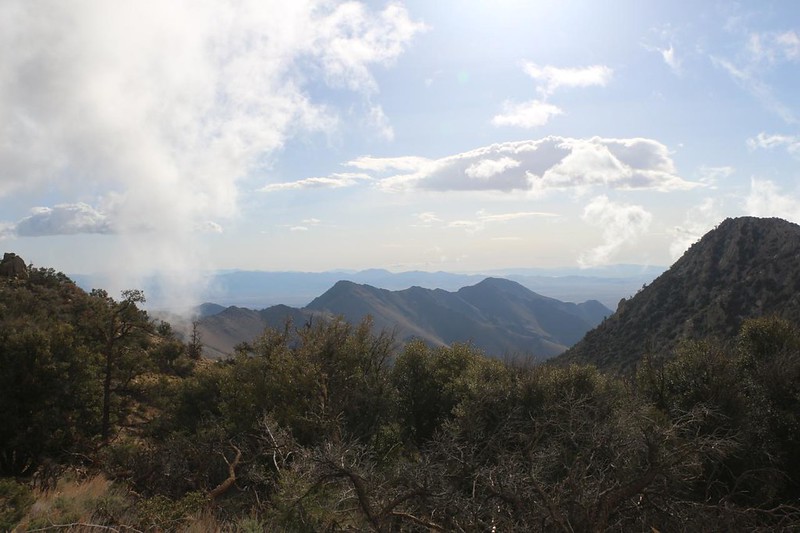
After taking a good long break next to Spanish Needle Creek, the PCT proceeded to climb up and out of the canyon entirely. This was typical Pacific Crest Trail sneakiness. In fact, I had another 800 feet to climb! But I was getting used to it by now. I watched carefully as the cumulus clouds continued to scud across the sky out of the west. It really did look like the storm was ending and the clouds were breaking up. They were no longer clinging to the top of the ridge I had recently hiked over, but there were plenty more stacking up in the distance to the west. The wind wasn’t slacking off, however, and it was directly in my face as I climbed. I had yet to remove my windproof raingear, and the air remained cold.

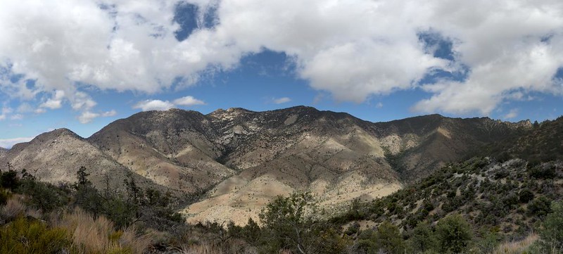

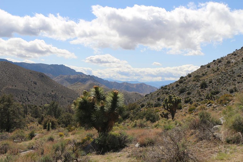
Upon reaching the ridgetop, it was obvious that I was entering a dry region. Joshua trees and other high desert plants appeared, and the pine trees were scarce. Cow Canyon was the name of the next declivity, but I didn’t see any cows. And not much sign of water down in the bottom. It was dry, all right. But that didn’t matter much to me, and I continued hiking as usual. I had about three more miles to go that day, and I wanted to get it over with. Meanwhile, there were plenty of views, and the residual clouds made for some pretty pictures. This was much better than hiking in that blowing mist.


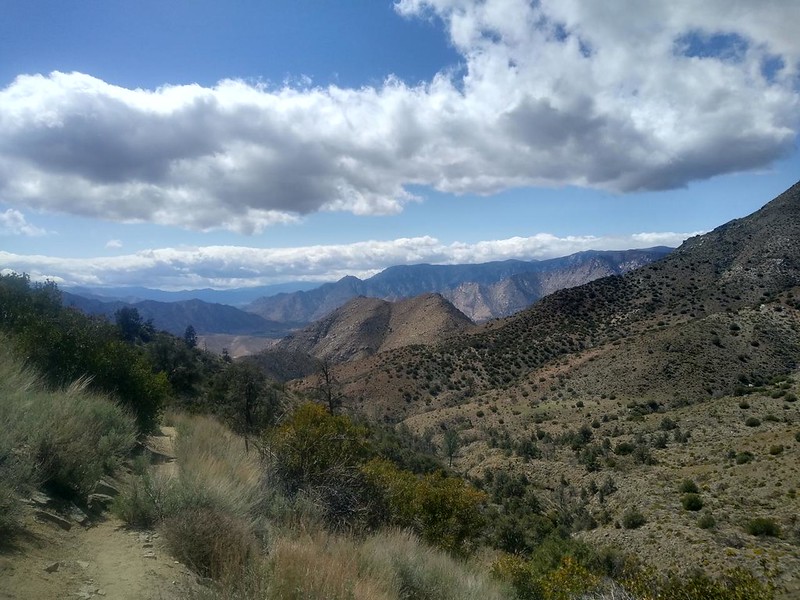
Just to be annoying (as usual), once I reached the dry creek bed at the bottom of the valley, the trail insisted that I climb several hundred feet more! By this time, my feet and legs were not amused. But I trudged onward anyway. Up ahead I could see Owens Peak (8453 feet elevation), the namesake of the Owens Peak Wilderness, which I was hiking in now. It had interesting stripes of light and dark granite on the western face. Checking the map, I realized that tomorrow morning I would be climbing up and over the nearby pass, and I saw faint signs of switchbacks on the slope. Oh well. I would worry about that when the time came.

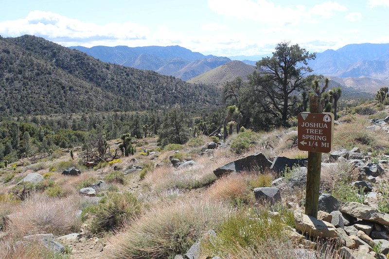
I was thankful to see the sign for the side trail to the spring. Only a quarter mile to go! And it was all downhill from there. I kept my eyes peeled for campsites along the way, and I found a few, but it was still too breezy to set up a tent in such an exposed area. Once I arrived in the canyon, it was another story. Pine trees abounded down there near the water source, and they provided shelter from the wind and sun. I found several tent sites along the path, which led to a long concrete trough filled with water. Water that had tested positive for uranium!

I wasn’t all that worried about the uranium, to tell the truth. It supposedly contained several times the maximum levels deemed safe by the government, but I knew that this rule was designed for people exposed to it over a long period of time. Drinking a gallon wouldn’t be much of a risk. And barely a risk at all compared to the risks we hikers take on a daily basis out in the wilderness! Reading the comments on the Guthook PCT App was quite amusing. Some folks shunned this spot like the plague, while others drank the water, hoping to get Super Powers like Spiderman! It was obvious which ones understood science. Namely: The ones with a sense of humor!
Just the same, the water in the trough, while crystal clear, still had plenty of things living in it. Algae and filimentous weeds grew on the bottom and sides, water striders danced on the surface, and mosquito larvae flipped and wiggled within the depths. I cared more about that than the uranium. I didn’t want to clog my filter! Luckily, there was still some decent flow in the creek down below the pool, and I collected my gallon from there.
The app also mentioned that cell signal might be found nearby, so I climbed up the trail a short distance. I could see a bit of Highway 178 in the distance, and that was enough. I called Vicki and spoke with her about picking me up the next day at Walker Pass. After spending three days essentially alone, it was nice to hear a friendly voice. I only had twelve miles left to go, but I had a feeling that she would arrive early, due to her desire to avoid L.A. traffic. So I said goodbye, and set my alarm for 3:30am. I, too, would arrive early, if I could.
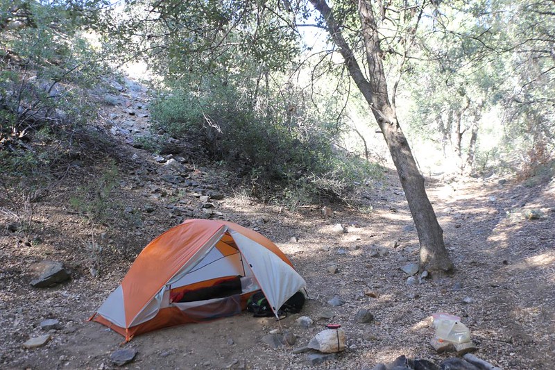
After that, it was time to set up my tent and eat some food. The afternoon was getting on. I changed into my night clothes and fired up the stove. Soon enough, I had a cupful of hot ramen noodles, and the salty broth tasted great. I ate some more chips and some other sweet snacks. Life was good at Joshua Tree Spring. Or was it the uranium that made it seem that way?
For a topographic map of the hike see my CalTopo Page
For LOTS more photos of the trek see my Flickr Page
 << Back to Day 2 Onward to Day 4 >>

