Vicki and I backpacked on the Pacific Crest Trail from the Mojave Dam in Hesperia to Interstate 15 near Cajon Pass. We’re fairly wimpy hikers, so it took us four days to hike 29 miles! Why did we do it? Because this was just about the final piece of PCT Section C that we had left to hike.
The part of the PCT just before this one, from Big Bear to the dam, was detailed on my Trip Report from 2016, for those who like continuity. The Pilot Fire burned soon afterward, and that put a pause on finishing this section. It’s at a fairly low elevation, so it was mostly chaparral that burned, but it’s growing back nicely now. It was time to get this done, for completion’s sake, if nothing else.
We took two cars from San Diego and left one of them near the Highway 138 ramp at I-15, then drove to the trailhead parking lot on Highway 173 near the dam in the other one. We may have stealth-camped in my car that night, because we started the hike very early the next morning.
Day 1
We woke up before dawn and got ready. The plan was to hike a few miles to the only reliable water in this area, then hike a few more miles, to one of the few campsites in the area that was roughly midway between the trailhead and the Silverwood Lake campground. The plan was to hike six miles the first day, then eight miles or so the next. Pretty wimpy, like I said.


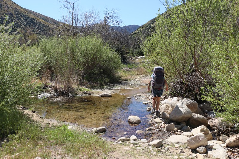
We took a long break with our boots off at Grass Valley Creek. It was already getting hot, and it was nice to find a bit of shade in this area of low brush that hadn’t fully recovered from the wildfire. We purified two gallons of water from a spot just upstream from the crossing. Unfortunately, I had to carry that extra 16 pounds for three miles, but that was part of my plan for this hike, and I had purposely brought my big backpack along, precisely for this reason. Sometimes, a man’s gotta do what a man’s gotta do.

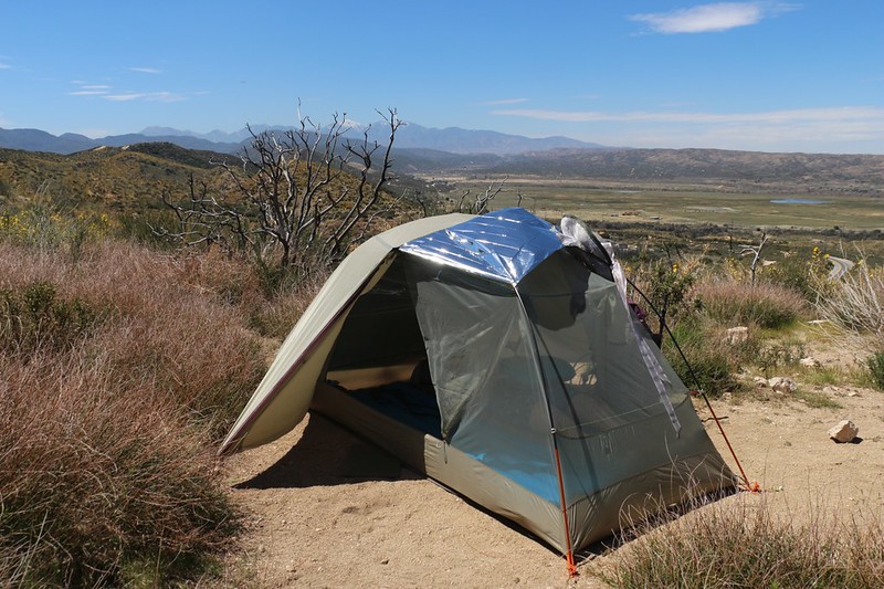
The next three miles went by quickly, and it was still early afternoon when we got to camp. Temperatures were in the upper seventies, and it was hot out there without any shade. So we set up our tent using a mylar space blanket to block the sun. This works great! Highly recommended, and it weighs almost nothing.
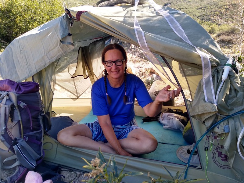
We laid around in the shade of the tent with the flaps wide open to catch any stray breaths of air. We both read our books and generally took it easy. Some might say that we should have kept on hiking, but to them I say: “Why?”

It got cooler later on, and we used up some of that precious water to make dinner and fully rehydrate. The high clouds blew in from the west and made the sky pretty, and we generally lazed the rest of the day away. Life was good.
Day 2
Technically, we were northbound on the PCT, but the trail went almost exclusively west in this section. It stayed high up on the hillside above the Mojave River Forks until it met up with the Silverwood Lake dam, after which it climbed up and over a ridge to arrive on the shore of the lake. There were at least five miles of trail along the northern lakeshore, so it was a large lake. At one point we cheated and took a dirt road “shortcut” that actually saved us almost a mile of hiking. And we didn’t care that we skipped a bit of PCT. What with all the fire closures and endangered frog restrictions, nobody hikes the entire PCT any longer. I figure that just doing what you can is good enough.


We eventually neared the Silverwood Lake Dam The trailside in the area showed many signs of man’s handiwork. In other words, it was a bit industrial. Big pipes, barbed wire fences, mounds of dirt, and electrical dynamos were placed in various spots. To me, this is merely a different type of scenery. And it was still quite interesting.

Video of hundreds of Swallows flying around the bridge by the Silverwood Lake Spillway


It was getting hot by the time we passed the powerplant, but we buckled down and climbed up over the ridge to the lake. There were plenty of fishermen out on the water in small boats, hoping to get some dinner. And, naturally, there was one bozo in a mufflerless powerboat roaring away by himself, his noise echoing off the lakeshore, impressing no one, while scaring away the fish. But he headed back to the marina soon enough, and all was peaceful again. I have to admit that we were impressed with the size of the lake, and, since it was still Springtime, the plants and grasses on shore were green and thriving. Very pretty.


We took a break for lunch along the lakeshore, and took out the map. I pointed out to Vicki that the PCT made its way along the shore of a peninsula that thrust far out into the lake. I also showed her that there was a dirt road that headed more directly toward our goal of reaching the campground. She was getting a bit overheated and tired by this point, so we opted to take the shortcut. I warned her that it climbed up and over a ridge (which became the peninsula). It climbed uphill about as much as the PCT, so she said she’d deal with it. She’s not big on climbing during a hot day in the sun.


The dirt road descended a bit too steeply for us, but we rejoined the PCT without issue. We followed the trail toward Highway 138 and turned left on the paved road leading into Silverwood Lake State Park. We had reservations for a campsite in the main campground, mainly because I couldn’t find any good (legal) spots to camp for free in the area. It turned out that I was wrong, that the ever-cheap PCT hikers always find a way to save money, but by then it was too late. So we hiked into the public campground and set up our tent.


We also spent some quarters we got from the rangers and took a shower at the campground. It felt nice on a hot day, and it was different from our usual trips where we simply stink to high heaven. The benefits of civilization. We also lucked out and there weren’t any drunken yahoos near our campsite (NOT a benefit of civilization) so we got to sleep at a decent hour.
Day 3
On this day we had about 7 miles to hike. Once again, reliable water was a concern. The only stream that was still running this year was about 3.5 miles away, and the only decent campsite (midway between the lake and I-15) was 3.5 miles beyond that. Yes, I carried that extra 16 pounds all that way.


Along the way, I saw a potential shortcut on the map – an old road that chopped a mile off our day – but it was very steep! I warned Vicki that it might be overgrown, and that we might have to hike back down this big hill, but she decided to take the chance. Slowly, but surely, with many small steps, we climbed the hill.

The first part of the road was paved, in order to service a large water tank on the hill, and after that the old road was basically gone. The chaparral had taken over since the last fire. Luckily for us, some kind soul(s) had re-opened the road and cut back the ceanothus and buckthorn plants. Otherwise, we would have had to hike back down. And it turned out to be a fun trail. Sometimes taking a risk pays off!


When we discovered that this old trail was originally part of the Pacific Crest Trail, we were overjoyed. It was like we weren’t really cheating anymore! Ha ha! In fact, the new PCT trail was currently the true “Long Cut.” We laughed all the way up to the junction with the main trail.
After that, we hiked up and over the ridgetop, and then swung around to the west, with the trail staying high up above Horsethief Canyon. Once again, we hiked with good views. The PCT really delivers!


All I had to do after treating the water with chlorine drops, was carry those two gallons a few more miles. Luckily, it was mostly downhill, as the trail made it’s way into the canyon. There were a few ranch houses down below us, and one had a lonely dog that must’ve heard us talking, because he started barking away, his deep-throated outrage echoing around the canyon. I barked back. Dogs are allowed on the PCT in most places, but they don’t own any of it. No matter what they think.

The trail went down as the canyon rose up, and soon we were at the bottom. Somewhere up ahead was our next campsite. We took off our packs at the first obvious spot, but it was right next to the trail. Not optimal. Vicki sat in the shade while I ranged forward. There were a lot of options, all of which were better than that one. So we put on the packs and I showed Vicki some options. It took us quite a while to choose the best campsite. To be honest, we didn’t really like any of them. They were all equally shadeless and roasting hot, and there were so many to choose from. We finally found one that promised to get shady later on, and set up the tent, using our trusty mylar space blanket again. After that, it was just another mellow afternoon reading our books. It’s a tough life, but somebody has to do it.
A few other hikers went by, but all of them were intent on reaching the McDonalds at Interstate 15, and nobody even noticed our tent. Sometimes, it’s nice to be invisible. Keeps you out of trouble.
Day 4
This was our final day, and the track profile showed a bunch of climbing, followed by a long descent. Seven miles total, and then we’d be back at the other car. Vicki insisted that we get the climbing over with while it was still cool, so, once again, we woke up in the dark, and even got started hiking in the dark.

Sound of a freight train’s horn at dawn – we heard these all night long

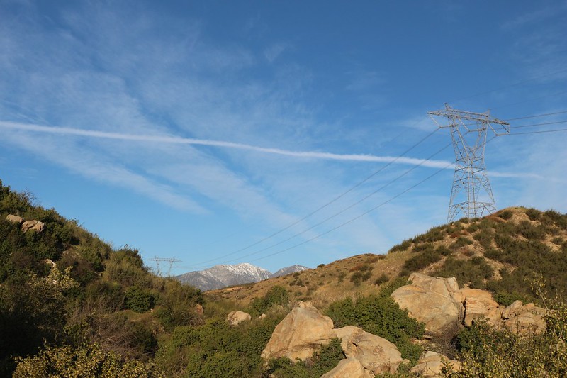
We hiked onward, eventually reaching the upper end of Horsethief Canyon. That was when I got the biggest surprise of the entire trip. The view west was incredibly glorious! We could see the PCT snaking its way along, following an undulating ridgeline down below us, and in the distance was the snow-capped magnificence of the San Gabriel Mountains. I got out my PeakFinder app on my phone and began naming off the array of peaks. Vicki and I had climbed many of them, and others we knew by sight. It was like a homecoming. I traced for Vicki the route we took back in 2019 when we hiked down from Wrightwood to I-15 and almost got caught in an ice storm. Very exciting. It made us thankful for the pleasantly breezy day we were enjoying right then.


After that, there was nothing to do but hike the long trail down to the car at I-15. And there was plenty of breeze, and plenty of views, the entire way. What a great section of trail! We thoroughly enjoyed it.


Eventually the views ended as we descended into Crowder Canyon. As it turned out, this used to be the main road over Cajon Pass, back in the early automotive and horse wagon days, and there were still traces of the old pavement here and there. Most of the old road had tumbled into the creek in the narrow sections of canyon, but the trail was fine.


Eventually, we heard the sound of trucks and traffic. The trail rounded a corner and we were smote with the full sight and sound of a busy four-lane freeway: Interstate 15, on it’s way uphill to Cajon Pass, with Barstow and Las Vegas in the minds of the countless drivers blasting by. Long freight trains rumbled past on three separate tracks. It was a very busy corridor. And one tiny part of its busy-ness was the humble PCT with its dozens of daily hikers.


All in all, it was a pretty decent hike. It was our first backpacking trip of the 2021 season, so we decided to begin with something easy, to make sure our gear was in proper order. It also had to be at low elevation, to avoid snow. Easy to do in 2021. The weather turned out to be hotter than we wanted, but we made do. All in all, it wasn’t the most exciting section of the PCT I’ve ever done, but it’s in the bag now.
It was the final three miles that were the prettiest. If anyone reading this is looking for a good dayhike, I’d say to park your car near the bottom of the dead end road south of the McDonalds at I-15 and Highway 138, then hike eastward up Crowder Canyon, and continue uphill to the summit where you get those great views of the San Gabriel Mountains. It’s about three miles and 900 feet of climbing. Then head back down and eat lunch at Mickey D’s. You’ll get to see and hear some freight trains, too, which is always a plus.
The rest of the trip’s photos and videos can be found on my Flickr Page.
For an interactive topographic map of our hike, including GPS Tracks, please see my CalTopo Page.
