Day 5: Cribs Creek to Walbran Creek
We hiked along the beach from Cribs Creek to Carmanah Point, where we climbed up to the historic lighthouse. We continued on the beach almost all the way to Walbran Creek, but headed into the woods for the final mile because we couldn’t stand slogging through the loose gravel on the beach any longer. Then we got to take the cable car across the creek to the campground.
Once again, our morning began in the mist. Everything was cool and damp. When we went back to the bear box to get our stored food, we discovered some large bear tracks about twenty feet from our tent. Yikes! And we never even heard it go by, what with the sound of the surf. Good thing the food was locked up! But the bear was gone now, and that was all that mattered. And so we ate our breakfast, while sitting on a driftwood log and watching the mist drift across the beach and into the forest.


After that, we packed up our gear for another day of hiking. The tent was a bit wet from the mist, but that was OK. We shook it off as best we could and rolled it up still wet. It would dry out fast enough when we made it to camp that afternoon. And, now that we’d already eaten half of our food, I didn’t mind carrying a few ounces of extra weight. We looked across Cribs Creek at the main campground. Almost everyone’s tent was still up, so it looked like we got the jump on all of them. We’d make our mark on fresh clear sand with no footprints in sight.

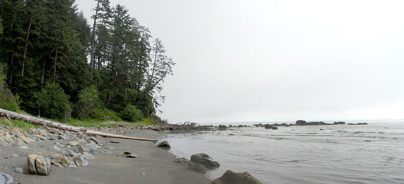
The first part of the hike was simply walking on the firm, low-tide sand. It was easy hiking, and it was fun to see our reflections in the thin layer of seawater that slowly flowed across the surface of the sand.


After a mile and a half of sandy beach, we passed another Beach Access Trail and continued onward. The map warned us that the tide had to be below 7 feet to get by this section, so we weren’t worried at all. The tide was way out there. We turned the corner and found ourselves on some stunning rocky flats. The stone had been carved and eroded into interesting patterns by eons of waves and storms. There were calm tidepools with patiently lurking sea anemones, as well as deep coves filled with forests of kelp.


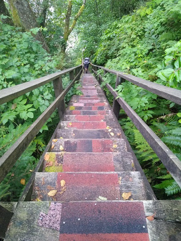
This was on the west side of Carmanah Point, which was just ahead of us. We spied some ladders near the shore, and realized that the lighthouse must be way up there above us. So we headed for the ladders, and, after climbing a couple of them, we were pleased to discover an actual staircase that enabled us to climb the rest of the way up to the lighthouse grounds.
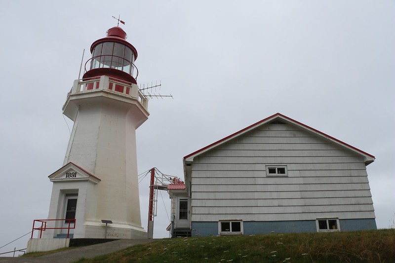
The Carmanah Point Lighthouse was built in 1891, and was now an historical landmark. Unlike the Pachena Point lighthouse, which still had the original Fresnel lens, this one had a modern electric lamp up in the cupola. As expected, the grounds were impeccably maintained by the keepers. They even had most of a whale skeleton lying on the ground nearby, and we had to marvel at the determination of the folks who carried the bones all the way up there.
We didn’t linger long. A woman came out of the keeper’s house and headed our way. I tried to strike up a conversation with her, but it wasn’t much use. I get the feeling that she didn’t like visitors very much, as she pointed to the trail entrance and informed us that this was the way to keep hiking. She did that two times. We began to get the hint. I was a bit shocked. She was the first rude and/or unfriendly Canadian I’d met! And she really wasn’t all that bad, in truth, but the rest of the people up there were so unfailingly nice that she made for quite the contrast. In conclusion, it may well be that there is at least one rude Canadian in existence. We, being friendly Americans, decided to take the High Road. We finished checking the place out, then made it a point to smile and wish her a great day.
We headed for the trail, where we discovered a corny sign letting us know which way to go. And then we headed down the 200 feet of ladders to the beach.


After a short walk along the misty beach, we came upon the Chez Monique’s Burger Place, but it was closed. We’d read that Monique had died recently, and although her daughter wanted to take over the operation (hikers are quite hungry for burgers!) she wasn’t considered to be First Nations, and so she was having some difficulty. But it appeared that someone else was taking up the mantle, so future hikers may yet have a chance at a tasty lunch on the trail.


After that, we arrived at Carmanah Creek, where there was a cable car. It looked like a very long pull, so we headed over to the creek and checked out the water flow. It was mellow enough, and the bottom was sandy, so we put on our water shoes and waded across. Then we stopped and dried off our feet before putting our hiking shoes back on. We also took a pleasant break. We had no burgers, but we had some lunch anyway. There was an official campsite at this creek, but we didn’t check it out up close. While we were there, another group of four decided to take the cable car. We got to watch them doing it, and we had to admit that having more people in your group was very helpful, since there were more hands pulling on the rope.

Video of another group using the cable car


We continued down the beach, which changed to rock flats near a small point of land, then changed back to beach again, but this time it was a beach made of loose gravel, and the hiking was more difficult. Our feet were really sinking into this type of beach, even down by the waterline where it was “wet”, and it became a major slog-fest.


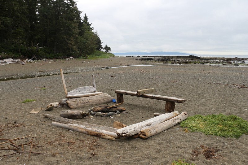
We came to the campsite at Bonilla Point and stopped briefly to check it out. It was small, but seemed really nice. It didn’t look like a lot of people used it, which was a plus in our book. And it had two great things: A very friendly campfire ring with driftwood logs to sit on, and a small but pretty waterfall just around the corner on Bonilla Creek.

Video of the waterfall on Bonilla Creek at the campsite
After we crossed the creek, we continued along the shore. There were occasional sections with solid rock underfoot, which made hiking a dream, but there was an awful lot of slogging sections through the gravel. The tide was coming in, and there was no longer a way to walk along the firmer sections of beach near the water. It also didn’t help that the sun was finally burning through the marine layer, which caused us to sweat profusely in the humid air as we slogged. This got old really fast. But we had to slog on.


Three endless kilometers of slogging after Bonilla Point was Vancouver Point. We stopped there for a boot-off break, to let our feet cool off in the breeze. Vicki was exhausted and overheating, and thoroughly sick of loose gravel. So we got out the map and checked out our two choices. We could use the beach access ladder up to the forest trail which would take us to a cable car over the creek. If we stayed on the beach (for another two kilometers) we’d have to wade across it. If it was too fast and/or deep to wade, then we’d have to walk all the way back. In general, we liked the beach better than the forest, with all its ladders and mud. But this slogging was killing us, and we didn’t know if it would continue beyond the point. I let Vicki make the choice, and she opted for the forest.
I think she made the right choice, but the trail turned out to be just as difficult as we’d expected. It needed a lot of work, as it wasn’t heavily used and had fallen into disrepair. In fact, the very first ladder was rotted and was missing two steps! This was the only ladder we saw like this on the entire trail. And then we came across the usual mud and rickety wooden walkways, but we were used to them by now. As we got closer to Walbran Creek, we met up with a First Nations trail crew who were actively building new walkways. They were doing a great job. We talked with them for a while. They had to airlift huge bundles of milled lumber by helicopter in order to make these walkways, and each section was custom made to fit the terrain of the trail. We thanked them for their service, and headed onward to the cable car. Just as we got there, another group caught up to us from behind, and we worked together to pull ourselves (and them) across the river. This was seriously easy, and a lot of fun. We were glad we took the forest trail.


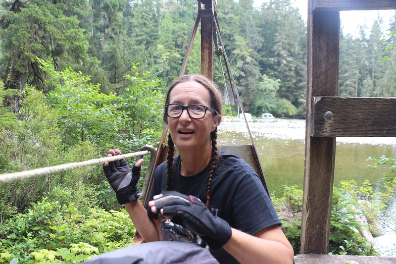
Video of us crossing Walbran Creek in a cable car
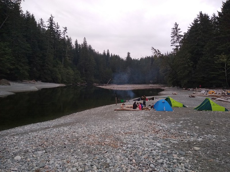
Vicki was quite relieved when we could see the camping area just down the creek near the ocean. It had been a very long and tiring day of hiking. So we shouldered our backpacks and headed down there to find a spot. It was already quite crowded. We may have left camp early that morning, but we certainly didn’t arrive early. I was ready to settle for a lousy spot just inside the forest when Vicki discovered a small spot hidden in the giant driftwood logs at the far end of the campground. It was right on the rocky beach, and there were no other spots close by. Perfect!


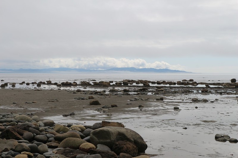
We set up the tent, then headed back to the creek to filter some water. We made sure that we had enough for tomorrow’s hike, because we wanted to get started right away in the morning. Then we ate dinner and watched a whale playing in the kelp. We could see the Olympic Peninsula across the way, and I was able to get cell phone signal from the U.S. towers, which was perfect. I sent some photos to family and friends. Life was good.


After dinner, Vicki headed off looking for the family that helped us cross the creek on the cable car. They were planning to have a campfire, and Vicki wanted in on it. She helped them wander the beach in search of driftwood, which was the only firewood allowed by the park’s rules. At dusk, she came back to camp to get me. I was wondering where she went! But this is normal for Vicki, so I wasn’t too worried. Then we hung out by the fire for awhile, talking and laughing. Although the two of us usually seek solitude, it’s sometimes fun to meet new people on the trail.

Eventually, we headed back to the tent, and proceeded with our nightly ritual: The reading of the trail guide and studying the map. Today had been almost all beach hiking, which we loved, but tomorrow the trail would stay entirely within the forest, as there were surge channels and impassable headlands along the shore. We were in for nine kilometers of mud and walkways and bridges and ladders, and there was nothing we could do about it. Except enjoy it thoroughly, of course!
For a topographic map of the hike see my CalTopo Page
For LOTS more photos of the trek see my Flickr Page
 << Back to Day 4 Onward to Day 6 >>
