Day 4: Nitinat Narrows to Cribs Creek
We hiked from our rented cabin at the Nitinat Narrows Crab Shack to the Cribs Creek Campground via both forested and beach trails. It was a nine kilometer hike according to the trail brochure, but my GPS said it was over 7 miles. I’m not sure why it was so different, but it doesn’t matter much now, as it turned out to be a fun day of hiking.
We woke up at first light and checked out our laundry which was hanging on a rack over the wood stove. It was still soggy, and it was too chilly outside to wear it. We also had about two hours before the crab shack opened for breakfast at 9-ish. So I went outside and chopped some kindling, and we got a good strong fire burning in the stove. We lowered the clothing rack for maximum radiated heat, and waited as the cabin warmed up. Soon it was roasting inside, and Vicki and I were sweating while wearing almost nothing. We read our books and waited, getting up to check the laundry. Within an hour, the most important items were dry, and we were able to get dressed in our hiking clothes. We opened the doors and windows to get some fresh air on the still-soggy clothes, and began packing our gear.
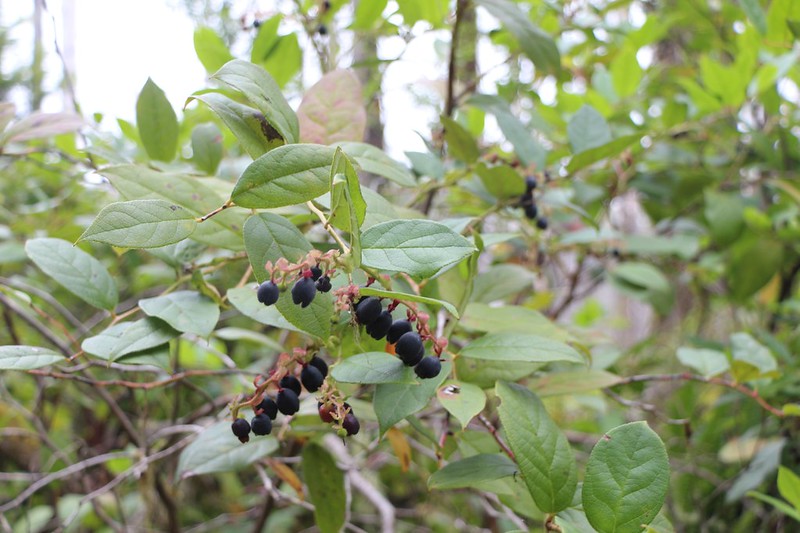
After that, it was time to head down the hill. We ordered breakfast burritos, and they were quite tasty. We sat by the wood stove and ate them while checking out the family’s photo albums and reading some books on edible berries. This was the civilized way of starting our hiking day.


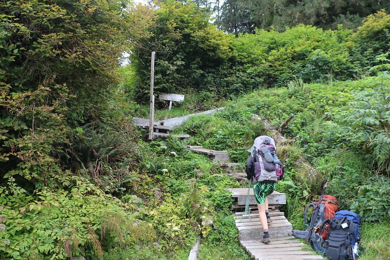
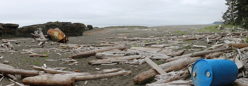
We didn’t start hiking until 10am, which was ridiculously late compared to normal, but we didn’t really care. We started out in the forest, and it was quite beautiful and peaceful. There were boggy lakes, new wooden walkways, and muddy boggy sections to pick our way through. We also tasted some of the edible berries that we now knew all about. There was even a Beach Access Trail out to a cove where we discovered an old rusty shipwreck.


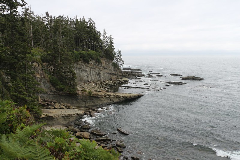
After that, the trail hugged the shoreline while remaining in the forest above the beach. We were treated to some fine views out over the ocean, and had fun hiking on the usual bridges and ladders and mud and roots. We came upon several old abandoned homes at Clo-oose Bay, and took a break on a bench overlooking the beach. This area belonged to a First Nations tribe, and we wondered why the homes were vacant. It’s a mystery we never solved.


Soon enough, we came upon the long suspension bridge over the Cheewat River. We had been warned by the trail guide book not to try drinking water from this river. Not because it was poisonous, but simply because it tasted terrible. There was a small, well-marked spring for thirsty hikers, but we had plenty in our packs.


GoPro panorama video from the center of the suspension bridge over the river

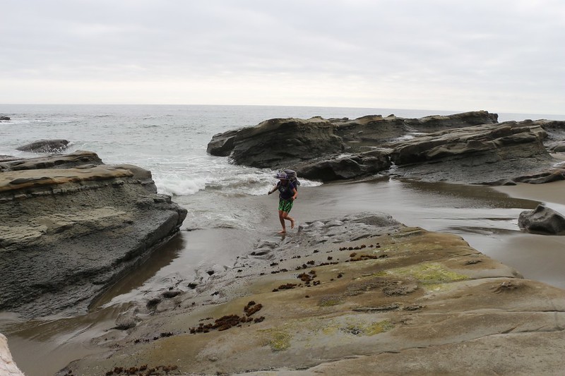
After the bridge, the trail led us out to the beach, and it was beautiful. The sand was fine and soft, without the usual rocks and gravel, and the waves were breaking gently on the shore. Vicki decided to take off her shoes right away, as her feet had been getting hot. She walked right out into the shallow water and almost jumped back out as it was quite cold. But it also felt really good. So she decided to be brave and get used to the water regardless. Soon she was hiking barefoot with a full backpack. This was a unique experience. She tried to get me to join her, but I declined. But I have to admit that I was tempted.


Video of Vicki hiking barefoot on the beach

Sadly, the sandy beach only lasted for a kilometer or so. All too soon, she had to dry off her feet and put the hot boots on. Then we headed back into the forest, as we had to get around Dare Point, which was impassible along the shoreline. And that meant more ladders, and more mud, and more bridges and wooden walkways. Fun!


The trail climbed up high and went past Dare Point, which we had to agree looked quite impassable. But the views were really nice when the trail neared the edge of the coastal bluff.


After that, we headed downhill to the beach once again. The first thing we saw was a set of fresh bear tracks! And they were heading the same way as us, which is always a bit disconcerting. We stared around, looking to see if the bear was nearby, but it was keeping a low profile. We figured that it would probably be visiting the Cribs Creek Campground that night, so we vowed to be extra-cautious with our food, and be certain to store it in the bear locker.

Once again, Vicki decided to take off her shoes and enjoy the soft sand and the cool water. She hiked on the beach as long as she could, which wasn’t very far, until we reached some unfriendly rocks, and then we took another break while she dried her feet and put the shoes back on. I think we spent more time fussing with taking the shoes on and off than we did hiking, but Vicki still insists that it was worth it. So I guess it was.

We were on the final stretch after that. We clambered over some rocks near a small point of land, then arrived at the long straight shoal known as the Cribs Rocks. Almost all of the rocky areas so far had been flat, with tidepools and seaweed that were exposed at low tide, but the Cribs Rocks were quite different. They were at a low angle, such that the waves would wash up the slope of the rocks, then cascade down the steep upper side. These rocks mostly stayed out of the water, but it was obvious that at high tide they got submerged occasionally, because we saw some tidepools on the top. And they were fun to hike on, with good traction and enough bumps and cracks to keep the route-finding entertaining.


As we neared the campsite, we climbed down off the rocks and headed across the sandy flats behind them. There were quite a few tents already set up, and even a campfire was lit. We checked out the bear box and the latrine, and said hello to our new neighbors. It was still early, so we decided to try and find a less crowded area. We knew (since our first night on the trail) that if we picked an isolated spot now, by sunset there would be a bunch of late arrivals who would set up their tents right next to ours. So we continued onward, and crossed Cribs Creek (which had a destroyed bridge) by carefully finding a path over the shallow water. We climbed up onto the sand dune and discovered a whole bunch of really nice camping spots! And we were the only ones over here. This was perfect.


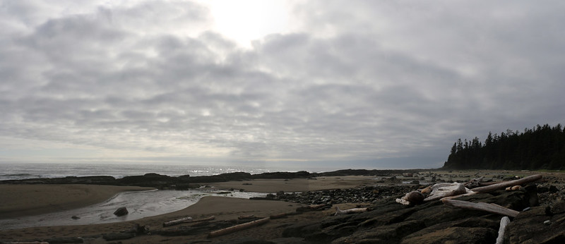
We set up the tent, purified two gallons of water, and ate our dinner. The usual routine. While we ate, we looked out over the ocean. There was a small island out there, completely covered with sea lions. We could hear them barking, and every so often, when the wind shifted direction, we got a whiff of them, too. Phew! Sea lions stink. We prayed for favorable breezes. Then we packed up all the food and headed back across the creek to the bear locker. It was worth the extra walk to have a campsite by ourselves.

It was still fairly early, so we took a post-dinner walk along Coal Creek, and boulder-hopped our way back to the Cribs Rocks. Coal Creek and Cribs Creek joined together here and flowed through a crack in the rocks. Later that night, when the tide came in, we could see that this area would be mostly underwater. Then we double-checked that our campsite would remain high and dry. We’d read in the guide book that, every single year, there were people who woke up very sad as the waves started flooding their tents!

Panorama video at sunset from our campsite

As the clouds formed overhead for the night, the air grew cool, so we headed into the tent. We took out the map and I loaded up the Blisters and Bliss trail guide on my phone. We were at the halfway point of our trek, and we needed to go over our plan, as I had left the choice of campsites open-ended the next two nights. We decided to head for Walbran Creek tomorrow, and it looked to be a fun day of almost continuous beach hiking. That’s the way we liked it.
And then we headed off to sleep, with the sound of the surf and the distant barking of sea lions in our ears.
For a topographic map of the hike see my CalTopo Page
For LOTS more photos of the trek see my Flickr Page
 << Back to Day 3 Onward to Day 5 >>
