Day 6: Walbran Creek to Camper Bay
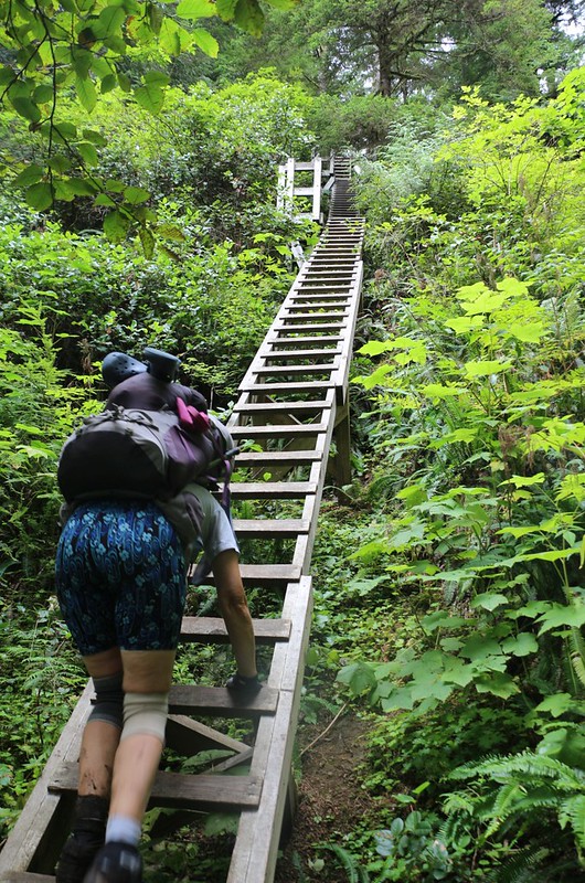
We took our time waking up that morning, which may have been a mistake. We had a long day of hiking in the forest, and The West Coast Trail was notorious for crazy trail-building, so it would probably take us a lot longer to hike the nine kilometers than we expected. “Oh well,” we said to ourselves, as we ate our breakfast and packed up our gear in the chill morning air. And then we began the hike. Right away we realized that it was going to be an interesting day: We had to climb 250 feet up a long series of ladders leading out of Walbran Creek. We certainly warmed up rapidly!


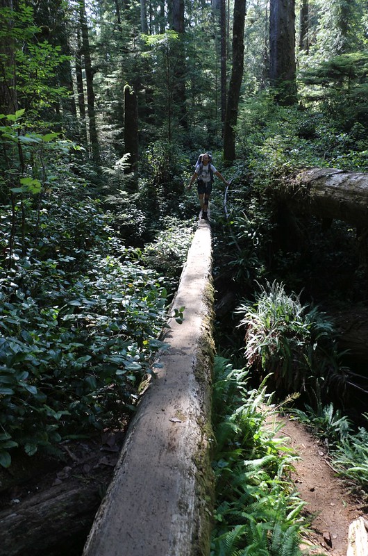
After climbing up onto the plateau, the trail continued through the forest for the next 3 km, and we had plenty of fun on the trail. Lots of ladders and logs and walkways to hike on. Some of the trail was simply on the dirt, and some was through mud. We were really enjoying the Pacific Northwest rain forest, as it was so lush and green, so unlike the forests in California that we were used to. But we couldn’t imagine trying to get through this terrain by bushwhacking. The vegetation was so dense that you could barely see the ground beneath the bushes. When it was ground at all, that is, and not a rotting pile of fallen branches, or a pool of murky water.


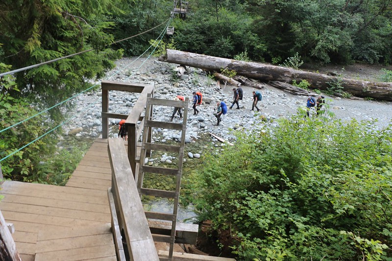
At the 56 km marker, we came upon one of the highlights of the West Coast Trail: The Logan Creek Suspension Bridge. 75 meters long, it crossed a canyon high above Logan Creek. It is held up by two inch-thick steel cables, from which a narrow wooden plank is suspended. There is some comforting woven mesh between the cables and the planking so you never really feel like you could fall. But it sure is high up above the creek bed! The bridge was about halfway down the cliffs on the side, so there were ladders going down initially, but then more ladders climbing back up at the end. One of the ladders on the far side was extremely sketchy-looking (but was quite solid in actuality) as it headed sideways up the cliff. If you fell off that thing you would surely die. Of course, there were no handrails whatsoever, so we held on for dear life and made it up to the top. What a cool bridge! We really enjoyed it.


GoPro panorama video from the middle of the bridge


GoPro video as I walk across the bridge


GoPro panorama video from the ladders on the east side of the Logan Creek Bridge

We took a break up on the top and checked out the huge cables and footings for the new suspension bridge they were building. It was going to cross up at the top of the canyon, and be 113 meters long. According to the parks website, it would be ready for use by the 2020 season. But we had our doubts, as there was nobody working on it, it was already mid-August, and it only had the footings and two cables installed thus far. But it was a major undertaking, building something that difficult, way out here in the middle of nowhere. In a way, I’m glad we got to cross on the old bridge.
After that, we continued on through the forest. One section of trail went across a flat, sparsely-treed, swampy region, and it was (thankfully) composed almost entirely of wooden walkways. Except for two notable spots, where the walkway had rotted away and there was liquid water overlaying mud of unknown depth across the path. I was able to make my way around the edges by carefully stepping on various roots and branches, but Vicki wasn’t so lucky. Her boot slid off a slippery log and splash! her foot went down, deep into the mud. Her hiking stick sunk about two feet into the glop and caused her to get even more off balance. Her other foot also got a bit of a dunking. Her feet and boots were soaked, and the expression on her face was one of utter disbelief. It had all happened so fast! But, no, Vicki, it wasn’t a dream. And there was no place to stop in the middle of a bog to wash off the stinky mud. I checked the map, and Cullite Creek was only a short ways ahead. We’d take a big break there, and get her all fixed up.


After that, the remaining muddy sections of trail held no fear for Vicki. She stomped right on through them. Meanwhile, I tiptoed around the edges, carefully keeping my boots dry.

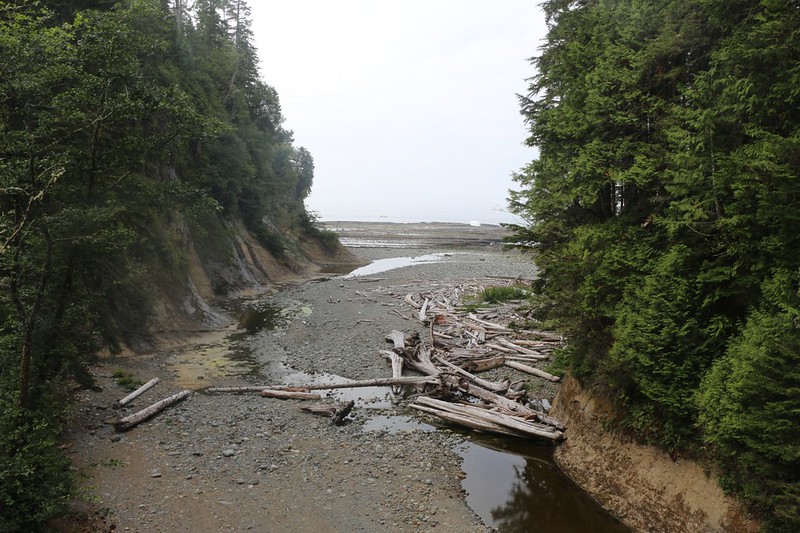
We finally made it to Cullite Creek, where there was a long series of ladders that descended about 200 feet. At the bottom was a cable car, but we didn’t need to use it as the water was flowing slowly. I rock-hopped across and Vicki stomped right into the deeper sections of the creek to help loosen the mud on her shoes. We headed down the creek toward the ocean and the small campground at the beach. It was a really great campsite, in it’s own private little cove, and we were a bit sorry that we wouldn’t be staying there overnight.


We set down our packs in the campground. I got out our lunch while Vicki got out her water shoes. She headed over to the creek and did her best to scrub the stinky bog-smelling mud off her boots. She rinsed out her socks and scrubbed the dried mud from her legs. Then she put on the water shoes and came back to camp for lunch. After eating, she took a long nap on the driftwood logs near the fire pit on the beach. When she woke up, she put on her pair of SealSkinz waterproof socks, which would keep her feet dry inside the soggy boots. The boots would have to dry out as she hiked.


Then it was time to make the long climb up and out of the Cullite Creek canyon. Lots of ladders. But we were well-rested and full of new energy, which made it fun. We were just beyond the halfway point, and had four more kilometers left to hike, all of it in the forest. There was a big solid bridge over Sandstone Creek, and a lot of crazy trail after that, with boggy mud pits, and carved logs, and oddball ladders.


This time, we were glad to discover that our path led down along the cliffs above the beach, and we got a few views here and there. It was nice to hear the sound of surf while we hiked. We also got to stop for extra breaks with a great view. At one of them, Vicki took another nap with her shoes drying in the sun, while I texted some photos to family and friends back in the USA.

Panorama video from the viewpoint

After that, we only had two kilometers to go, and we hoped to make decent time through the woods. But it turned out that the trail climbed and climbed as it headed inland again. We kept hiking slower and slower.
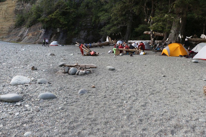
The highpoint of our day’s hike was at 370 feet elevation, and that was where the trail finally turned right and headed down a long slope to Camper Bay. The forest here was light and airy, and was truly a pleasure to hike through. Eventually, we headed down a few last ladders and arrived along the shore of Camper Creek, where there was a cable car. But we didn’t need it yet, as the campground was on this side of the water.

When we arrived at the campsite we discovered that we were almost the last people to arrive. Everyone else got all the good spots up under the trees, or that had their own private fire rings. We had absolutely nothing, so we headed over to the wall of the canyon and set up our tent nearby. The sun didn’t shine down into there that late in the day, so it was already getting a bit cool. We got in the tent and put on our night clothes right away.

Then we headed off, upstream, to filter some water from the creek. We checked out the cable car and realized that we probably wouldn’t need it in the morning, as there were plenty of big rocks to hop on. Then we headed back to camp and ate dinner.

We didn’t stay up very long that evening. We checked out the map and the tide tables, and it looked as though we might be able to make it around Owen Point along the beach route if we started out super early. It required the tide to be below 6 feet to get around the point, and this was the lowest tidal requirement on the entire trail. So we set the alarm for 4am, and went to sleep.
All in all, it had been a really fun day. Except for Vicki’s soggy boggy feet, of course.
For a topographic map of the hike see my CalTopo Page
For LOTS more photos of the trek see my Flickr Page
 << Back to Day 5 Onward to Day 7 >>