Day 6: Chapel Creek to Mosquito River

We did a ten mile loop dayhike on the North Country Trial through the most scenic section of Pictured Rocks National Lakeshore, from Chapel Creek to the Mosquito River, visiting Chapel Rock, the Grand Portal, and Lovers Leap, as the trail stayed along the edge of the sandstone cliffs, providing stunning views of Lake Superior.

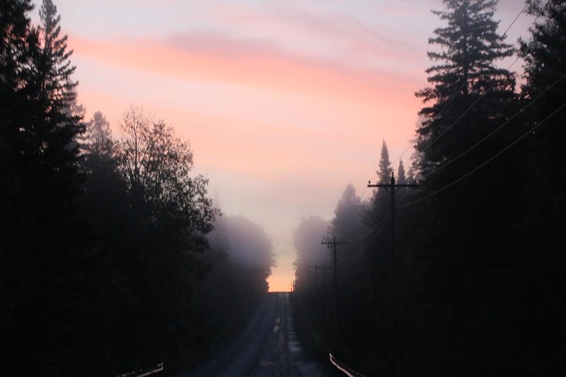
We knew that it was going to be a long day, so we left our friend’s house before dawn and drove to the trailhead.  We were happy that this was a loop hike, so we didn’t need to ask for a ride, for once.

Foggy sunrise on Highway H-58 as we head into Pictured Rocks National Lakeshore for our final hike
Foggy sunrise on Highway H-58 as we headed into Pictured Rocks National Lakeshore for our next hike
Vicki getting ready to hike at the Chapel Falls Trailhead in Pictured Rocks National Lakeshore
Vicki getting ready to hike at the Chapel Falls Trailhead

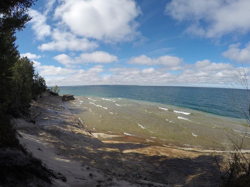
We decided to hike down to the shore on the Chapel Beach Trail, since we’d already hiked up the trail to Chapel Falls.  The two trails differed mainly by which side of Chapel Lake they were on, as both arrived on the beach in almost the same spot.  We liked the idea of seeing more of this lovely park by taking a different path.  This time, the views of Chapel Lake and Little Chapel Lake were much better than on the falls trail, so we were happy.

Morning in the maple forest on the Chapel Beach Trail at Pictured Rocks National Lakeshore
Morning in the lush maple forest on the Chapel Beach Trail
Chapel Lake with Autumn colors from the Chapel Beach Trail in Pictured Rocks National Lakeshore
Chapel Lake with Autumn colors
View over Little Chapel Lake at dawn from the Chapel Beach Trail in Pictured Rocks National Lakeshore
View over Little Chapel Lake at dawn

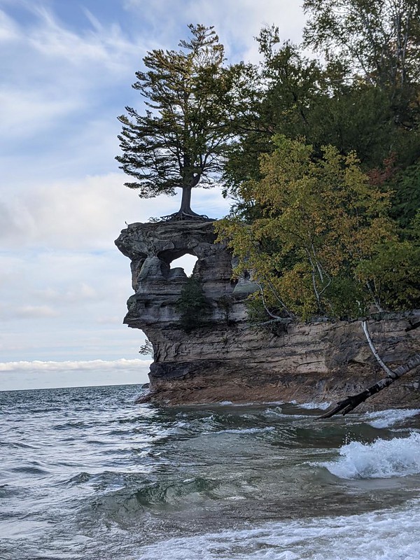
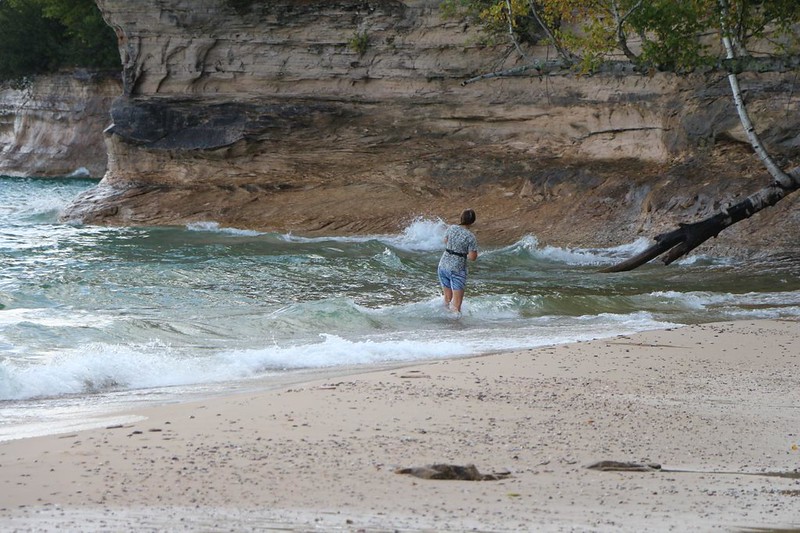
It was still early morning when we arrived at Chapel Beach.  Vicki immediately took off her shoes and waded across Chapel Creek, trying to get closer to Chapel Rock for a better picture and/or novel perspective.  Or maybe she simply wanted to freeze her feet!  She got her photo, and that’s what matters most.  She also took advantage of an opportunity to walk barefoot along a sandy beach.

View of Chapel beach from the North Country Trail in Pictured Rocks National Lakeshore
View of Chapel beach from the North Country Trail
Chapel Creek and the footbridge (with Vicki) from Chapel Beach at Pictured Rocks National Lakeshore
Chapel Creek and the NCT footbridge (with Vicki, for scale)
Vicki wanted to get closer to Chapel Rock so she took off her shoes and waded across Chapel Creek
Vicki's shot of Chapel Rock from Chapel Beach on the shore of Lake Superior in Pictured Rocks National Lakeshore
Vicki’s shot of Chapel Rock from within the surf of Lake Superior
Vicki wading in Lake Superior, trying to get a good photo of Chapel Rock, in Pictured Rocks National Lakeshore
Vicki wading in Lake Superior, trying to get a good photo of Chapel Rock

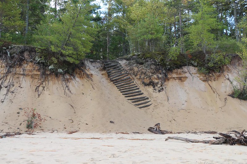
We eventually climbed up the sand ladder at the west end of the beach, and Vicki had to don her shoes once more.  She didn’t regret a thing.  Walking on the beach with your bare toes is almost always enjoyable.

The sand ladder shifted a bit during the rough Winter on Lake Superior on the west end of Chapel Beach
This sand ladder shifted a bit during the rough Winter on Lake Superior
Vicki stopped to put on her shoes after walking barefoot on Chapel Beach - now to start some serious hiking!
Vicki stopped to put on her shoes after walking barefoot on Chapel Beach – now to start some serious hiking!

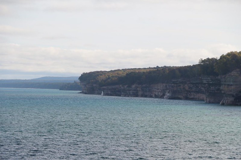
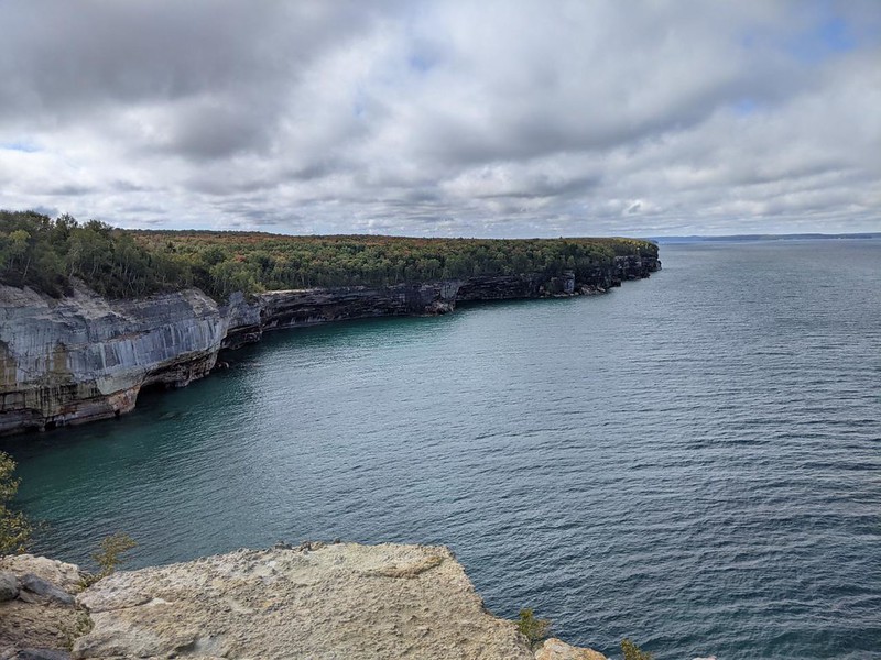
After the beach, the North Country Trail climbed upward until it was running along the tops of the sandstone cliffs, many of which were severely undercut by wave erosion.  This is what we were waiting for!  Stunning views and small-but-measurable danger!

The first stop was along the “Hidden Cove” that the big catamaran tour boat had pulled into on our first day here.  We wandered all around it, trying to get the best photo, even if it meant holding on to scrawny tree trunks while leaning out over the water with my GoPro.  If I had fallen in, I likely would have died of hypothermia while trying to swim around the cove to the beach.  But I didn’t.  I’d hate to be one of those statistics you always read about.  I came to my senses afterward and vowed to take fewer risks in the future.

GoPro view of Hidden Cove where the big tour boats pull inside, at Pictured Rocks National Lakeshore
GoPro view of “Hidden Cove” where the big tour boats pull inside
Vicki took a photo of me with my GoPro as I leaned out over the edge of the cliff in Hidden Cove

After that, it was time to hike along what the tour boat guide called “Battleship Row,” a set of shallow coves and  points that tended northwest from the beach.  The points gave us many opportunities to take photos of the nearby cliffs, and also zoomed-in shots of Chapel Rock and Spray Falls (off in the distant east).  It should be noted that most of the “points” that stuck out into the lake had been undercut by the incessant wave action on Lake Superior.  It should also be noted that you couldn’t tell that they were undercut when you were standing up on top of them!  Yes, we were living the Spicy Life, and we didn’t even know it.

View along the cliff-lined shore of Lake Superior in Pictured Rocks National Lakeshore
View along the cliff-lined shore – the tour boat guide had called this “Battleship Row”
Zoomed-in view east toward Chapel Rock and Autumn leaves in the forest of Pictured Rocks National Lakeshore
Zoomed-in view east toward Chapel Rock, with Autumn leaves in the forest
View east along the Lake Superior shoreline, with Spray Falls left of center, from the North Country Trail
View east along the Lake Superior shoreline, with Spray Falls left of center
The North Country Trail mainly runs directly along the edge of the sandstone cliffs in Pictured Rocks National Lakeshore
The NCT often runs along the edge of the cliffs in this part of the park
I'm probably standing on a totally undercut cliff that might collapse at any moment - but I got a great view!
I was probably standing on an undercut cliff that might collapse at any moment – but I got a great view!

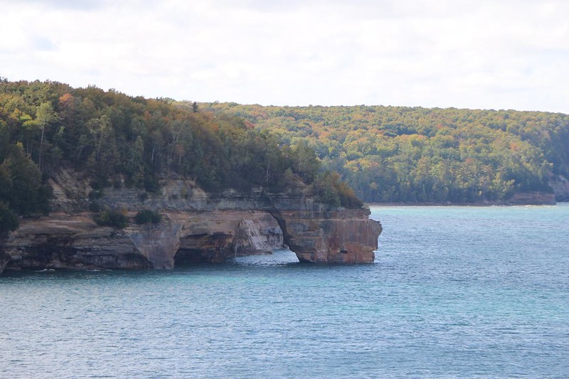
Our next stop was Grand Portal Point, a large natural bridge, or arch, that jutted out into the lake.  It was worthy of many photographs, and we didn’t hesitate to stop and take them as we hiked along on the trail.  This was surely one of the most picturesque sections of the park that we had seen thus far.  We were having a great time!

View of the Grand Portal and Lake Superior from the North Country Trail in Pictured Rocks National Lakeshore
View of the Grand Portal as we hiked west on the NCT
Zoomed-in view of the Grand Portal, a natural bridge over Lake Superior, at Pictured Rocks National Lakeshore
Zoomed-in view of the Grand Portal, a natural bridge which had partially collapsed
View northwest along the coast toward Grand Portal Point from the North Country Trail at Pictured Rocks NL
View northwest along the coast toward Grand Portal Point
Me taking a GoPro video and holding on to a small tree so I don't fall off the cliff into chilly Lake Superior
Me taking a GoPro video and holding on to a small tree so I wouldn’t fall off the cliff into chilly Lake Superior
GoPro view looking down at collapsed cliff rubble, with the Grand Portal on the far left, from the North Country Trail
GoPro view looking down at collapsed cliff rubble, with the Grand Portal on the far left

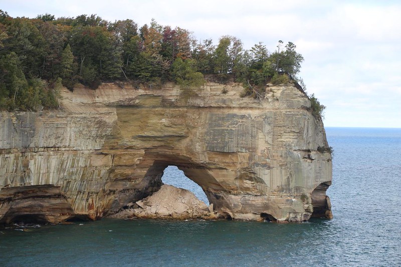
The Grand Portal was at roughly the halfway point of our day’s hike, so we stopped up on top to take a major rest break.  Naturally, it was impossible to see the Grand Portal from up there, but we knew it was down below us.  The likelihood of a major collapse seemed quite low, so we didn’t really mind hanging out up there.

There is a huge viewing area on top of the Grand Portal at Grand Portal Point, at Pictured Rocks National Lakeshore
There is a huge resting/viewing area on top of the Grand Portal at Grand Portal Point
Vicki took a short nap out on the overhanging sandstone cliff at Grand Portal Point in Pictured Rocks National Lakeshore
Vicki took a short nap out on the overhanging sandstone cliff – sleeping in exotic places!

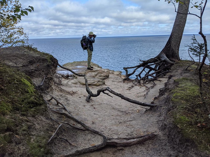
We continued on around the corner to the west, following the cliffs on the NCT.  This was a great trail.  It didn’t mess around.  It mainly stayed safely back from the edge and but there were enough side-paths to the clifftops that it let you enjoy selected viewpoints with only mild danger.  It was also fun to listen to the waves as they thunked and galunked far below, the sounds resonating in overhanging hollows underneath the cliffs.  We also found yet another great spot to take a long break, and so we took one.  Why not?  It was beautiful up there.

View west over Lake Superior at the colorful sandstone cliffs of Pictured Rocks National Lakeshore
View west over Lake Superior at the colorful cliffs of Pictured Rocks National Lakeshore
We took a long break at another viewpoint west of Grand Portal Point and simply enjoyed the views over Lake Superior
We took a long break at another viewpoint and simply enjoyed the views over Lake Superior

We saw our first tour boat not long afterward.  Conditions were peaceful on the lake once again.  We waved at the people on board, but only some of them noticed us up here.  They were all too busy looking at the cliffs, not the tiny ants perched on top.  We also got limited cell reception as we rounded the corner, and we sent a few photos off to friends and family.  That’s what cell phones are good for, mainly:  Communicating how jealous they should be of us while they were stuck at work.

The catamaran tour boat goes slow when there is a point of interest along the cliff-lined shore of Lake Superior
The catamaran tour boat goes slowly when there is a point of interest along the cliff-lined shore
Zoomed-in view east at the viewpoint where we took our long break, in Pictured Rocks National Lakeshore
Zoomed-in view east at the viewpoint where we took our second long break

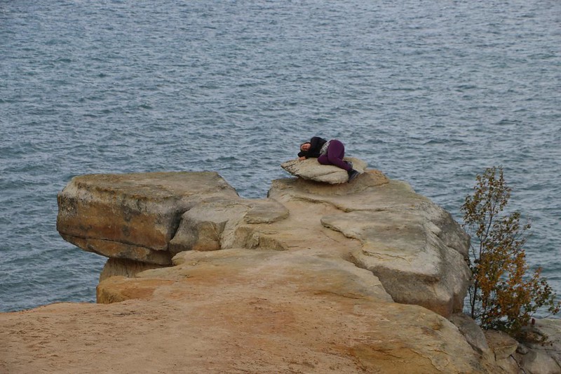
There was plenty of clifftop hiking in our future, but I can’t show photos of all of it.  You’d get bored.  But the next big feature of the park was coming up:  Lover’s Leap.  And I will be happy to share photos of that fantastic arch.  Unlike the Grand Portal, this natural bridge had no obvious debris beneath it, just clear blue lake water.  I’m hoping that it was given this interesting name strictly for romantic reasons, and that lovers really hadn’t jumped off the top of it.  I checked with the park, and the official name of this feature is “Petit Portal,” so it sounds like somebody got romantic.  I’m thinking that it might have been the boat tour operators, or maybe the commercial kayak guides.  The NCT went right by, and there was a side trail out over the top of the arch.  We went out there, and of course it was useless, as you couldn’t see a thing from up above.  And leaping would have been utterly unromantic.  But we still got good views from the cliffs on either side.

Zoomed-in view of Lovers Leap, the impressive natural bridge and arch in Pictured Rocks National Lakeshore
Zoomed-in view of Lovers Leap, the impressive natural bridge and arch
Zoomed-in view of Lovers Leap from the North Country Trail in Pictured Rocks National Lakeshore
Zoomed-in view of Lovers Leap
GoPro photo looking straight up into the green leafy canopy of the maple forest in Pictured Rocks National Lakeshore
GoPro photo looking straight up into the green leafy canopy of the maple forest
Vicki took a less-flattering photo of me and Lovers Leap as I try not to leap off the cliff myself!
Vicki took a less-flattering photo of me and Lovers Leap as I tried not to leap off the cliff myself!
Looking east at Lovers Leap, the natural bridge or arch above Lake Superior, at Pictured Rocks National Lakeshore
Looking east at Lovers Leap from a precarious, clifftop viewing spot

It was only another mile or so until we reached the Mosquito River.  That was where we had to leave the North Country Trail and head back toward our car.  So we decided to take one last break on some low cliffs to the east of the river.  There were great views west from there, and the weather was fine.

GoPro view of a sandstone shelf along the shore of Lake Superior east of the Mosquito River at Pictured Rocks NL
GoPro view of a sandstone shelf along the shore of Lake Superior east of the Mosquito River
We were almost back at Mosquito Beach so we decided to take a boot-off break on the sandstone rocks on shore
We were almost at Mosquito Beach so we decided to take a boot-off break on the sandstone rocks

Vicki hates mosquitos with a passion, and she didn’t like the name of the river at all.  But this late in a very dry season, there were no bug issues whatsoever.  This made her feel much happier.  It was almost enough to offset the fact that the Mosquito Beach Trail climbed uphill to reach the trailhead parking lot.

The views were over and it was time to head back to the trailhead on the Mosquito Beach Trail
We made it back to the the Mosquito-Chapel Falls trailhead parking lot after a long ten mile day of hiking - worth it!
We made it back to the the Mosquito-Chapel Falls trailhead after a long day of hiking – totally worth it!

We made it to the car after a ten and a half mile hike, and Vicki’s sore foot wasn’t exactly happy.  Vicki was happy, but not the foot.  It had been a truly wonderful hike, on what could arguably be called the prettiest part of the entire park.  It had also been a magical experience in many ways.  Such extraordinary cliffs and forests, plus the massive lake, all worked together to cast a spell of wonder and delight.

Autumn color on the maple trees as we drive up Chapel Road at Pictured Rocks National Lakeshore - Great Park!
Autumn color on the maple trees as we drove up Chapel Road

After that, it was time to rest Vicki’s foot while I drove back to our friend’s house.  There was now only one long section of the NCT in the park that was left undone.  It was almost fifteen miles long.  I could do it in either one or two days, but either way, Vicki decided that she was done hiking for a while.  Fifteen miles it would be, then.  Unless I couldn’t handle it.  But I’d find that out soon enough.


For a topographic map of the hike see my CalTopo Page

For LOTS more photos of the trek see my Flickr Page


  << Back to Day 5              Onward to Day 7 >>  


Up to “Further Afield”