Day 5 Summary: Layover Day. Day-hiked to Thousand Island Lake on the PCT/JMT via Island Pass (elevation 10205 feet).
All trips should have a Layover Day. Maybe it’s just the sound of the word, but it reminds me of relaxation, of laziness, of selfish hedonism. I was looking forward to a day like that. But did I get one? Of course not. Unless you count spending a day hiking in the High Sierra relaxing!
Layover day or not, our plan was to camp here for a second night, so we didn’t have to pack up our gear, which was a good start. And I probably could have slept late that morning, but I didn’t. I left Vicki all snug and warm in the tent and ventured outside for some dawn photography. I was looking forward to seeing the early glow on the spectacular mountains to our west.
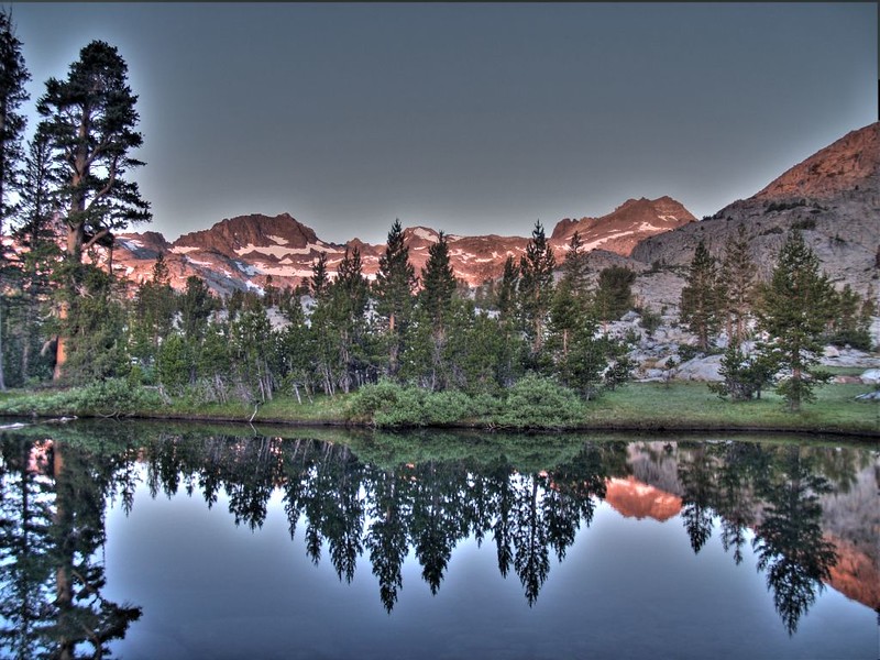

By the time I got back to the tent Vicki was already getting breakfast ready. She’d only been faking all that extra sleeping. Then we found a spot in the sun overlooking a small pond and ate breakfast. Down here in this valley it had been quite cold and there was still plenty of frost on the ground. Brrr!


We ate fast and headed back to the tent. We jumped into the sleeping bag and snuggled for a while to get some warmth back into our limbs. We stayed there until the sun actually hit the tent, and the temperature began to rise enough that we were willing to get into our lighter daytime clothes.
We packed a subset of supplies in our small daypacks and discussed our route for the day while consulting the map. The old abandoned path next to our tent intrigued us. We decided to follow it downhill, where we hoped it would parallel the PCT and eventually join it. We were certainly getting to be much more confident in our cross-country route-finding skills (and also our GPS). After that we’d continue on the PCT heading south. Since the past two days had been stormy, we carefully stuffed the extra clothing and sleeping gear into a plastic bag and set them up higher on the air mattresses, and secured the rest of our gear in the vestibules of the tent. We also made sure to take our raingear with us, just like the day before. Then we started hiking.

Video of the creek as we head cross-country to the PCT

Video of me crossing the creek on a fallen log, a somewhat conventional route.
We hiked down the old trail until it petered out. And then we kept hiking hoping to find it again. It was easy downhill, so we made decent time, but then the slope began increasing dramatically. I brought out the GPS and checked on our progress. I called an immediate halt as I realized that we had been headed gradually further away from the PCT, and in fact were headed directly for Waugh Lake, which we could see down below us. This went directly against Vicki’s philosophy of avoiding pointless downhill hiking which resulted in unnecessary uphill climbing. She agreed with me, and we turned ninety degrees to the right. Soon enough we were safely on the PCT, heading downhill to its intersection with Rush Creek.
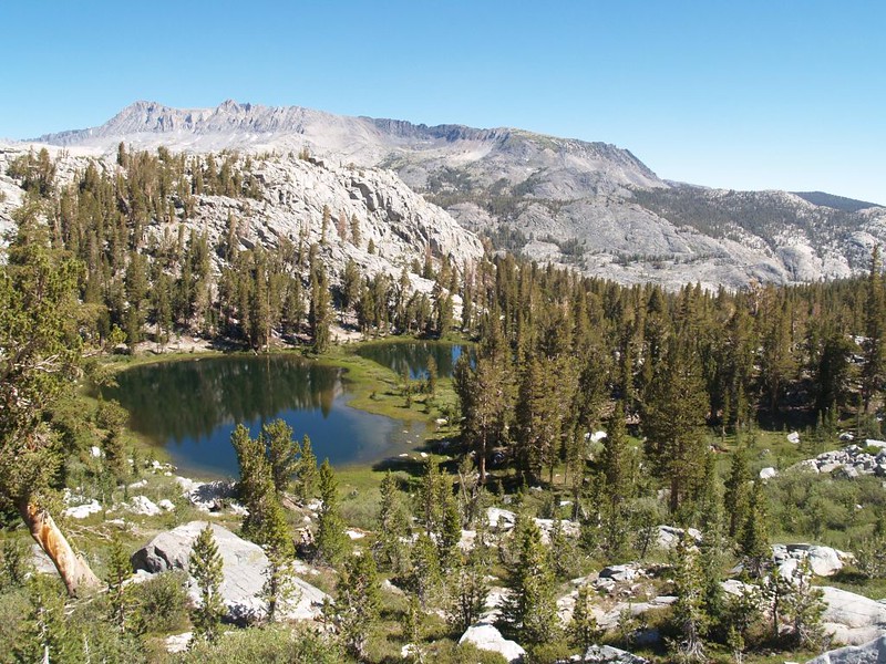
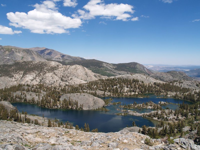
After that, we’d be in store for some “necessary” uphill climbing, as the PCT went over the top of Island Pass. At 10,205 feet elevation, it was only a tiny bit higher than our current campsite, so it was a relatively easy pass. It was also very broad and flat up there. But unlike Gem Pass (two days ago) which had no view whatsoever, this pass was beautiful. It had several shallow lakes, and in the calm morning air the nearby mountain peaks were reflecting off their surfaces. It was so peaceful that we stopped for a break and had our morning snack on some comfy granite boulders.

Video of small trout swimming in Rush Creek

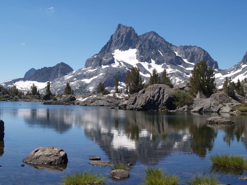

Our primary destination lay just ahead: Thousand Island Lake. We hiked down the PCT looking for an excellent overview spot, but the trail stayed in the trees, offering only partial views of the lake. And that was when Vicki’s aversion to pointless downhill hiking came into play once more. It was less than 400 feet down to the lake itself, but she refused. So we headed off-trail, regaining a few of the feet that we’d already foolishly lost, until we discovered exactly what we wanted: A spot with a superb view. And that’s where we decided to eat lunch, relaxing on some granite slabs with amazing scenery.

Panorama video of Thousand Island Lake

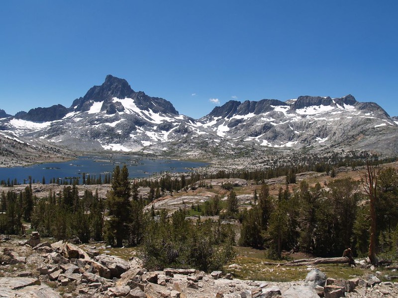
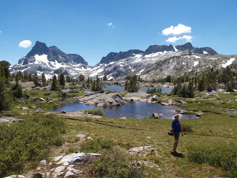
After we ate, I suggested that we head back down to the trail and then head back to camp, but Vicki refused once again. It really wasn’t much pointless downhill hiking at all, I pointed out. But she was having none of it. In fact, what she really wanted to do was even more cross-country hiking. Uphill! She wanted to climb to the top of the ridge and find a spot where she could check out Weber Lake, and maybe even Sullivan Lake. I tried to point out that this would be pointless uphill hiking, as we would have to descend back to Island Pass eventually, but she didn’t care. I tried to argue but eventually gave up. A woman with a map is a dangerous thing. And then we started climbing.
And she hiked uphill just fine. I don’t think she truly realized just how acclimated her body had gotten after spending five days above 10,000 feet. We easily could have descended to Thousand Island Lake, but it was too late now. We made it up to the ridge-top, scrambled around a bit, and found a suitable spot where we could look over toward the north while being able to see Weber Lake down below us. We could also see in the distance the route we’d taken above Waugh Lake. And I hate to admit it, but it turned out that Vicki was right: This was much better than heading down to Thousand Island Lake. I’ll have to remind myself to stop arguing against her crazy ideas in the future.

Panorama video from the high point above Island Pass
After that, it was time to head on home to our cozy tent. We headed cross country back to the PCT at Island Pass, and didn’t lose too much pointless altitude. Or, more precisely, we didn’t notice losing all that pointless altitude, because the views continued to be so excellent. The high peaks in the Ansel Adams Wilderness were truly breathtaking.
Meanwhile, the weather looked to be cooperating with us, as the puffy cumulus clouds didn’t appear to be building up into thunderheads today. Vicki had plans to do some much-needed laundry that afternoon, and we really needed to get them dry or we’d be putting them back on the next morning, soggy or not.
So we followed the PCT north, backtracking on the morning’s hike, descending from Island Pass, crossing Rush Creek, heading back uphill, and getting back to camp with plenty of time to spare.


Video of Vicki skipping downhill on the PCT

Noisy video of Rush Creek rushing downhill

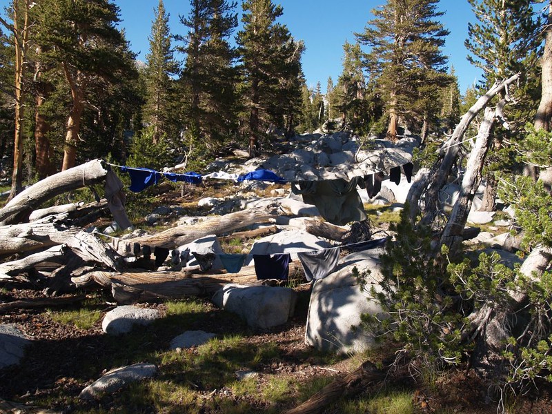
We took a brief rest in the tent and changed into our night clothing. Then it was time to do some chores. Namely: Laundry. Let’s be honest here. You can’t tell from this easy-going story of idyllic forest hiking, but the truth of the matter was that we were getting rather ripe, and our clothes absolutely stank. You can only carry so many sets of clothing when backpacking, to save on weight and space, and we’d been sweating every day. And let’s not even talk about the state of our several pairs of socks. So Vicki got out the soap and laundry tub (a light plastic box that she normally keeps the kitchen gear inside) and started doing laundry the old-fashioned way: One piece at a time, dunking it in the suds, with plenty of elbow grease being used, mushing and scrunging and wringing the dirt out of it. The soapy clothes were piled on a rock, and the next piece was washed. The water turned brown with dust and dirt from the trail. Were we really that dirty? It really was impressive. We changed the water, added more soap, and continued until done. Then it was my turn. We got some rinse water and did each piece again, dunking and squeezing and piling them up. Then another round of rinsing, Vicki’s turn, until the water looked clear. The final wringing-out was my job, as I had more strength, and if we ever wanted to get them dry today I had to get rid of every last drop of water that I could. By the time we were done our arms were hanging down at our sides, limp and exhausted. Then we each dug into our packs and got out our spare rope (eighth inch diameter) and strung some clotheslines in the sun. We hung the laundry, and, luckily for us, a breeze sprang up and started drying everything rapidly. In fact, almost everything finished drying before dark, except for the heaviest socks, which we’d hang on the outside of our packs the next day. Perfect! Meanwhile, we also gave ourselves a cursory sponge-bath, as the pond water was far too cold for bathing, and decided that this would have to do, for now. We sure felt (and smelt!) much better after that.

After all that effort, we wandered around camp and sat by the ponds in the sun. As long as we were there, we filtered more water for dinner, breakfast, and tomorrow’s hike, which is a very peaceful job. And we even read our books in the nice warm tent. Very relaxing, in other words. It finally became a Layover Day, after all!
For more Day 5 photos and videos see my Flickr Page.
For an interactive topographic map including our GPS tracks see my CalTopo Page.


