I hiked uphill on the Piute Pass Trail through clouds of mosquitos, which vanished once I reached sunny Humphreys Basin, after which cumulus clouds built steadily, eventually threatening rain, as I climbed up and over Piute Pass and eastward down to Piute Lake, where I set up my tent just in time to shelter from the rain and hail of a High Sierra thunderstorm. It was a beautiful and exciting day on the trail!
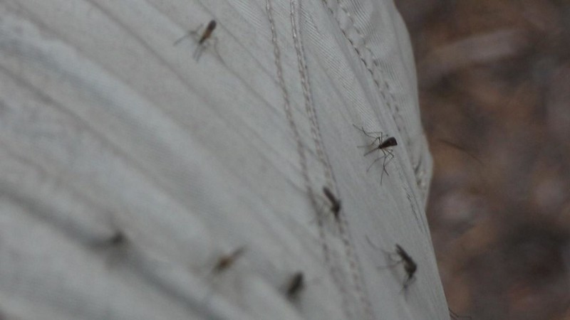
Once again, I woke up in the dark at 4am, and began cooking breakfast in the vestibule of the tent. Cooking in the tent is not recommended by the lawyers of tent manufacturers, so be warned. I liked it because I could keep my legs inside my warm sleeping bag. A few mosquitos entered the tent, even though it was still cold, but I wasn’t worried. After eating, I packed up everything and went outside to take down the tent. That was when the mosquitos came out in force. I paused in order to get out my 100% DEET bug repellent, and put some on my face, neck, and hands. The bugs still buzzed around me while wearing DEET, because they knew that I was tasty, but they refused to land, and that’s what really mattered. I finished packing, and headed out before 6am.

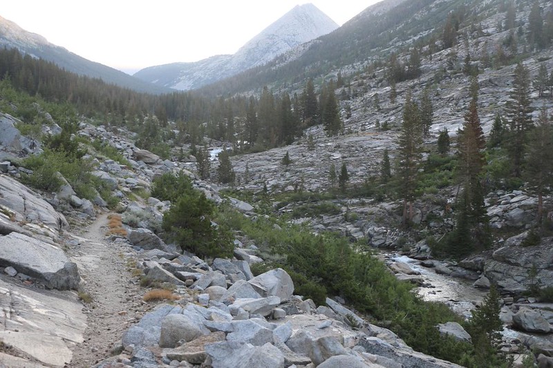
I seemed to be the only one out on the trail that morning, and that was the way I liked it. Enjoying the proverbial Solitude of the Wilderness. The trail headed generally east, steadily uphill, following Piute Creek as it cascaded past, deeper into the valley. I had about 2500 feet to climb to the pass, and I was very glad that I’d already climbed 1000 feet of it the day before. My original plan for the trek had been to spend tonight in Humphreys Basin, then pop over the pass the next day. I was simply a thousand feet ahead of myself, that’s all.
Video of the creek cascading down
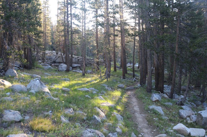
The first thing I discovered that day was that this section of the Piute Pass Trail mostly stayed in a grassy forest, far away from the creek itself. The second thing I discovered was that the mosquitos were not only abundant, but were ravenous, as well! I was the only moving thing in the woods, and they all seemed to know it. Before long, I had a significant cloud of bugs trailing along behind me in my slipstream. The third thing I noticed was that I couldn’t possibly stop hiking, no matter what! If I stopped, or even slowed down, the cloud rushed forward and swarmed my face thickly enough that I could barely see or breathe. I waved my hands wildly at them to no avail. They were ferocious, and DEET barely slowed them down.

All told, I hiked five miles in three hours, uphill all the way, with essentially zero stops or breaks of any kind. I was so happy to find an open spot without any bugs that I sat down and rested for at least twenty minutes. What a morning it had been! Quite the workout! I was almost halfway to the pass and it was only 9am. And I have the bugs to thank for it. I guess. In theory, anyway.
At that point, I was well above 10,000 feet elevation, and was nearing the tree line. Views became more frequent as the trees grew sparse and stunted. I was entering lower Humphreys Basin.

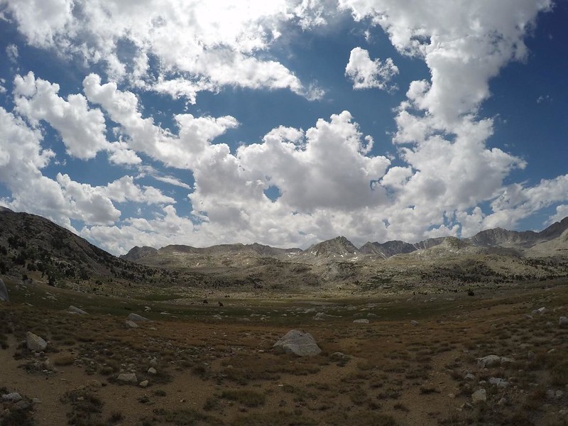
I continued onward. The occasional puffy cumulus clouds of the early morning were no longer “occasional.” The sky cover grew until the blue areas were in the minority. I had a feeling that it might rain today, but I hadn’t seen any weather reports. Just the same, my experience in the High Sierra told me that there would likely be thunder later on this afternoon. Meanwhile, the clouds were improving my pictures immensely. Very dramatic. I got out my phone and started up my PeakFinder app, to identify some of the many mountains that ringed the basin. This is a good excuse for taking a break on a long uphill hike!

GoPro panorama video from lower Humphreys Basin

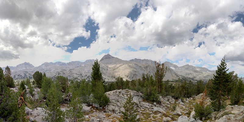
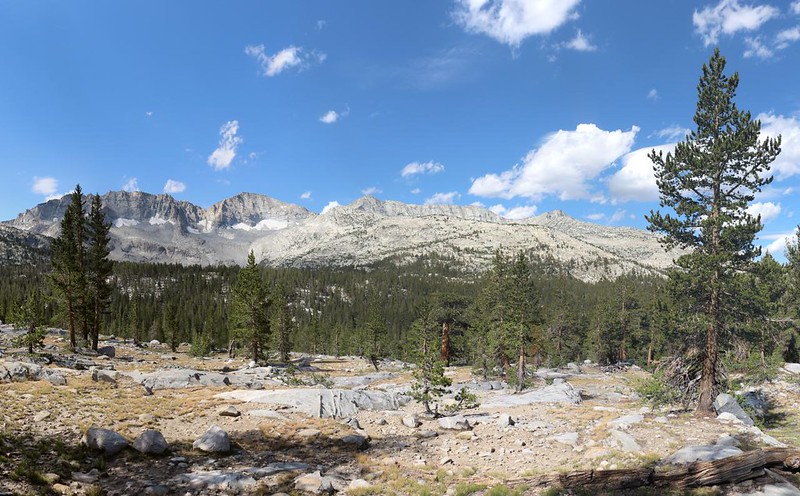
By 11am I had entered Humphreys Basin proper. It doesn’t really count as the basin if you can’t see Mount Humphreys, which dominates the entire area. Four years ago, also in early July, my son and his friend accompanied me over Piute Pass. That year, 2017, had been a record snow year, and the entire basin was still covered in three feet of deeply sun-cupped snow. What a difference this was, compared to 2021, one of the driest years. Although the snow was interesting, it wasn’t much fun to hike on, and I have to say that I was glad that it was already melted this time. Except for the mosquitos, of course.

GoPro panorama video from Humphreys Basin

As I neared 11,000 feet, the trees in the basin were almost entirely gone. This was the land of ice and snow for most of the year. Let’s face it: It wasn’t easy trying to make a living up here. I was glad to be merely a passing visitor, as the snow-free views were getting better all the time. Meanwhile, the clouds continued their steady march to the north, with fresh soldiers following behind them in procession.

Panorama video from the center of the basin

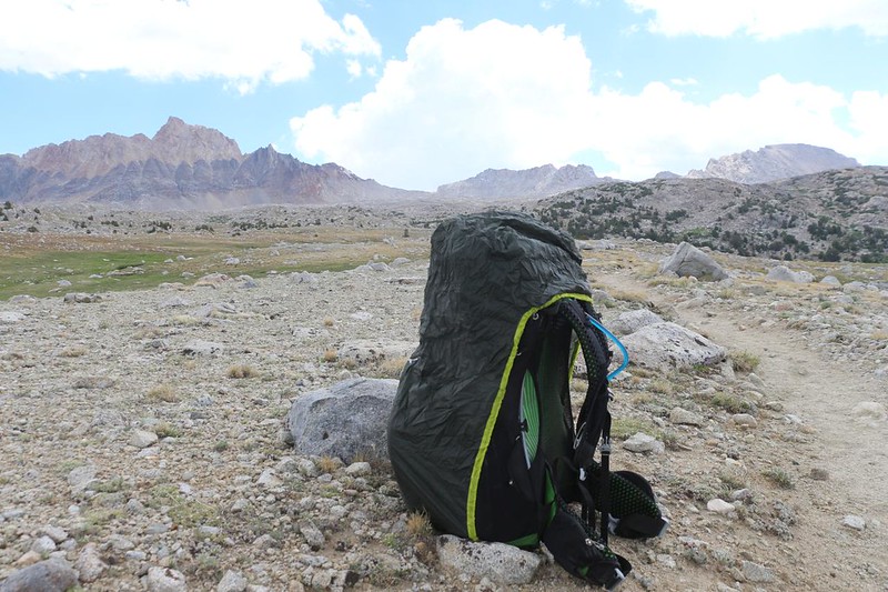
Eventually, it had to happen. A particularly dark cloud drifted overhead, and some rain began sprinkling lightly. I stopped and got out the rainproof cover for my backpack, but it didn’t seem serious enough to warrant donning my own raingear. I was warm enough from the steady ascent that I actually welcomed the cooling effect of the tiny droplets.
GoPro panorama video as it began to rain
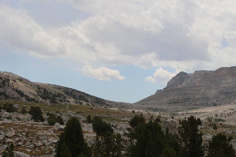
When the trail reached the eastern, upper end of the basin it angled southeast, directly toward Piute Pass. There were some fine views back over the basin, and I decided to stop for lunch on a particularly nice boulder. It was noon, and I’d been hiking for six hours already, so it felt extra-good to take off my shoes and let my sweaty socks air out. I didn’t want to spend too long, however, as the clouds were getting noticeably darker, especially here along the Sierra Crest itself.
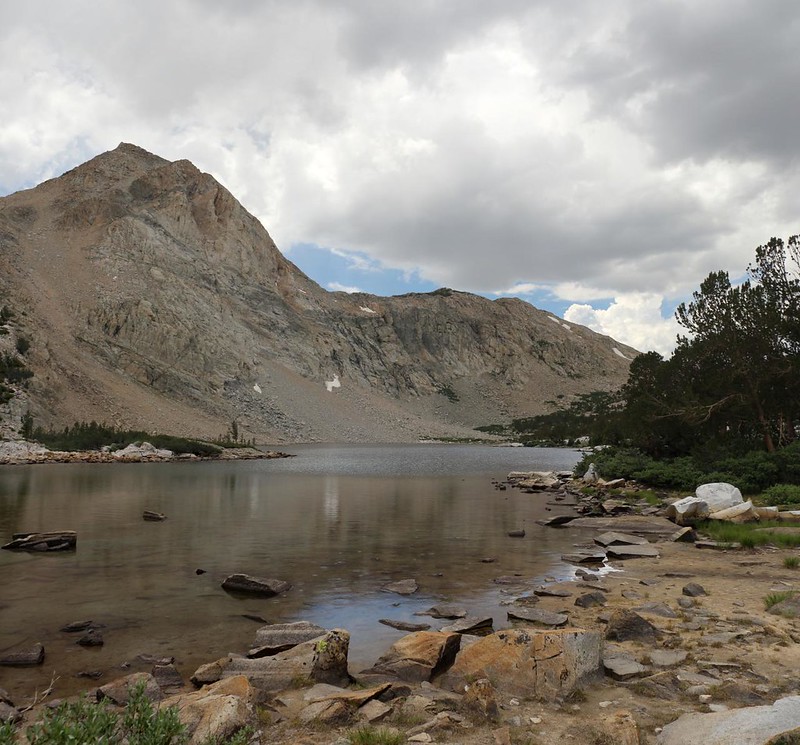
After my break, I continued hiking onward. Only two miles further to go. As I neared Piute Pass, the trail looked down upon Summit Lake, at 11,225 feet elevation. This was the headwaters of Piute Creek.


I climbed up the last grade to the pass, and the skies were looking daunting, to say the least. I decided not to hang around like I normally would, but simply took some photos and videos to mark the occasion. The day’s climbing was over, almost 2500 feet in 9.5 miles. Not bad. And I still felt strong, which was what really mattered.

GoPro panorama video from the top of the pass

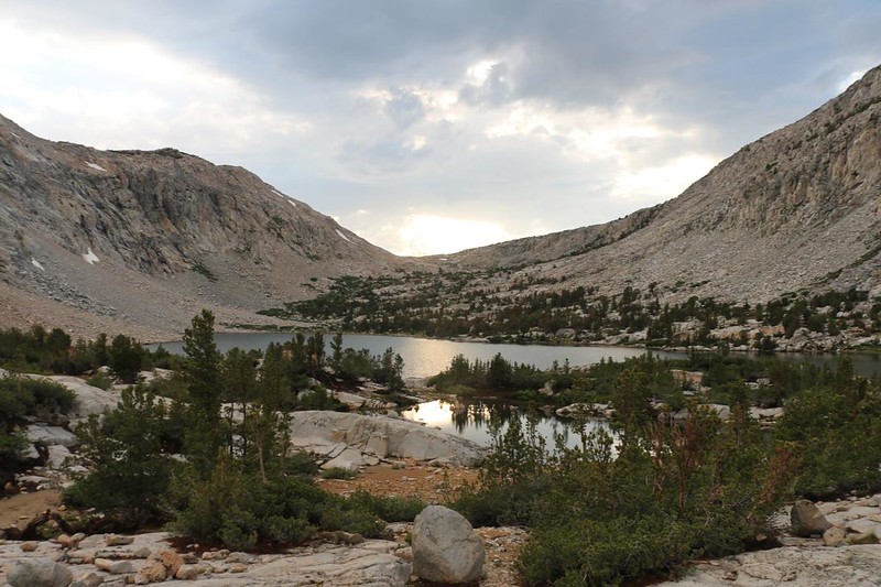
I only had a mile or so left to hike in order to reach Piute Lake, which I’d camped at once before. I also figured that it might be the first water source that I might find on the way down. That was the plan. And the hiking was easy, now that it was all downhill. The sooner I got there the sooner I could get my tent set up, because I could already smell the rain on the air, and I had a feeling that it wouldn’t be long before everything was wet.


I planned to camp at the lower end of the lake, and as I hiked along the shore it began gently sprinkling again. It really wasn’t much, drenching-wise, but it made for pretty drop-circles on the lake’s surface. Just the same, I hiked even faster. The sky was very dark up above me.

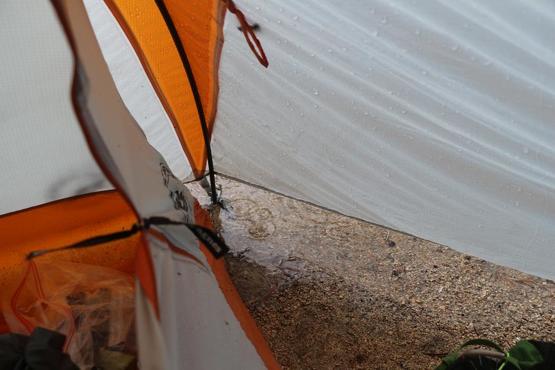
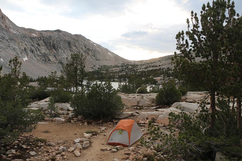
I left the trail and headed into the area east of the lake. There were several flat camping spots in there, most of which looked like they would fill with water in a serious rain. I could tell ones which were flood prone by the circling rings of dirt and wood chips that belied the puddles that had been there before sinking into the sand. Both experience and and the bad luck of others had taught me to pick a gentle slope for the tent, in a location which would drain well and leave my head on the uphill side. You really don’t want your head downhill, and a sideways pitch will keep you working constantly to stay atop your air mattress all night. The sprinkling continued as I set up the tent. I wisely left the pack cover over the top of my wide-open backpack. Then I tossed everything under the vestibule, including myself, and zipped the flaps shut. I listened to the gentle pitter-pat of drops on the nylon, and continued getting everything into place. I laid down a thin foam insulating pad and blew up my air mattress. Then I got inside the tent itself and finally felt safe and secure. I had made it in time!
A few minutes later I heard the first boom of thunder. It was time for the “Daily Afternoon Thunder Showers,” a true staple of hiking in the Sierra in Summer. No trip seems complete without at least one thunderstorm. And this is yet another great reason for waking up early, in the dark: To make it into camp before the rain begins.
I got out my down jacket and put it on. It was getting cold! And that’s when the hail began. Hail always brings down the coldest air from up above. The hail didn’t last long, but the rain sure did. It rained off and on for the next two hours! I had to get out my sleeping bag to keep my legs warm. Then I read my book and waited it out. These storms almost always stop around dinnertime, after the sun loses its warming power, and the clouds receive no more energy.

Video from inside my tent as the afternoon thunder began to boom

GoPro video from inside my tent as the storm began raining and hailing in earnest
When the rain was truly over, I left the tent to see what the place looked like. I had barely had a chance to enjoy the scenery earlier. There were still plenty of clouds flowing north, but there was more blue sky in between them. There was also quite a bit of light to the west, above the pass. Very pretty. I took some photos, then grabbed my water gear and filtered a gallon in the lake’s outflow, which was called the North Fork Bishop Creek. Five days earlier I had entered the wilderness on the South Fork.
Then I decided to take a short walk, just to stretch my legs, which were stiff from sitting so long in the tent. I crossed the creek and visited the Snow Survey Shelter, which was locked, as usual. Staying in remote cabins after skiing into the wilderness to take snow measurements sounded like a pretty cool job. Like getting paid to go backpacking. I could handle something like that.

I came back to camp and set up my stove on a convenient granite ledge. It was a pleasure to cook while standing up. I had some ramen noodles, and it felt good to sip the hot broth on that cool afternoon. I felt it warming my core, and the extra salt I added tasted great after all the sweating I’d done running from mosquitos earlier that morning. I saw a group of people walk by, coming down from the pass, but they didn’t see me. They were all wet and miserable looking. I’m guessing that they didn’t wake up early enough. Maybe they’d learn, but I doubted it. Some folks just love to stay inside their warm sleeping bags on a cold mountain morning, and I fully understand the allure.
Meanwhile, it wasn’t exactly warming up around camp after all that rain. Everything was drenched and soggy. I decided to conserve body heat and went back into the tent. I put on my night clothing and set my alarm. I had less than five miles left to hike before reaching the North Lake backpacker parking lot, and it was all downhill. If I got going early I could make it back to San Diego by tomorrow evening. That was the plan. After five days on the trail I really needed a shower, and my own comfy bed was beckoning. As I snuggled down into my sleeping bag, I thought about the day. It had been a good one. Even the bugs were good in their own horrible way, as they’d certainly forced me to exert myself. Humphreys Basin had been beautiful with all the cumulus clouds. And even the hailstorm had been fun. Life was good again.
For a topographic map of the hike see my CalTopo Page
For LOTS more photos of the trek see my Flickr Page
 << Back to Day 4 Onward to Day 6 >>

