Day 3: Backpacked from Tyndall Creek to Guitar Lake via the John Muir Trail
I woke at dawn to a lovely cool day with clear skies. The weather reports indicated that there might be thunderstorms later in the afternoon, but there was no sign of them now. I chowed down on some pop-tarts and got my gear packed up for what I expected to be a relatively easy day of hiking. Compared to yesterday, that is. I had about 12 miles of hiking to reach Guitar Lake, but there were no major passes to cross, just a stream or two, so I didn’t expect to suffer much at all.
I started hiking and headed down the trail along Tyndall Creek. It didn’t take long before I came across Steph at her campsite. Her tent was still up and she seemed to be in no rush. We spoke for awhile and I told her that I hadn’t heard back from Vicki about ending the hike early using Steph’s Whitney Exit Permit, so the plan was still up in the air. But I told her that I was probably going to do it anyway, unless Vicki said no. Steph then told me that she intended to camp at the small pond just above Guitar Lake, in order to avoid the crowds that would be camping down there. This sounded like a great idea, so I told her that I would meet her later, either on the trail or at the pond, and wished her well on her day’s hike. I was in the mood to crank out some serious miles, not sit around in camp all morning. I think I’ve become a “Morning Person” now that I’m older. I like to wake up early and Get Things Done.
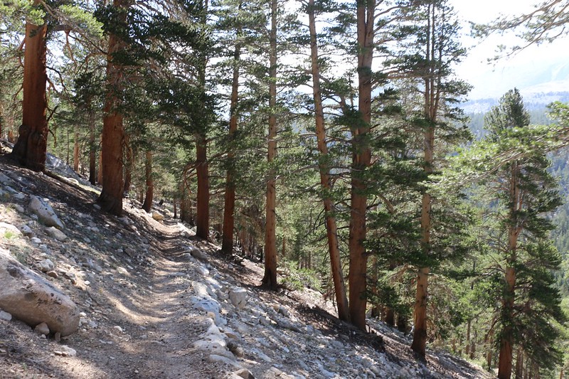
So off I went, climbing gently out of the Tyndall Creek valley, the trail hidden in the shade below the early morning sunlight.


After two miles the trail flattened out as it crested the Bighorn Plateau. Interestingly, there was a large shallow pond up there. A couple of people were filtering water from it, not far from their tent. Interesting place to camp, especially if you liked viewing stars at night, but not a good choice in breezy weather.
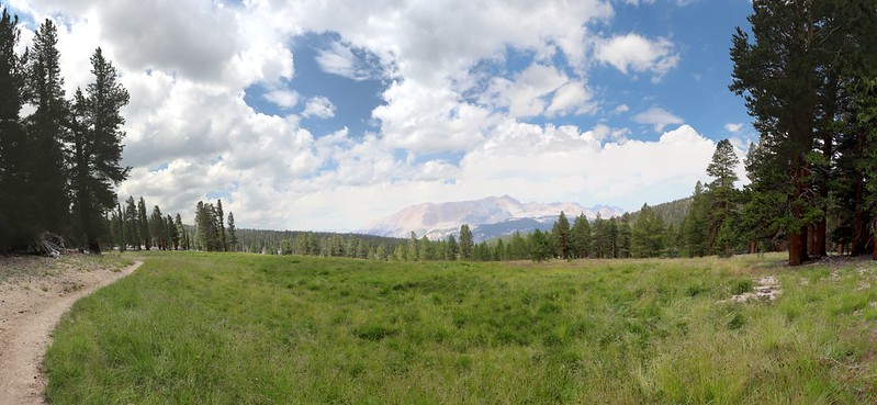
As I continued hiking over the top of the plateau, Forester Pass disappeared behind me, but a new sight arose to the southwest: Mount Whitney! It was my first view of it from west of the Sierra Crest. I took out my phone and fired up my Peakfinder app just to make sure. Yep, that was Whitney all right. My two Korean friends had caught up to me once again, and I pointed it out to them. Now that we could see it, we tried to figure out where the trail would go to get there. It’s amazing how maps rarely seem to convey the terrain as seen from ground level. Ridges that looked small on the map were towering high, with impassable cliffs, from our lowly trailbound perspective. We ended up guessing in the end, hoping that the trail went over the ridge where it was lower and easier.


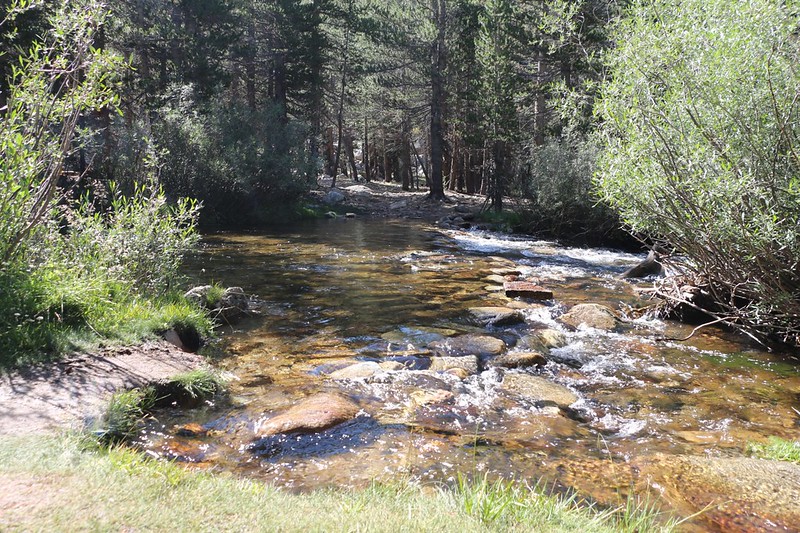
Then the trail began a long, thousand foot drop to Wallace Creek. Along the way the trail entered the shady forest once again, but it also emerged into grassy meadows complete with wildflowers. Part way down I also had to cross Wright Creek, which was cold but refreshing. In order to save weight, I hadn’t brought my plastic sandals this time, as I figured a major trail like the PCT/JMT would surely have sturdy footbridges built across troublesome creeks like this one. How wrong I was! But the bottom was sandy and the cool water felt great, so I let the trailbuilder’s lapse slide this time.


But it was Wallace Creek, down in the deep valley that it had carved for itself over the millennia, which I truly wished had a bridge. It was much larger and flowed faster. It also had a rocky bottom and the crossing was very wide and shallow, so I had to carefully pick my way across, constantly watching my footing and balance, as the uneven rocks and icy water had their way with my poor feet. Many of the rocks were the perfect size to be painful, while others shifted as I placed my weight on them. Naturally, I had a sizable audience the whole way across, which made me even more embarrassed that I hadn’t brought those sandals. Oh well. At least my feet were clean.
Video of me walking across Wallace Creek as I complained about the painful rocks
After that, the trail climbed up and over the western ridge of Mount Young. It was getting hot as it approached noon, and the trees were sparse so there wasn’t much shade. Meanwhile, the cumulus clouds were beginning to form, getting ready to produce the afternoon thundershowers that were typical this time of year in the Sierra. I knew that getting rained (or hailed) on was hit-or-miss with these storms, so I didn’t worry much. Mostly I was glad that they made my photos come out better,
The trail continued down into the Whitney Creek Valley, and as it crossed Sandy Meadow I stopped and had some lunch in the shade of a pine tree along the edge. It was very peaceful. I watched the cumulus clouds growing above me while drifting along toward the northeast. None of them looked particularly dangerous. I checked my GPS and discovered that I’d hiked a bit more than halfway to Guitar Lake. I was feeling good, my belly was full, and the hike was on schedule. It’s hard to ask for anything more.

I headed downhill to the trail junction where the PCT continues southward and the JMT heads east to its terminus at the summit of Mount Whitney. I hung a left and kept on hiking. It was four more miles uphill to Guitar Lake from there. The trail stayed high above Whitney Creek. Down below me was Crabtree Meadow, and off to the southeast was the valley that leads to the Crabtree Lakes. I intended to hike up there someday, but not this trip.
Near the Crabtree Ranger Station, I came across the large plastic container filled with “Wag Bags” which were required gear when hiking over the summit of Mount Whitney. So I took one and stuffed it into my backpack. They were designed to make it easier to carry all human waste out of the Whitney Zone, which was so popular that it had been likened to a giant outhouse, or cesspool, due to the thousands of annual visitors. I read the instructions and hoped that I wouldn’t have to use it. I already knew that there would be no trees up there at that altitude, so if you had to go, you’d most likely be doing it in public. And you couldn’t bury your waste when everything was solid rock, so Wag Bags were the only viable method in the end. The sign also asked that each person only take one bag, as they were dropped off here by helicopter.


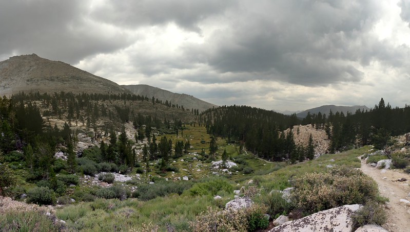
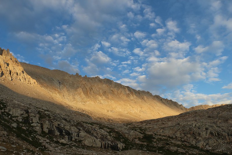
From this point on, the trail was uphill all the way. My legs were a bit tired, but it was only 1pm, so I took my time. I noticed as I hiked that those lovely puffy cumulus clouds had been growing in width, and were beginning to touch one another along the edges. In fact, some of them were getting positively dark underneath. I began to wonder if I was going to be getting soaked soon. I wasn’t too worried about getting cold or hypothermic after being doused, as I had excellent goretex raingear, but I really didn’t want my shoes to get drenched. Soggy feet are never a good thing if the dampness is prolonged. Let’s face it: I was praying that the rain either missed me completely or held off long enough for me to set up my tent and get inside.
Well, my prayers didn’t exactly get answered. As I hiked up the ridge below Timberline Lake I began to feel the drops on the back of my hands, and hear the tip-tap of tiny drops impacting on the brim of my hat. Yes, it was raining, as evidenced by many wet spots on the granite boulders along the trail. I knew that it was advisable to get your raingear on immediately during thunderstorms, as there was only a small window of opportunity between the first small drops and the torrential downpour that could soak a person in seconds. So I hiked over to the nearest pine tree and took off my pack beneath it in the rain shadow of the dense needles above me. I put on my raingear and deployed my waterproof pack cover. I had rendered myself impervious in time. Being prepared and knowing what to do is always satisfying.
I was about to put on my pack and continue hiking when I looked back down at my shoes. I really, really didn’t want to get them wet, as I would be climbing Whitney tomorrow. And then I looked around. It was raining steadily by this time, a gentle rain with small drops, and the dusty trail was dusty no longer. It was completely wet, the same way my shoes would be if I chose to walk out there. Under this tree it was almost perfectly dry. And the tree was leaning in such a way that the trunk formed a solid roof directly above me. I decided to hunker down right where I was and wait out the storm. It would probably drift away soon enough. Now, everyone knows that it isn’t safe to sit under a tree during a thunderstorm, but hiking even higher up a ridge that was soon to be above the treeline made even less sense. Besides, I’d only heard the thunder once or twice while sitting there, and it had sounded far away.
So that’s what I did. I sat on the ground and watched the rain. It was quite peaceful, really. I stayed there for a while, longer than I liked, but it never really rained full blast. A couple of hikers went past me, heading downhill, and they seemed happy to be hiking in the rain. After a while I stood up and looked back down the trail. It turned out that two other guys were also waiting under some trees not far below me. We waved to each other and smiled.


Eventually, the intensity of the rain lessened and the sky began to lighten. I was getting chilled just sitting around doing nothing. I decided to take a chance and start hiking onward, even though it was still raining a tiny bit. My shoes wouldn’t get drenched in these wimpy conditions, I reasoned. So I headed off to Timberline Lake.
I could barely feel the rain with all my gear on, but there were plenty of tiny droplet-rings on the surface of the lake when I arrived. Then the rain intensified one last time and I ducked under a tree and watched. Soon, I saw ripples approaching me from the east, and a strong gust of wind stirred the branches of the trees all around me. I wondered if it was finally going to downpour after all, but luckily this wasn’t the herald of the storm but rather the tailwind. After a minute or two of breeze, the air was calm once more. The rain had stopped completely. And my feet were dry!

Panorama video of Timberline Lake with a breeze that signaled the end of the afternoon rain

It wasn’t until the lake that Mount Whitney had come fully into view up the valley to the east. It was an impressive sight, but it didn’t look anything like the craggy summit I’d seen so may times from Highway 395 on the other side of the crest.
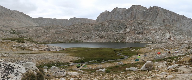
Meanwhile, as the name implies, above Timberline Lake there were no more trees. It was the usual tundra-like High Sierra terrain. Rocks and low grasses and hardy plants. I kept climbing. Soon enough I crested a ridge and there below me was Guitar Lake. It was only 3:30pm but there were already tons of people camped all along the side of the lake. It was a much more popular spot than I had anticipated. The more I looked around, the more people I saw. They were everywhere. And I realized that almost all of them would be climbing Whitney with me tomorrow.

Panorama video of Guitar Lake
It was so crowded that I wasn’t sure whether I would have been able to find a camping spot that hadn’t been claimed already. This made me glad that I’d spoken to Steph earlier that morning, when she mentioned camping at the small pond above Guitar Lake. So I took a few more photos and continued upward on the trail.
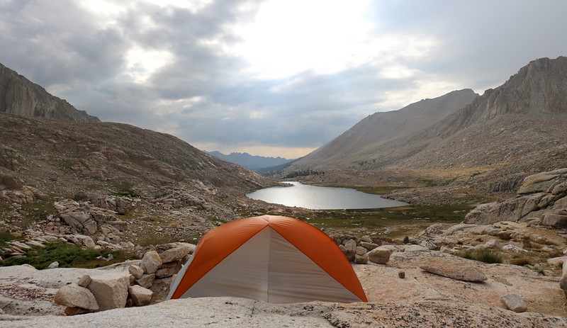
I popped over another low ridge and there below me was the tiny pond. There were already a few people camped there, but it was nowhere near as crowded. In fact, there were two great spots for tents on the northern shore. One spot was sheltered behind a rocky boulder and the other was directly on a shelf made of the granite bedrock. I wasn’t sure whether Steph’s tent was free-standing or not, so I decided to let her have the sheltered spot which had soil in case she needed to stake out her tent. I set up mine directly on the stone shelf, and placed heavy boulders on the tent’s hold-down points.
I had one heck of a great view of Guitar Lake from the door of my tent.
I threw my stuff inside and left my pack at the other spot, to mark it as taken. I blew up my air mattress and spread out my sleeping bag. I got out some food and headed over to the second spot with my book. Then I sat down, reading and eating, and awaited her arrival.
It took her about an hour or so to get there. I waved and she came over, then began setting up camp. She told me that she’d spoken with a ranger down at the Crabtree station and asked him about allowing a different person to use one of the spots on her Whitney Exit Permit. He didn’t exactly say no. He said “Let your conscience be your guide.” He also told her that he would never drink water out of Guitar Lake as far too many people camped along the shore nowadays. We ended up filtering ours from a tiny inlet trickle that fed our pond.
I went and checked my InReach for messages from Vicki. Nothing. It seemed that she must’ve either missed or misunderstood my question about leaving early over Whitney. So I texted her that I was coming out tomorrow anyway, and that I was camping here tonight. That would have to do.
I asked Steph about her “conscience” and she decided that it was OK after all. So we made plans to hike together the next day. The ranger also said that thunderstorms were likely, so we didn’t want to leave too late or we might not be able to summit safely. The top of Whitney seemed like a dangerous place, lightning-wise.
I was excited. My original plan had been to hike to the summit and return to Guitar Lake for a second night. The only downside of the new plan was that I had to lug my heavy gear all the way up the mountain, at least as far as Trail Crest at 13,400 feet. We were currently at 11,600 feet, so we had our work cut out for us.
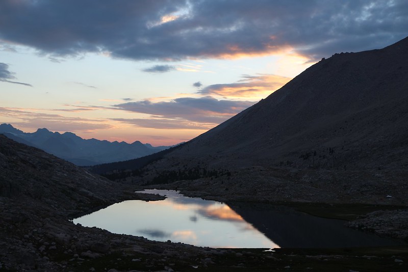
After that, we went back to our tents and busied ourselves with dinner and the usual nightly preparations. I hung out up on the rock taking way too many pictures of the sunset over Guitar Lake and the alpenglow on the cliffs to the east which led to Trail Crest. It was yet another beautiful evening in the High Sierra.
For a topographic map of the hike see my CalTopo Page
For LOTS more photos of the trek see my Flickr Page
 << Back to Day 2 Onward to Day 4 >>
