It was a last minute camping trip. (For us, last minute meant next weekend.) Vicki had just gotten a new backpack and we needed to test it and work out all the bugs before our big summer trip in August. So, on Monday morning I faxed in my permit application for Friday morning and received my second choice trailhead (it really WAS the last minute, for a busy July 4th weekend at any rate), for the South Fork Trail in the San Gorgonio Wilderness, camping two nights at Dry Lake. We decided that we’d try bagging a few of the nearby trailless peaks on Saturday, then hike back out on Sunday.
We arrived at the South Fork Trail parking lot at dawn on July Fourth. There were only two cars there. One belonged to a gentleman who stated that he wanted to watch the fireworks from the summit of San Gorgonio. We warned him of the weather forecast for thunderstorms (a thirty percent chance) and that he might get more fireworks than he’d bargained for! But he didn’t care, and hiked on.

Meanwhile, Vicki fussed with the multitude of settings and straps and adjustments on her new pack. It was an Osprey Viva 50, and was several pounds lighter than her old external frame Kelty. This was one of three parts of this year’s overall plan to improve her uphill speed and abilities. The other two parts were a new North Face “Thunderball” jacket and a pair of Western Mountaineering goose down pants which would replace the heavy fleece she’d been carrying the last few years. These items allowed her to shed several more pounds. As well as several hundred dollars! Ouch! Getting better gear at our level of the backpacking game was costly, indeed.
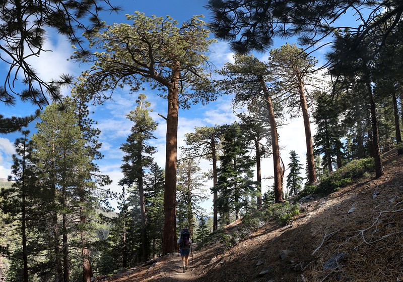
On we hiked, stopping every so often to fiddle with the new pack. We’d been on this trail once before, when hiking the Nine Peak Challenge, so there were no surprises, but we also knew that it would be beautiful. It didn’t disappoint. Tall trees, expansive views, it had it all.

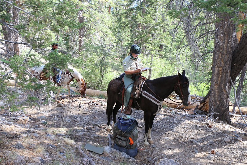
At one point while we were stopped, taking a break along the way, a couple of horses came along. Horses, out here? We’d never seen them in this area. And their riders had uniforms on! Rangers on horseback? What next? Anyway, I went to my pack, got out our wilderness permit, and set it on top, then stepped back from the trail. That’s the polite way to deal with skittish animals on the trail. It turned out that they were volunteers with the SGWA (San Gorgonio Wilderness Association), not real National Forest Rangers, but that was OK. I didn’t care if they looked at my permit. It seemed to make them happy to wield such authority. The only thing I detested were the results of the horses: Their hooves damage the trail and their bodies leave filthy, smelly turds and urine in their wake. I wish that they weren’t allowed in the wilderness, much like the ban on motors and wheeled vehicles. But enough ranting.

Even though it was a drought year, the South Fork of the Santa Ana River was still running. We stopped to filter additional water where the Dry Lake Trail began, not being sure of the little-known “seep” that we’d read about up above us: Maybe it would taste bad. So we filtered and prepared to carry more water than we should have up the next set of switchbacks.

And then the weather arrived. We heard an ominous BOOM of thunder not far enough away, and started looking to get our packs and gear ready. Then a few huge drops began to splat noisily in the dry dust of the trail. I immediately put my new camera into a 4 liter drybag which I had conveniently left hanging on the outside of my pack (for instant deployment). Then I started worrying about myself, and donned my goretex rain pants and jacket. As the frequency of the drops began increasing rapidly, I reached into my backpack and grabbed my waterproof camera, then flipped the top flap back over to prevent water from going straight inside. Everything in there was encased in plastic bags anyway, but that didn’t mean I wanted even more water inside.
I ducked under a huge dead tree whose trunk was leaning out over the trail. It had cracked off about ten feet above the ground, so I was in no danger of being struck by a stray bolt, yet the leaning part offered a wide, rain-free spot to stand. Vicki simply sat down next to her pack in the open. But then it started hailing. This was truly fun! And then it began hailing in earnest, and Vicki sought shelter under another piece of the tree that I was under, that had been sawn off at a sharp angle, leaving a roof that she could sit under.
Video of Hail Falling, as Vicki decides to seek shelter

We sat and watched the rain and hail coming down. Rain! In a drought year! This was great! Let it pour! And pour it did. I took some videos and pictures. We looked for the lightning but never saw a flash. We listened to the thunder and sensed the shape of the mountains and valleys as it echoed and boomed all around us. We smelled the wonderful smell of rain in the forest; it was as if all of the plants had suddenly released their odors into the moist, rain-drenched air. Aaahhh! It was great to be alive!
In some unspoken way, the two of us decided to wait out the rain, expecting it to blast us with water and move on after a relatively short time. Like a child having a temper tantrum, it would soon exhaust itself and take a much-needed nap. This storm, however, didn’t do that. It was tethered to the mountain, you see. San Gorgonio, at 11,500 feet elevation, had created its own gigantic thermal of hot, moist air, which was rising high above it into the colder upper atmosphere. The sun baked southern slopes of the mountain were like an engine powering a gigantic fan, sucking up the heated air of the desert far below. We were north of the peak, and the giant cloud was leaning over us, dumping hail and rain continuously.
We waited and waited, until we grew impatient. We were wearing raingear, weren’t we? Well, what were we scared of? We could see a distant ridgeline above us quite clearly, so it surely couldn’t be raining everywhere! Maybe we were in a non-moving band of rain, and we might be stuck here all day! Now, this is the sort of thinking that is almost always wrong. And it was wrong this time, too. But we didn’t know that. We ran out, grabbed our packs, and dragged them off under some other pines across the river, and proceeded to get everything ready to hike onward. I put on my gaiters and Vicki got out her little pack-covering tarp.

Just as we were saddling up, the two equestrians came back down, covered with their own special horse-riding ponchos. They told us that it was raining all the way to Dry Lake. Oh boy. So much for our theory of being trapped in a small band of intense rain. They rode away and we hiked up the switchbacks on the Dry Lake Trail.
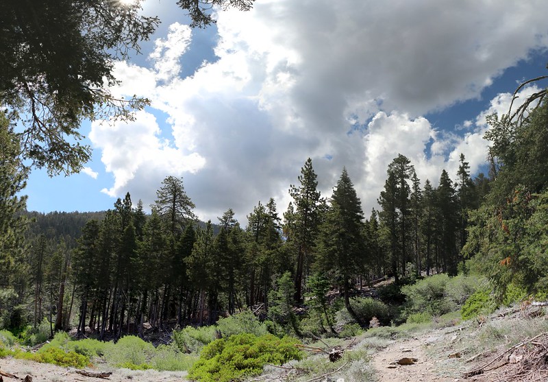
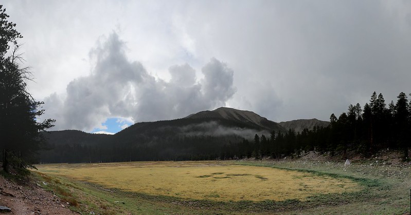
The rain stopped for awhile and I took out my camera for a few shots of some awesome clouds on the peaks across from us: San Gorgonio Mountain, Jepson Peak, and Charlton Peak. The sun came out as thunder continued to boom continuously and ominously from the west. After the switchbacks it got dark and gray once more. I put away the camera as it began to rain, but not the big drops this time; it was more of a continuous gentle rainfall. Soon enough, the trail was running with water. Oddly, the dry streambed didn’t flow at all, only the trail alongside it had become a creek.
We got to Dry Lake and took some more photos of clouds as the rain ended. We hiked into the Dry Lake Campsite and chose a spot out in the open, so that the wet trees wouldn’t drip on us. We set up the tent and got all of our dry items inside it just in case it started raining again. Then the sun came out! It felt great. We began hanging our raingear and packs on various branches and rocks. Soon everything was dry! Well, except for our shoes – there was no hope for them as they were “waterproof” boots and their very waterproof-ness prevented them from drying! Sad but true. Hmmm… Maybe the waterproofing only worked in one direction and both of our pairs were made backwards? Yes, that must be it.

Once dry, we decided to hike back down the trail to the last tiny trickle of water in this area (the seep). We brought spare containers and the filter. We hiked down the slope below the trail until we heard water gurgling, and there was a nice spot to sit on while using the filter. We pumped about six extra liters of water, which should be plenty enough to make it the next two nights. There were storm clouds all around us, and thunder was rumbling the entire time, but we were in a beautiful patch of sunlight throughout this little hike. It was wonderful.

Video of filtering water at “Grassy Spring”

When we got back to camp we took a rest inside the now-warm tent and then the rain began once more. We heard tiny raindrops pattering down on the tent as we lay snug and dry inside. This is definitely one of the best feelings in the world. But the rain didn’t last long, and soon enough we were cooking and eating our dinner. We went back down to the meadow that is Dry Lake at this time of year and took in the last of the day. We wondered about the fellow camping up on the summit, and how he was feeling up there. Most of the clouds had dissipated and it looked to be a fine night for watching fireworks. And then we went to bed ourselves, falling asleep before it was fully dark.
We woke up the next day and I started to get ready. But it turned out that Vicki hadn’t had a good night’s rest. She’d had a cold all the previous day, blowing her nose constantly. She’d brought tons of tissues and was already finished with two thirds of them. She wondered out loud whether she’d have to start re-using the old ones soon. This was more information than I really wanted, but I saw her point. And then we thought about climbing up into those thunder clouds that we already saw developing up on the high peaks. The weather service had an even stronger thunderstorm prediction for today.
And that was when we decided to just hike on out of there. To quit while we were ahead. For after all, our main goal was to test out the new gear, and Vicki seemed to be getting her pack dialed in. Her new warm clothing had also worked perfectly. And so we packed up the tent after breakfast. The inside was still soaking wet from condensation, but we didn’t care. We tried to offer some of our now-extra filtered water to our neighbors but only one of them was awake and they already had plenty. So we picked a likely tree and gave it some extra happiness, helping it to survive the drought.
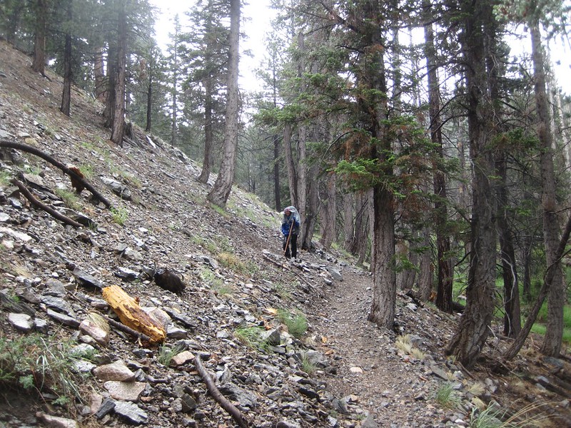
We re-adjusted Vicki’s pack one last time and started down the trail, hoping to beat the rain this time. No more sitting around, hiding under trees, as the rain and hail fell about us. We would RACE the storm! It was a great idea, as the trail wasn’t all that steep. We’d be able to keep a good pace the whole way. But good ideas and reality don’t always meet happily. At least not happily for the ideas.
We hiked along, enjoying the morning. And we made it more than halfway down before we heard the first ominous rumbling of thunder in the distance. That certainly increased our pace, but to no avail. We began to feel the first big drops, and gave up the race. We put on our rain gear and continued hiking, warning other dayhikers heading uphill about yesterday’s hailstorm. But everyone on the trail had some kind of weather gear, so all was well.

Video of Dark clouds and the sound of thunder on the South Fork Trail
A short while later the rain stopped again, and, as we were getting rather warm, we took off the stifling goretex. We paused at Poopout Hill to view the cloud-wreathed summit of San Gorgonio Mountain, but only for a moment. We met more hikers at Horse Meadows, but didn’t stop to talk.


It began lightly sprinkling just as we arrived at the car, so we took off our packs, loaded them into the trunk, and got inside. We started the engine just as the rain began falling in earnest. We had beaten it after all! Perfect timing and a fine end to an enjoyable hiking weekend.
These and other photos can be found on my Flickr Album Page
Interactive Topographic Map of the hike is on my Caltopo Page
