On the second day of our trek we backpacked north on the Pacific Crest Trail from our camp near Windy Pass to Holman Pass, dropping 1700 feet over a distance of eight miles. It was an easy hiking day, with plenty of views along the way.

Since the hike was mostly downhill, we woke up when the sky grew bright, rather than in the dark like we do when there is a big climb ahead of us. Vicki cooked up some breakfast while I packed up the gear inside the tent. An unknown couple had camped next to us the night before, but we never saw them as we were already in bed. They slept in that morning while we quietly got ready. We never did end up seeing them. As we hiked out of camp, I said to their tent, in a soft voice, “Have a good day, neighbors we never met.” And then we were out of there, hiking uphill toward the ridge on the west side of the bowl.


There were fine views north from the ridge, showing Jim Peak and other peaks in the hazy distance. Some of the furthest ones were in Canada. I checked the map while we took a short break, and pointed out our general route. We would drop down to Foggy Pass, cross the Pacific Crest, and make our way to Jim Pass, where we would be back on the east side once again.
We were up at 6700 feet elevation, just below the tree line, and the light green pines nearby were all Larches. Vicki liked them because they have soft needles. Interestingly enough, larches are deciduous conifers, and lose their needles in the fall, after a spectacular burst of yellow color. But it was still high Summer now.


After the two passes, the trail traversed horizontally along the east side of Jim Peak. For a while we hiked through high sloping meadows full of blooming wildflowers. There were even some ripe blueberries! It’s nice to get a free treat on the trail.


We took a break on the northeast ridge of Jim Peak, which the map said was called the Devils Backbone. Regardless of the name, there were some nice campsites up there with excellent views. We took off our boots to cool our feet, and read our books for a while. It was a pleasant spot. Then we continued downhill on the west side, and came to a rushing creek where Vicki took off her shoes yet again, to cool them in the icy water.


We were making good time, and when we came to one of the only campsites on this section of trail we stopped and ate some lunch. Vicki also took her post-lunch nap, while I read my book in peace. After that, the trail began its final descent toward Holman Pass, and we cruised down the easy switchbacks.


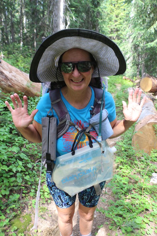
We already knew that there wasn’t any water at Holman Pass, so before we got there, at about the three quarter mile mark, we stopped at a very small creek and filled up our two gallon jugs. At eight pounds each, they weren’t exactly fun to carry, but the alternative of taking a side trip from camp, all the way down to Canyon Creek, was even less appealing.

It was early afternoon when we arrived at Holman Pass. We headed into the campground area, off-trail to the west, expecting to have our choice of campsites, but another couple had arrived first. Oh well, that’s life. We said hello and spoke to them for a while. They didn’t bring any water with them, and had to hike to find it. While they were gone, we set up camp in a nice spot at the far end. We knew that other hikers would arrive later on, and that spot offered a bit more isolation.


Holman Pass was forested, and had no views. But we didn’t really care. Unlike yesterday, at least it had plenty of shade. We hung out inside the fly-free environs of the tent and read our books all afternoon. I may have even fallen asleep! It was a mellow time.

We eventually emerged and ate dinner. Others arrived, most of them thru-hikers coming back from the Canadian border. We congratulated them on a job well done. Hiking 2600 miles in one season is quite the accomplishment! Vicki and I had hiked over 800 miles on it so far, but it took us twelve years! That’s what happens when you have kids, a job, and a mortgage. Oh, to be young and able to take that kind of time off! Now that I was retired, at least I qualified for one out of two! Maybe next year? I was seriously considering it, but I didn’t say anything to Vicki. I knew that she wouldn’t want to try. Oh well. We can all dream, anyway.
When we got back in the tent, we checked out the map. It was all uphill from here to Rock Pass, and Vicki groaned audibly. It was only 1500 feet of climbing, I said, merely a Solid Hiking Day, but she still wasn’t happy. She decided that we should wake up super-early and get a jump on the uphill section, and hike in the cool of the morning. I was OK with that. So I set my alarm and we fell sound asleep.
For a topographic map of the hike see my CalTopo Page
For LOTS more photos of the trek see my Flickr Page
 << Back to Day 1 Onward to Day 3 >>

