On my 35th day on the Pacific Crest Trail in 2023, I made the bold decision to restart my aborted thru-hike, to visit the mountain ranges I skipped due to snow in SoCal, after learning that late-Summer rains had replenished many of the water sources in this normally bone dry region. I decided to hike a series of three week-long backpacking treks, starting with the San Gabriel Mountains. I desperately wanted to complete the Desert Section of the PCT!
From PCT mile 341.9 to 347.2 Total: 5.3 miles 10/15
In my mind, I registered the unusual rainstorms in the way they impacted my home in San Diego, and also while I was hiking in the Sierra, but I didn’t link them to conditions on the PCT. One of them was the violent remnants of Hurricane Hilary, a particularly wet and dangerous storm which set records in four southwestern states in late August. The other was a deep low that bashed California over Labor Day Weekend. Hilary, in particular, severely damaged the PCT along Mission Creek, which I (luckily) had already hiked back in May before stopping my thru hike in Big Bear due to Plantar Fasciitis. At least I wouldn’t have to redo those miles on a destroyed trail.
I’m not sure why, but one day I fired up the Far Out PCT app on my phone and randomly looked at comments along the trail in SoCal. I noticed that there was still water in many locations. Even now, in early October(!), when everything was normally drier than a bone, or literally burning. Water! That’s what I needed. Meanwhile, my feet seemed to be mostly healed. I could do this! I could finish the PCT Desert Section! It was like a Pillar of Fire in my mind. I dug out my old, discarded maps and plans, and, armed with new data from Far Out, renewed my itinerary. I sought Vicki’s advice, and she said that she would help deliver me and my car to various trailheads. Yes! I was totally stoked! The first thing I did was a test hike to Deep Creek Hot Springs (a stop on the PCT) and my feet and gear did just fine. It was going to work, I just knew it. So I started packing food and everything I needed.
I decided to do the three SoCal mountain ranges in reverse order, but still NOrthBOund, because my original thru hike was NOBO. I would do Section D in the San Gabriel Range, then Section C in the San Bernardino Range, then finish it off with Section B in the San Jacinto Range, for mini-treks of seven, six, and five days, respectively, hiking roughly fifteen miles per day. I didn’t dare to try twenty milers, for the sake of my newly healed feet. And there was at least one water source available during each of my planned fifteen mile hiking days, so I would always have water. Water is what hiking in Southern California is all about, after all.
The plan for Section D was simple: Vicki and I would drive our two cars up to the distant trailhead in Acton, leave my car there, then drive together back to I-15 in her car, where she would drop me off at the beginning of Section D. I would hike on, and Vicki would head back home. And that’s exactly what we did. I had to modify my campsite itinerary a bit, as I wouldn’t be hiking fifteen miles that first day due to all the driving time, but it would all work out.


I’m not gonna lie: I was excited to be back on the trail! It was midafternoon, so a bit late, but I had only five miles to hike, so I wasn’t too worried. I purposely delayed our arrival, as the weather was quite hot, above 80 degrees. Not fun for hiking. That’s also why we stopped for a meal in the McDonalds just up the road from the trailhead. Why not relax in air conditioned comfort? Eventually, of course, I had to start the hike. I kissed Vicki good-bye, and away I went, down into the bed of Crowder Creek where it (and the PCT) went underneath the ten-plus lanes of Interstate 15.


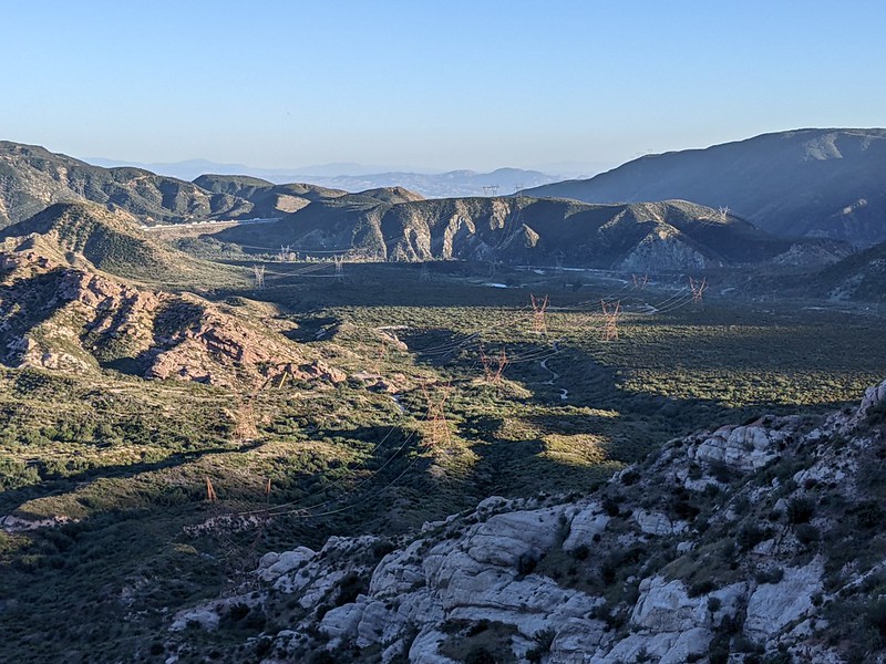
The railroad track bridge was largely clogged with excess sand but there was a good spot for going underneath further south near the creekbed. Then the trail went north again, in typically frustrating PCT-fashion. You’d think I would be used to it by now. I came across actual surface water and mud along a dirt road and had to step carefully to keep my shoes dry. I wasn’t going to start this hike with soggy socks like on my very first day in Campo, back in March. After that, the trail climbed up a bit, but mostly did the work of crossing the wide Cajon Valley. The sound of the freeway slowly faded as I hiked further away.


The biggest feature of the Cajon Valley (and Cajon Pass) is the three sets of railroad tracks. Huge quantities of freight travel to and from the port of Los Angeles through this corridor. There was yet another tunnel under two of the tracks and of course I had to take a video.


After that, it didn’t take long before I heard the first freight train approaching, climbing the big grade out of LA. The thunder of the engines was impressive. They also blasted the horn at the tiny dirt road crossing nearby. More video fun! Cajon Pass is a well-known trainspotting location. Railroad buffs come from all over to watch. Yes, I happen to be a bit of a Train Buff, and I’m not afraid to admit it.


There was a third set of tracks that I had to cross directly, without a tunnel. Always fun, but the trains don’t move too fast on these turns, even downhill, so not dangerous. After that there was a bench on a lookout spot, with great views of the tracks and the valley. I sat down for a moment or two as it was still hot, and the grade was steeper now.


I didn’t realize it, but there were two Deer Hunters just up the trail from me while I was at the bench. They were probably watching me the whole time. It was Sunday on the first weekend of Deer Season (for guns). Luckily, I learned this just before I left. Down below them was a small canyon with a flowing stream. They were waiting for the evening when deer typically come out to forage. Dawn and sunset are the magical deer hours. I stopped to chat with them for a while. Nice guys, hoping to get some venison to bring home. I also got out my $3.99 ultra-cheap orange poncho and wrapped it around the back of my pack. I brought it along just for this reason, as there was zero chance of rain. One of them snapped my photo. I wished them luck, and then it was time to move on.


It took longer than I expected, but eventually I ended up at the top of my day’s climb, hiking along the ridge between Cajon and Swarthout Canyons. The last time I was here with Vicki it was in the Spring of 2019 (a very wet year) and the area was superblooming. Not so in Autumn (even in the wet year of 2023), when SoCal has nothing but brown dried grasses. Just the same, there were more flowers around than you might imagine. By this time of day, the air was cooling and the sun was getting low. The nights were longer this time of year, and I still had some miles left to hike. So on I went.


After a final view down into Cajon Canyon, the trail angled northwest into Swarthout Canyon. New ridge, new views! The sun had already descended behind the high ridge to the west (Blue Ridge which I would be climbing the next morning) and the evening light and color began. I only had a mile or so to go, but it was getting dusky, even if the photos don’t show it. This was the time for Deer Hunting, and I had zero desire to be mistaken for a deer by a hasty hunter who may have had one too many beers on a Sunday afternoon. The orange on my pack wasn’t enough, so I got out my headlamp, turned it on, and aimed it sideways toward the road and the trucks I saw parked nearby. Deer don’t have running lights, I figured.


I made it to the water cache and campsite next to Swarthout Canyon Road and examined the water supply. There were many gallons of water in a protected wooden box. Hooray! I expected it, but I was happy to see the reality for myself. The trail angels keep it maintained all year, as there are also SOBO (SOuthBOund) thru hikers that come here in the fall each season. Thanks!

I didn’t need water yet (but would in the morning) so I looked around for a good tent spot, and I found one. I set down my backpack and got out the tent. By the time I had everything ready, it was fully dark. But that’s OK. I’ve set this tent up so many times I could almost do it blindfolded. I got inside and dressed in my night clothes, a base layer of lightweight Smartwool socks, long johns, and a long sleeve shirt that served to protect my wonderful goose down sleeping bag from the oils of my skin. As a major plus, Smartwool doesn’t suffer from body odor issues, which most PCT thru hikers have too much of after weeks on the trail. Recommended!

I ate my dinner, which was a cold egg McMuffin from the McDonalds we ate at earlier. It tasted just fine. This day was “extra” on my schedule, so this was an easy way to not carry even more food. In fact, I had another one in my possession for tomorrow morning. I went to bed and set my alarm for the wee hours. I had a very big hill to climb tomorrow, and I wanted to be much higher (where the air was cooler) before noon. I texted Vicki that all was well, and then I went to sleep, happy to be back on the trail again.
For a topographic map of the hike see my CalTopo Page
For LOTS more photos of the trek see my Flickr Page
 << Back to Day 34 Onward to Day 36 >>