Day 2: Darling Falls to Tsusiat Falls
This was our first morning on the trail, and the weather was exactly what we expected: Misty and cool. The tarp of the tent was wet on the outside, almost as if it had rained, but it was only the accumulated continuous settling of tiny water droplets from the low coastal clouds. Typical Summer weather on Vancouver Island, in other words, and a good reason not to sleep out under the stars.

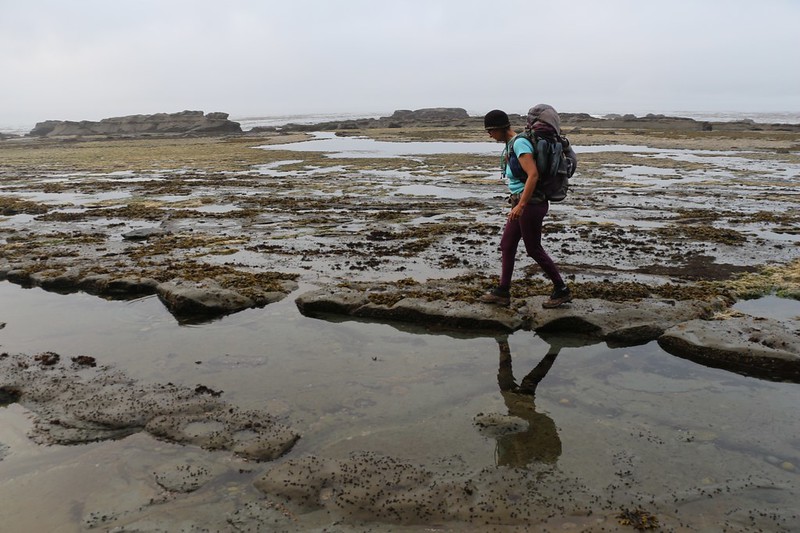
We woke up at first light and started getting ready. Vicki went to the campsite’s bear-proof storage locker and brought back our food while I packed our sleeping gear. Then we ate breakfast while watching the mist drifting by and the waves breaking on the low-tide rocks. We packed up everything else and started hiking right away. We had to hike from here at kilometer 14 to Tsusiat Falls at the 25 km mark. This day would be interesting as it would be broken up into four distinct sections: First along the beach, then into the forest, then back to the beach, and finally into the forest again. In this first section we had the option of hiking on either the beach or the forest, so of course we took the beach route, since the tide was low. As much as we like trees, we really wanted to check out the tidepools and the other marine life. We started hiking before everyone else, so we got to enjoy a magical time together on a deserted beach, creating the first footprints of the new day.


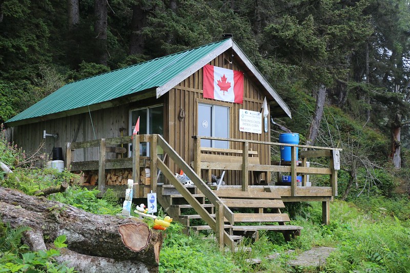
It didn’t take long before we made it to the Guardian Cabin near Tsocowis Creek. Supposedly, the cabin was occupied by a Park Ranger, but there was nobody home on the day that we showed up. The rangers here were all First Nations, and we would have liked to meet them and learn something about the history and culture of the area, but it wasn’t meant to be. We took a break and ate some snack, and imagined what it would be like to live here all Summer. It sounded like a Dream Job to us.

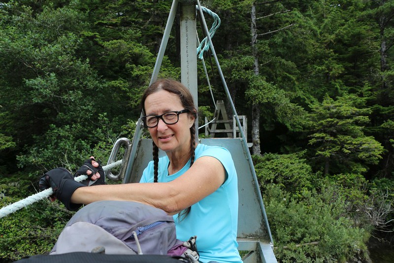
Just ahead, along the shore, were several impassable headlands, where high cliffs met the surf. The only way to keep heading onward was to climb up above the cliffs and hike on the forest trail. Therefore, we got out our gloves and began climbing many sets of tall wooden ladders. Climbing ladders is also what the West Coast Trail is all about. And then we came upon a suspension bridge, which spanned the canyon high above Tsocowis Creek. Nice bridge! It was cool to check out the water-carved creekbed down below. And it wouldn’t be the WCT if we didn’t climb even more ladders. Whew!


GoPro video panorama from the suspension bridge

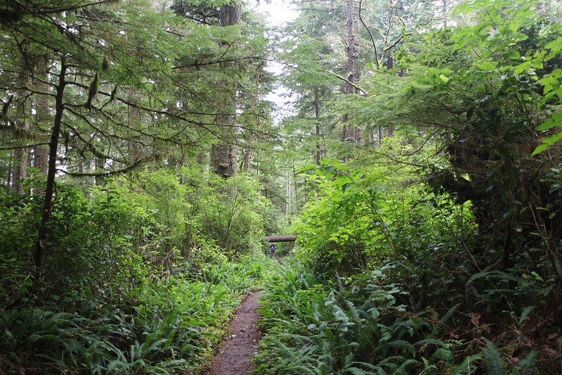
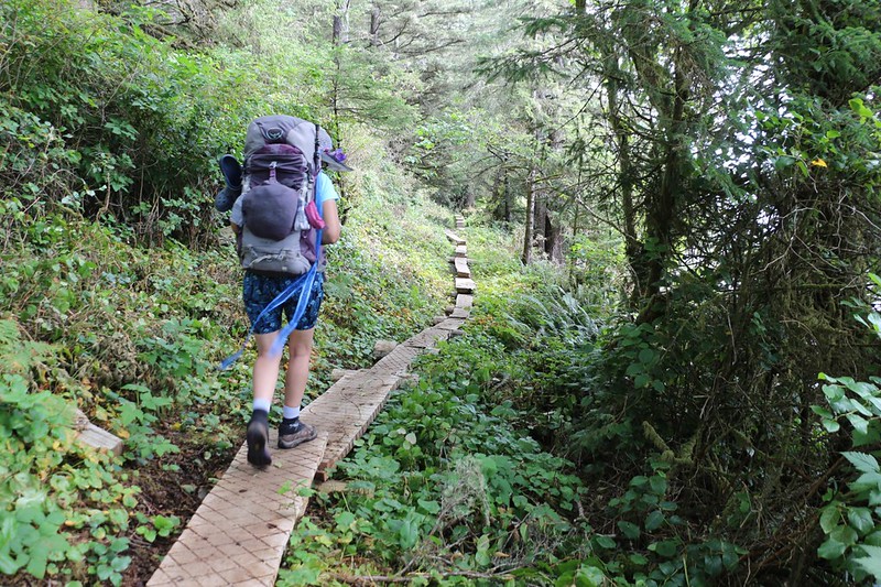
After that, we hiked along on a pretty trail through the temperate rain forest. Pine trees towered above us, and the undergrowth was thick. We decided that it would be brutal to try and bushwhack around here. You’d be lucky if you made a quarter mile per hour. And there were no campsites whatsoever up here in the woods; it seemed that we were expected to camp on the beach every night. But that was OK with us.
GoPro video as we cross another suspension bridge over Billy Goat Creek

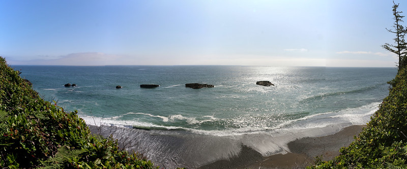
After crossing Billy Goat Creek on yet another suspension bridge, the trail stayed high, paralleling the edge of the cliff that dropped down to the rocky shore. We got occasional views out over the water, and in one spot there were even a pair of wooden chairs! Of course we took a break there. It was too good to pass up.


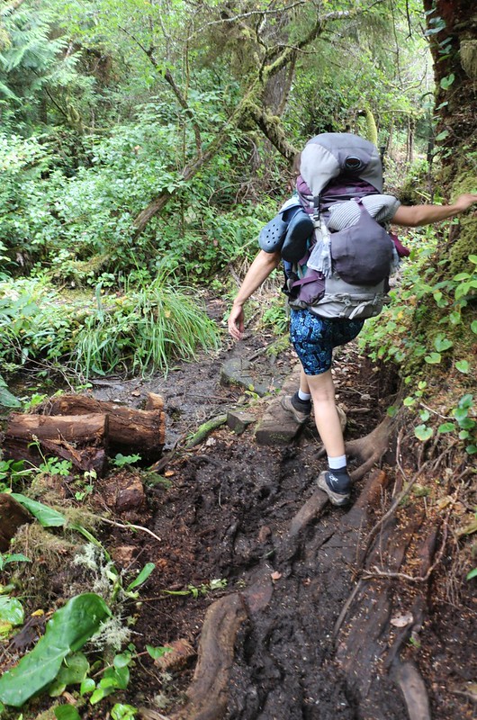
After that, we continued on through the forest. There were plenty of things to check out: Berries and flowers and ferns. An old rusty steam engine. Plenty of crazy wooden walkways in various states of repair. And mud.


At Trestle Creek, the trail descended until it ended at the beach. On this section there was no inland path, and the beach route was only passable at tides below nine feet (which is quite high). We checked the tide tables and the highest tide wouldn’t happen until the middle of the night, so no problem
Hiking along the shore was the part of this trek that I liked the best. I loved the forest and bridges and ladders (not so much the mud) but I’m a biologist at heart and the beach was where the action was. There was all sorts of marine life to check out, and the hiking was fun.


Video of teeny crabs scuttling along the bare rock at low tide

The trail headed back into the forest when we arrived at the Klanawa River. And we knew what was coming: The Cable Car! This was the first of four cable cars on the West Coast Trail, and we were psyched to give it a try, regardless of whether we could wade across the river downstream near the ocean, or not.
Welded aluminum, with sturdy pulleys rolling on a taut steel cable, the cable car was satisfyingly safe to ride in. It seated two, facing one another, and just barely had enough room to fit our backpacks along with our legs in the center. There was a long rope, attached to the car at each end, which looped around two pulleys mounted on the solid wooden platforms at opposite sides of the river. The “free” section of rope went through guides in the cart, at the proper height for us to grab on to it, so that we could pull ourselves across. Much like rowing a boat, where you sit backwards to move forwards, the rope was pulled in the opposite direction to the way you wanted to go. According to the instructions we’d received at trail orientation, we grabbed the rope and pulled the car up to our side of the river. (Gravity tended to keep it at the low point in the center of the river.) Then, Vicki got into the car first while I held it from sliding down the cable. Then she held onto the wooden platform to keep it steady while I loaded the packs, as well as myself. It was a tight fit, and my legs barely made it down there with the backpacks.
We looked around the platform. Did we have everything? Camera ready? GoPro on? Gear secured? We looked at each other. Here goes nothing! And then we let go of the rope and the platform. Now, according to the Blisters and Bliss Trail Guide book, the louder you yell, the further the car will make it across the river. Vicki’s lungs were ready. And away we went! The air rushed by, the pulleys screamed, and the deep water was down below us. I’m sure that it didn’t take very long at all for the car to stop, but it sure was exhilarating.
We sat in the stopped car down at the bottom of the arc and checked out the view. It was quiet and peaceful simply hanging around up there.
But then the hard part began. We had to lift ourselves and our gear, plus the heavy metal cable car, all the way up to the opposite platform. Fun rides in whizzing cable cars don’t happen for free. So we grabbed the rope with our gloved hands and pulled ourselves, hand over hand, yank by yank, grunt by grunt, all the way up the cable. Vicki’s feet were pinned by the packs, so I got out first while she held the rope. Then I lifted out the packs and held it steady while Vicki got out. Success! Then we let go of the car and watched it ride itself back down the low point. We were true West Coast Trail hikers now.


GoPro video of us coasting down in the cable car
Video of us when we let the Cable Car go back to the center

We put on our packs and continued onward. The trail followed the river and gave us some views of the narrow section by the beach. The tide was going out and the water was flowing into the incoming waves, which weren’t quite fast enough to make it inside to the deeper, wider section of river where the cable car was located. It only looked thigh-deep but we were glad that we didn’t risk it. Plus, the cable car had been a lot of fun!
After that, the trail continued onward through the forest. There were solid new walkways in this section, and the hiking was fairly easy. There were also some views over the water as we neared the Tsusiat River, and we stopped for several breaks to enjoy them. It was early afternoon, and we were almost done with the day’s hike. Plenty of time.


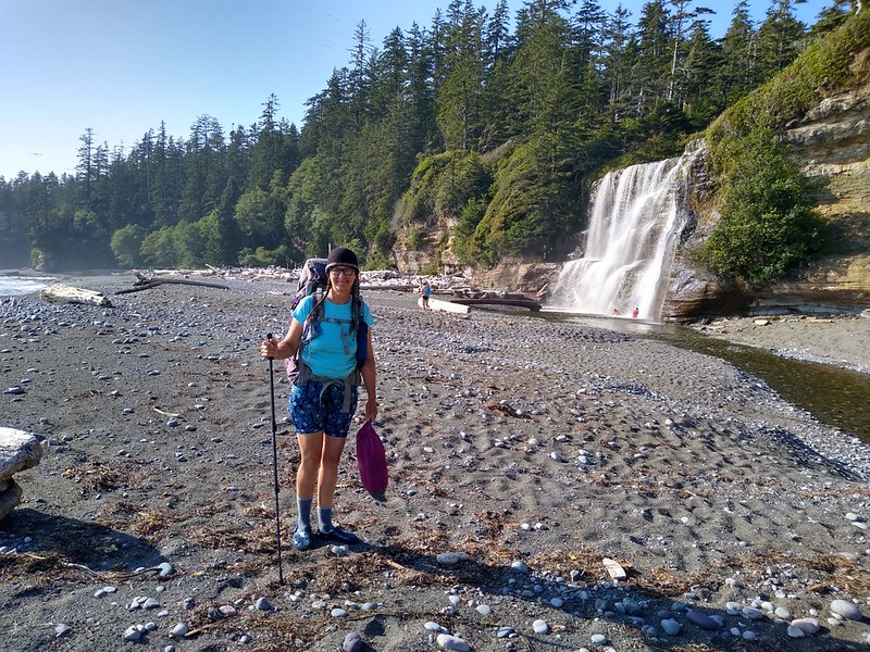
As we neared Tsusiat Falls, we came to one final viewpoint which looked down upon the beach. There were a bunch of people down there, hanging out in the sun! We could hear the falls but we couldn’t see it, although the river itself could be seen making its way to the ocean. We hurried onward. Soon, we came to the sturdy wooden bridge that crossed the creek, and we could see where the waterfall must be. It was like the creek simply ended, and then there was ocean. Let’s face it: Waterfalls are boring from above.
We continued along the trail beyond the bridge until we saw the colorful crab pots and buoy floats hanging from the trees that marked a beach access trail. We headed down the trail and descended a long series of ladders until we arrived at the Tsusiat Falls campsite.


This was one of the more popular campsites on the West Coast Trail, and for good reason. Therefore, it was also one of the most crowded. Even though it was mid afternoon, there were already lots of people there, and, unsurprisingly, they had claimed the best camping spots. But we had our own plan, thanks to another hiker we’d spoken to that morning. He advised us to cross the creek, and camp on the opposite (north) side of the waterfall. There were lots of good spots and you’d be the only ones there. So that’s what we did.
We put on our water shoes and carried our boots across the creek, then headed for the promised land. Along the way we saw plenty of people cavorting in the water by the falls. Several brave young men were even standing under the pounding water. And the falls themselves were amazing. Directly on the beach, they were wide and flowing well, and made a satisfying sound. The mist made rainbows and I took a bunch of photos and videos.


We found a great spot to camp within the driftwood logs. We discovered the signs that a trail crew (trail crews in Pacific Rim National Park are all First Nations members) had camped there. It was truly an awesome spot. Vicki explored a bit into the trees near the cliff and discovered a two-story latrine, and also a bear-proof storage locker! We were truly set now, as we wouldn’t have to wade across the river each time we needed to access our food. Score!
The only thing left to procure was two gallons of filtered water. Now the Blisters and Bliss book recommended that you get your water from above the falls in order to avoid getting sick (too many swimmers in the water below the falls), but most people didn’t want to climb the ladders all over again, and we saw them filling their bottles from the creek. We decided to get our water part way up the falls. So Vicki donned her rain jacket and her water shoes. She walked around behind the falls and filled our “To Be Filtered” water bag directly from the downpour. She did this four times in total, until we had our two gallons. Good job, Vicki! Yes, I admit that I was too much of a wimp to go back there.

Video of Tsusiat Falls

Video of Vicki standing under the waterfall collecting water
After that, it was time to eat some dinner and watch the sunset over the ocean. What a picturesque place we were camping in! We took an after-dinner stroll and surveyed our domain (on this side of the creek). We walked a bit further and found a nice cove with a small sea cave. Then we came back and checked out the bright orange campfires on the other side of the falls. They looked like fun, but we’ve been camping so long in the bone-dry forests of California that we got used to having no campfires at all. So we headed into the tent, and read about the next day’s section of trail. This became a nightly ritual. Between the map and the book and the tide-table, we had a pretty good idea of what the following day would be like. We knew it would be fun, but what kind of fun? That was the question.


For a topographic map of the hike see my CalTopo Page
For LOTS more photos of the trek see my Flickr Page
 << Back to Day 1 Onward to Day 3 >>
