We spent a fun day at Devils Postpile National Monument, checking out Rainbow Falls and the Postpile itself, while I also hiked several miles on the John Muir Trail as it passed through the area.

We woke up to the faint smell of smoke, and noticed the hazy air. It seemed that the wind had shifted once again, bringing the smoke down here from the large wildfires up north. There were no fires near us, nor any danger but the smoke was everywhere. 2021 had been a very bad year for wildfires in California. But we weren’t going to let it ruin our day, so we packed a daypack full of snacks and lunch and water, and drove south to the Reds Meadow Resort. We arrived just in time for the grill to open. I ate an egg-filled breakfast burrito, and Vicki had a stack of pancakes. That’s a good way to get your day going!
Then we drove down to the Rainbow Falls Trail parking lot. I put on the daypack, and we headed down the broad, easy trail to the falls. This was a major tourist route, and nothing like the narrow trails we usually hike. This was a hiking superhighway.


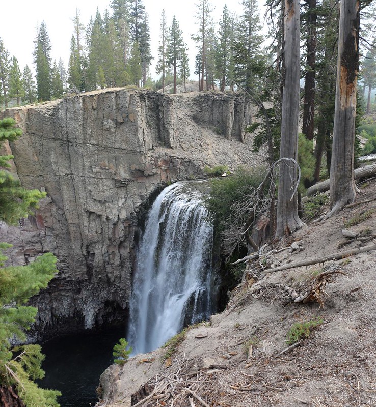
It was late-season in a dry year, so the falls weren’t exactly booming, but it still looked like a proper waterfall. There were several rail-lined viewing spots that were perfect for taking photos and videos. I took too many, of course. It turns out that the best time for viewing rainbows at Rainbow Falls is later on in the day. We showed up in the morning and the sun was too low in the east. Live and learn. We saw a bunch of people below us, playing in the riverbed. They had taken the longer trail to get there. This trail went down (which implied coming back UP) and Vicki decided that she didn’t want any part of it. Her lungs weren’t happy in the smoky air, and we didn’t want to push them. So we simply enjoyed the falls from off to the side, which was fine.


After that, it was time for Phase Two of our plan. I was going to hike the JMT-PCT north to the far end of Devils Postpile National Monument, to the spot we visited yesterday, where the two trails diverged. This was part of my goal of hiking the entire JMT, in which I only had a few sections left to cover. Meanwhile, Vicki planned to visit Sotcher Lake, and eventually meet me up by the Postpile itself. Phase Three would be the two of us seeing the monument’s main attraction.
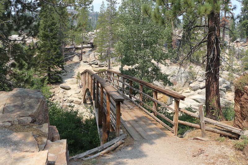
The JMT crossed the Rainbow Falls Trail and that’s where we parted ways. I headed downhill and soon crossed the river on a lovely wooden footbridge. After that, the trail climbed upward on the western side of the river valley before heading north, parallel to the Postpile.


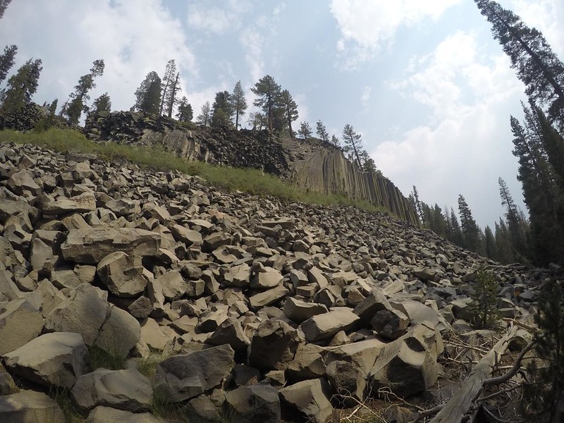
Unfortunately, the smoky haze made my view of the Devils Postpile less exciting than it could have been. Also, much like the falls, it was still in shadow. But that didn’t stop me from taking photos. The advantage of being up there on the JMT was that I saw it from a perspective rarely seen by the typical tourist.


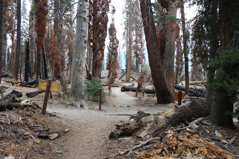
I hurried onward, and pretty soon I arrived at the trail junction where the fire had recently burned. Success! Another section was complete. I turned back toward the Postpile and crossed the river on a sturdy metal footbridge, then headed for the parking lot by the Ranger Station. Sadly, I lost cell phone signal right there, so I couldn’t text Vicki. I hiked back over the bridge until Mammoth Mountain came into view and the text went out. It turned out that Vicki had no signal either! But I didn’t know that. So I sat around and waited. Luckily, I had my book to read. Eventually she showed up, of course. She had gone swimming in the lake, and was quite happy about it.


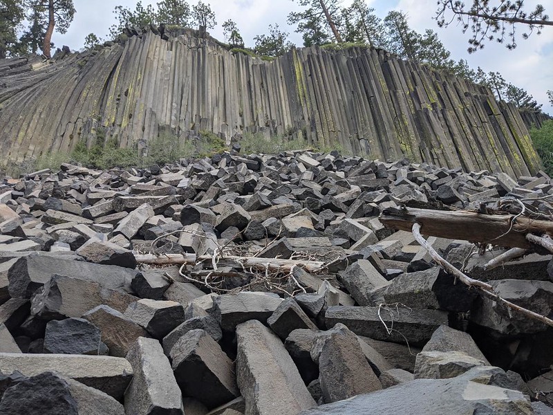
The two of us hiked together to check out the Devils Postpile. And it was quite impressive! I had seen plenty of photos, but the reality was quite another thing altogether. Especially after reading the interpretive signs about how it was formed. Basalt columns often form when a pool of lava cools, but they rarely get exposed to view. These columns formed twenty million years earlier, and it wasn’t until the recent ice age (twenty thousand years ago) that glaciers carved out the valley and left the Postpile behind when they finally melted. Pretty cool, we thought. And it was interesting how the columns weren’t all perfectly vertical. A number of them were canted at crazy angles, which had nothing to do with glaciers. They were formed that way. Down below the vertical columns was a huge pile of broken pieces left over from erosion and the glacier.


We met up with several other visitors, and we helped each other take group photos. I noticed, thanks to the pile of broken stone at the bottom, that the columns were not always hexagonal. Some had seven sides, and others had four or five. When you think about it, there was really no reason that they had to be six-sided (they aren’t crystals, after all), except that six is a stable shape. Particularly when packing what were originally round cylinders as tightly as possible, crammed in next to each other, while they were still hot and malleable. Interesting. I’m sure that a geologist could come up with a better hypothesis than this one, but I like my idea anyway.


We continued south beyond the Postpile, so that we could take the loop trail to the top of the pile. Vicki wasn’t excited about climbing, but at least it was cloudy and not so miserably hot. And we were immediately rewarded for walking that far. In front of us was a cliffside made entirely of basalt columns sticking sideways out of the hillside! They were really cool looking. These seemed smaller in diameter than the vertical ones in the main Postpile, but I still liked them anyway. And then we continued up the trail to the top. It wasn’t all that far, about 200 feet of climbing, and we ended up extremely glad that we did it. You should do it, too!

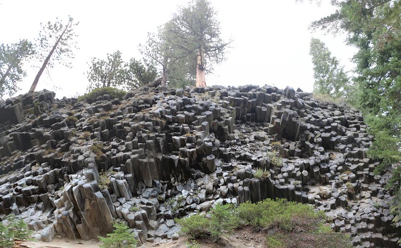
Being on top of the Postpile really gave you a feel for how it was exposed back in the Ice Age. The tops of the vertical columns had all been worn smooth by the passage of the glacial ice, as if a mighty giant had used a huge piece of sandpaper to wear down the raw edges of the basalt until it was smooth, like polished end-grain on a wooden board. Very cool.
There were also lots of signs and bright yellow strips of caution tape warning people not to walk down to the top edge of the main Postpile, which became a vertical cliff, and of course there were plenty of steep, sandy paths indicating that tourists had been doing it anyway. Vicki and I, preferring to stay alive and uncrippled, kept our distance. I have to admit that I might have tried it myself, back in my indestructible twenties, but not now. Perhaps the proliferation of cell phones and selfie-obsessed social influencers has made things worse than ever before. I would have asked a Ranger, but they were all in hiding out at home due to Covid. Oh well. Maybe someday I’ll find out.


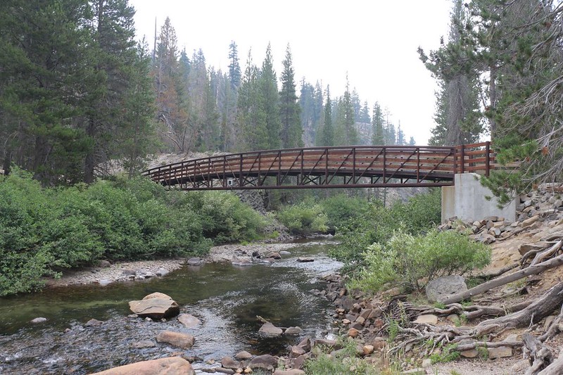
After that, the trail headed down to the bottom, back near the beginning of the main Postpile trail. We headed toward the car, and along the way I showed Vicki the cool metal footbridge over the river. It had a great view over the meadow and river to the north.

After that, it was dinner time! We decided to try something other than burgers, so we drove up the steep grade out of the park, then down into the town of Mammoth Lakes. This was a great tourist town, whether you were skiing in the Winter or biking and hiking in the Summer. Plenty of motels and campgrounds and restaurants everywhere. Vicki chose to get some seafood at a ramen place, and I opted for some pizza. This town had it all. The afternoon brought changes in the weather and it was sprinkling a bit. So we ate in the car, as Covid was happening and there was no indoor dining going on.
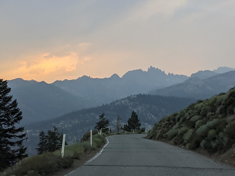
After that, we headed back up and over the hill into the National Monument, and our campsite reservation let us get in with our car. We also used our lifetime senior parks pass, so the entry was free, as well. This was one of the rare occasions when it’s good to be old. We stopped at the Minaret Vista viewpoint and checked out the hazy skyline as the sun set in the west. Very pretty. Then we drove down into the valley, to our campsite, where we spent the night in the back of the Rav.


Our original plan had been to start yet another four day hike just south of here, leaving out of Duck Pass in Mammoth Lakes. We were planning to bag yet another section of the John Muir Trail. But when we woke up the next morning, the smoke was even worse than yesterday. Vicki was not amused. And her lungs were even less amused. We talked it over, and decided to abort the next hike. Maybe next year the air quality would be better.

So we packed up the car and headed on home to San Diego. It was a six hour drive, but that was OK. We talked about the trip, and about how all of our gear had worked perfectly. The only real downsides we experienced were the heat at low elevation, and the smoky haze. The lakes and views and waterfalls and Postpiles had been super-excellent, and we were both really happy that we’d come up here. I’ve been hiking in the Sierra Nevada for a number of years, but this was the first time I’d been in the Mammoth area. It was really beautiful around here, and I felt certain that I’d be back soon enough.
For a topographic map of the hike see my CalTopo Page
For LOTS more photos of the trek see my Flickr Page
 << Back to Day 4

