I backpacked on the Fuller Ridge Trail and camped in Little Round Valley, tested out my new tent, and climbed San Jacinto Peak the following morning before heading back to my car.
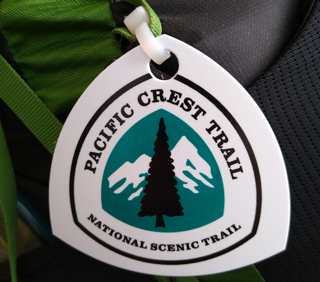
Of course, the trip had more than one purpose. I could have tested my tent in the back yard. The most important part wasn’t even the backpacking trip! More precisely, it was about the next backpacking trip. Vicki and I both got Pacific Crest Trail Long Distance Permits to hike 500+ miles through the state of Washington, and I wanted to get official PCT Hangtags to display on our backpacks. I like them, and we’ve seen plenty of them in the Sierra over the years. Unfortunately, there were very few places which would issue them. Two days earlier, I drove all the way to Campo, at the PCT Southern Terminus, and discovered that the PCT Employees whose task was to distribute the tags had already headed north to follow the “bubble” and didn’t even bother to service the last of the May hikers! Sad but true. But there were other places to get a tag, and all were several hours away from San Diego. One of them was the Idyllwild ranger station for Mount San Jacinto State Park. I drove there, showed the nice lady our permits, and she gave me the hangtags. Mission accomplished! But as long as I was driving over two hours each way, I thought that an overnight hike was a good idea. That same nice lady issued me a camping permit for Little Round Valley, and I was set.
With that chore out of the way, it was time to visit my old friend, the Fuller Ridge Trail. It was also part of the PCT, so it was perfect! It took me an hour to drive up the long winding road to the trailhead, but it was worth it as the trail was beautiful. I got out my backpack and made sure that everything was ready.


According to my Caltopo app, I only had about six or seven miles to hike, so it was OK that I was starting this late in the morning. Also, I only had one night of food in the pack, and that made it light enough to hike faster than I would in the High Sierra. True, I had about 2500 feet to climb, but that just seemed like a normal day to me. I was probably lying to myself, but that’s also normal. We all think we’re tough in the beginning of a hike.
So I put on my backpack and started walking. The first part of the trail ascended very gradually, and looked to the north toward mighty San Gorgonio Mountain. At 11,500 feet, it was the highest peak in Southern California. There was even a bit of residual snow on it, which made me glad I wasn’t over there.


After a mile or so, I crossed into the State Park section of the Fuller Ridge Trail. This part sidehilled along a northeast-facing slope, and there were many big pines. Then it switchbacked upwards near Castle Rocks and eventually popped out on top of the ridge itself. This was my favorite section of the trail. There were great views of San Jacinto Peak to the south, Coachella Valley and the windmills to the east, and the distant views of Riverside to the west, depending upon which side of the ridge the trail was on. It hopped from one side to the other more than once. Fun!


The ridge itself kept on climbing, right up toward Folly Peak and San Jacinto Peak, but the trail did not. It sidehilled along on the western side, gradually climbing as it went. A few years back the new CCC (California Conservation Corp) rebuilt parts of this trail. New granite steps were always enjoyable.


Once the PCT intersected the Deer Springs Trail (which began far down the hill in Idyllwild), the PCT turned right and I turned left. My plan was to head toward the summit. Along the way was the high campground known as Little Round Valley, where I intended to stop. Tomorrow morning would be a better time to climb the rest of the way to the top.


I really discovered what a hot May day it was! After climbing in the sun through low thorny scrub, I took a break in the shade of a tree for a while, then continued onward once I cooled off. This is when the trail really started getting steep, so my pace slowed down a bit. I was in no rush, after all. What was I going to do if I got into camp early? Not much. Read a book, maybe. So on I trudged, taking baby steps up the trail in the sun.


I arrived in the campground with plenty of afternoon to spare. I claimed my favorite campsite up on the hill and took my time setting up my new tent. It was the same model as my old one, the 2016 version, but the zippers were failing on the old one. I really loved that tent, the Copper Spur UL1, so it was interesting to see the new features, and whether they cheaped out on anything. Only time will tell on the materials, but it seemed just fine to me, and I liked the new gear loft for drying out my stinky sweaty socks. There’s money well spent!
After that, I walked down to the meadow and filtered enough water to get me up to the summit and back to my car tomorrow morning. Then I ate some ramen noodles for dinner and read my book as the sun went down and the air cooled. It felt good to be back here in Little Round Valley.


As always, I woke up well before dawn. I can only sleep so long. I ate my usual oatmeal breakfast and instant breakfast drink, then packed up most of the heavy gear. I left that stuff in the tent, and only took some water in my backpack. Slackpacking, they call it, when you aren’t carrying much weight, like being a temporary dayhiker. I headed out across the valley and began climbing the mile or so of switchbacks up toward the summit. It was cool out, and I was able to hike fast without raising much of a sweat. Good hiking weather.


I met the trail that leads down the other side of the mountain to the Palm Springs Tramway, but of course I didn’t take it. There was another campground down there, called Round Valley (as opposed to Little Round Valley on this side). It was possible that I might meet up with another early-bird hiker from that campground, but it didn’t happen. Instead, I met up with a PCT Thru-Hiker up at the Summit Hut! He spent the night in one of the bunks, just for the heck of it, I guess, even though he knew he wasn’t supposed to. Technically, it’s for emergencies only. But I didn’t care, and he certainly didn’t hurt anything. Heck, he carried all his own water up that last mile of trail!


He said he saw the sunset last night, so he was done with the peak. But not me. I began the off-trail rock scramble up to the summit. I’ve done it many times in the past, and the big granite boulders are fun to climb. At 10,834 feet elevation, San Jacinto Peak is one of the “Big Three” or “Three Saints” of SoCal: San Jacinto, San Gorgonio, and San Antonio. You could see the other two from up there, if you knew where to look.


After enjoying the summit for a few minutes, I decided that the air was too cold, when added to the steady breeze, and that my sweat was drying too fast. Time to get the heck out of there, and build up a new, fresh sweat! I started hiking in earnest this time. It was all downhill, after all. My kind of hiking, just striding along, letting my legs stretch out. No baby steps for me!


I climbed the small hill to my campsite, and began putting away the new tent. I stuffed all the heavy gear back into my pack, slung it over my shoulders, and tightened the hip belt. It was time to get going! Seven miles of downhill cruising awaited me. And away I went.


Naturally, by the time I got back to the Fuller Ridge Trail intersection, I was feeling a hot spot developing on one of my feet. Right below the toes, on the ball of the foot. This is where I often get blisters, usually after an extended downhill hike. In other words, I should have expected this, and acted accordingly. Maybe baby steps would have been a better idea. But no. Maybe some pre-emptive taping would have been best. But it was too late for that. Fixing your feet should always be done instantly on the trail, because they don’t fix themselves. So I got out the Leukotape and applied my usual repair. It works. I was just lazy, and now I had a small blister to show for it. Would I learn? I doubt it.
Then it was time to make some mileage on the trail, but maybe a bit slower this round. It was a lovely morning, and the views were superb, as always. This trail really is a joy, whether uphill or downhill. I had a few hours of hiking ahead of me, so I got down to business.


I got to the car and tossed my pack into the back. It was time to head on home. Luckily, it was a Saturday, and there was little likelihood of nasty LA traffic. I took my time driving down the long dirt road to the highway, then cruised on local roads to the I-15 Freeway. After that, it was smooth sailing, and I was home in a couple of hours.

Safe in the glovebox were the precious PCT hangtags that I drove all the way to Idyllwild for. The fun hike to the summit of San Jacinto Peak was an added bonus. And my new tent worked great! It was time to start getting serious about a fun Summer full of backpacking. Just the way I like it.
For a topographic map of the hike see my CalTopo Page
For LOTS more photos of the trek see my Flickr Page

