I did a solo section hike on the Pacific Crest Trail starting at Soledad Mountain Road near the Golden Spike, heading north, passing through picturesque Vasquez Rocks County Park, and ending in the town of Agua Dulce. This hike was interesting in that I used an eBike to deliver myself to the beginning trailhead, and picked it up afterwards using the car, which saved me a long road walk.
The night before the hike, I stealth-camped inside the back of my car in the trailhead parking lot on Soledad Canyon Road. It was fairly quiet, but a couple of folks stopped by during the night to party in their cars. Luckily, they never bothered me. I woke up well before dawn and got my gear together, then drove on up to the town of Agua Dulce (the name means Sweet Water in Spanish). The day before, I had eaten lunch at the Big Mouth Pizza, and the owners said it was OK to park there, if I used the far end of the lot. Thanks!
I got my eBike off the rack and took out two headlamps. My new bright Nitecore was aiming forward, and my older one was set on “Red Mode” and was aiming backwards. It was cold that morning, in the mid-thirties, and I was wearing my gloves, wool hat, and windbreaker jacket. It was dark as I headed south out of town, and rush hour was just beginning. Lots of people commute to L.A. from way out here, and they also like to leave early. I was glad for the red light as more and more cars passed me on the winding downhill road toward the freeway. Once I turned left onto Soledad Canyon Road all the traffic was oncoming, so it was much safer. This final stretch was uphill, and I was happy for the electric assist! It really made all the difference. Highly recommended.


After locking up the bike just out of sight near the lot where I spent the night, I put on my pack and started the day’s hike. It was ten miles or so, with two ridges to climb along the way. It was supposed to be fairly warm that day, in the upper seventies, so I was happy to get the initial climb started early while it was still cool. There would be plenty of time later on to hike uphill in the sun.
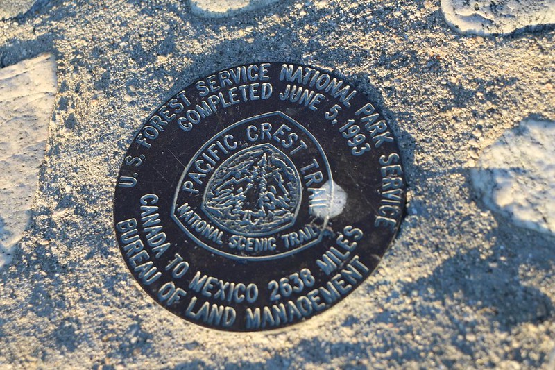
The first step was to cross the Santa Clara River, which really wasn’t flowing much at all, even this early in the dry year of 2022. I hopped across near some stagnant puddles and walked on over to the railroad tracks. We had been here back in 2021, in order to visit the Golden Spike, a monument commemorating the official completion of the Pacific Crest Trail back in 1993. I took a couple of photos and continued north on the trail, via a small canyon.


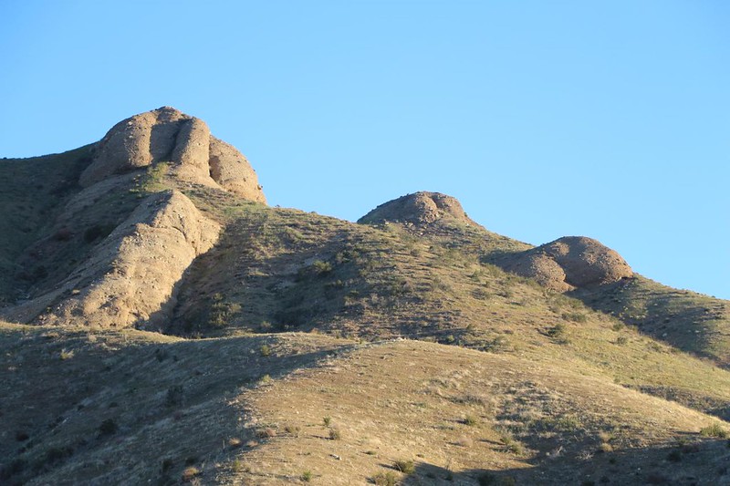
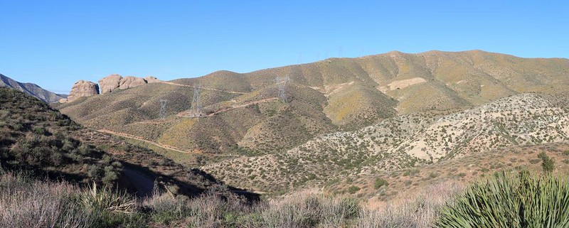
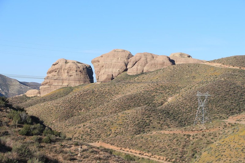
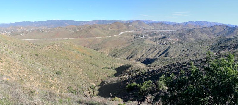
The initial climb was about 750 feet in a mile and a half, so it was a mellow grade. I noticed on my map that Three Sisters Rock was somewhere to the west, but I never actually saw it along this stretch. Instead, I gained better views of Soledad Canyon. Off in the distance I could make out Mount Gleason, where Vicki and I had hiked the PCT last year. That was a very dry section of trail, and I was glad that it was finished.

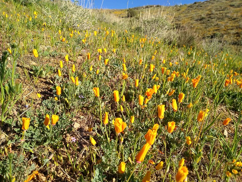
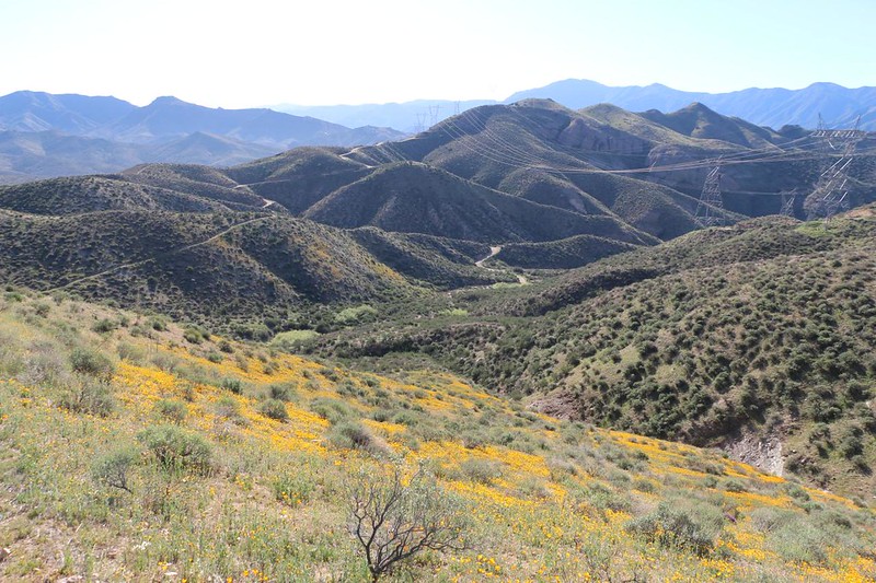
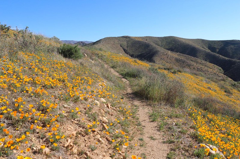
As I gained elevation, the land around me suddenly abounded with poppies! They were on every south-facing slope. As the sun rose higher and the air grew warmer, the flowers opened wider. They were quite stunning, and I stopped for too many photos, as usual.

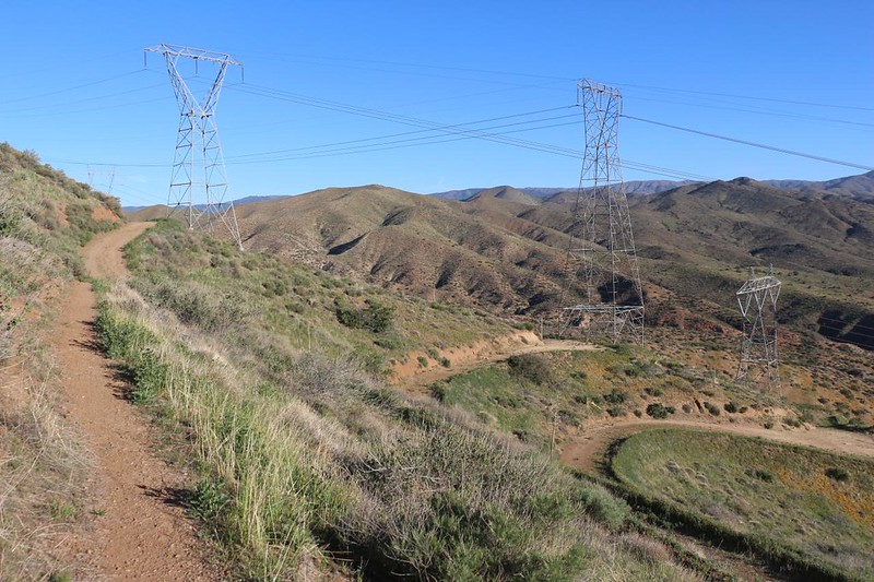
I crossed the ridge into upper Bobcat Canyon, and the trail descended a bit as it made its way around the upper perimeter. This was when Three Sisters Rock finally came into view. There were a couple of high voltage powerlines running across the ridge, and some dirt roads to service them, but the PCT remained a proper trail, which I liked. You never know what will happen on a dirt road.
As I continued up the far side of Bobcat Canyon, the poppies were once again out in force. After the dry Winter of 2022, it was wonderful to experience such an excellent bloom. Thus far, the poppies had completely made my day.


Soon enough, I made it to the high point of the day’s hike. I came over a ridge, and down below me to the north were the winding concrete strips of Highway 14. Even though it was far away, I could hear the sound of big truck engines laboring up the long grade out of Palmdale. But that only lasted a short while, as the PCT immediately plunged into a narrow canyon with limited visibility. It was quiet down in there, but I have to admit that I liked the views from the ridge much better.

The downhill didn’t stop until I had lost most of the elevation I’d gained that morning! Oh well, I said to myself. Such is life on the PCT. By then I was well below the grade of the freeway. I could see the tops of trucks as they went by up above me, but not the cars. There was plenty of sound, however. Up ahead was the Hwy 14 undercrossing that I saw on the map. As I approached, I realized that the tunnel under the freeway must be quite long, as the road was so high up above the canyon floor. Eventually, I saw the iron girders set around the opening of the concrete culvert. They were placed there to prevent large trees from clogging the passage during flash flood events, much like a huge strainer. I approached the tunnel and entered. It was dark and cool inside. A small stream of water flowed down the center of the arched tube. It was strange that the water flowed “up” the canyon in this place, but it may have been an artifact of the freeway’s construction. During a significant rain or flooding event, the water would head the other way. The topo map made it obvious. Plus, there was no “strainer” at the northern end.


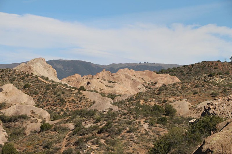
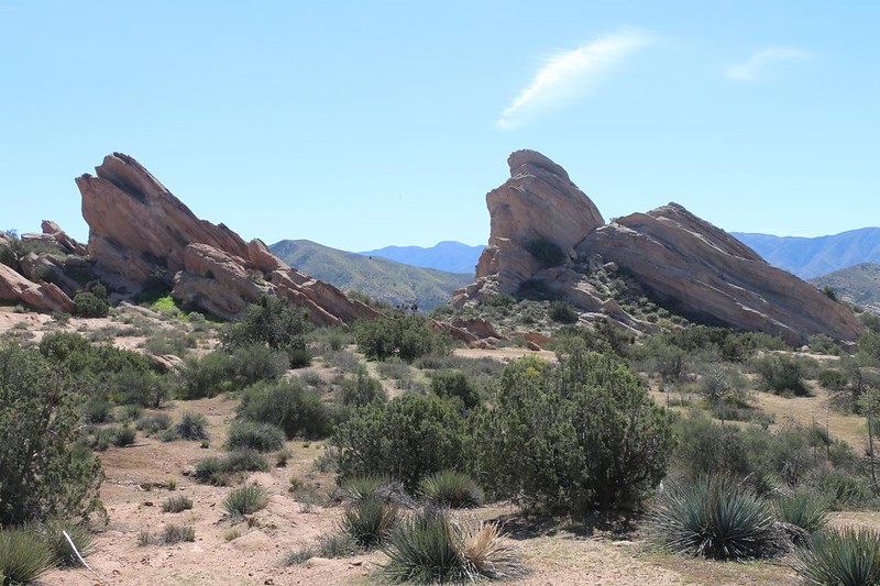
I’m still not sure which part of the hike I liked best: The beautiful poppies I’d seen earlier, or the walk through Vasquez Rocks County Park, which I entered on the northern side of Highway 14. There were all sorts of interesting sandstone formations in this park. The first section I hiked through was down in the canyon, and the walls were made of convoluted stone with countless caves and pockets. I really wanted to climb up and check them all out, but I had no time. Or maybe I temporarily forgot how old I’m getting. (I really can’t risk a fall these days, because it might affect my hiking plans!) There was also a lot of green vegetation down in the bottom of the canyon, and many plants were labelled with signage. I liked that.


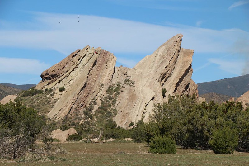
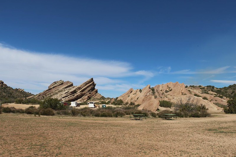
Eventually, the main canyon headed downstream to the left, but the PCT went uphill to the right. This was the day’s final climb, and the sun was hot. I trudged on. Soon enough, I got a view of the park’s main attraction: The Vasquez Rocks themselves. They were tall sandstone formations whose layers were tilted upward impressively. They towered above the wide plain. As I got closer, I saw that a young couple were climbing up to the top of one of them. I knew right away what this was all about: A chance to post a cool picture on social media! And I could understand why. These rocks were seriously fun. In fact, Vicki and I had climbed up one of them last year, after our PCT hike. We got pizza in town and decided to eat it down here in the park, then had no choice but to make the climb. And, yes, I sent photos of us to friends and family, so there you go. This is a really fun park.

I had a bit of trouble following the exact path of the PCT, as there were so many trails going everywhere, but I eventually headed over to the pepper tree where the trail angels typically leave a cache of water or some trail magic. Sadly, it was a bit too early this season and there was nothing there but empty water jugs. Oh well. Good thing I didn’t need anything. So I continued onward, taking in the sights.

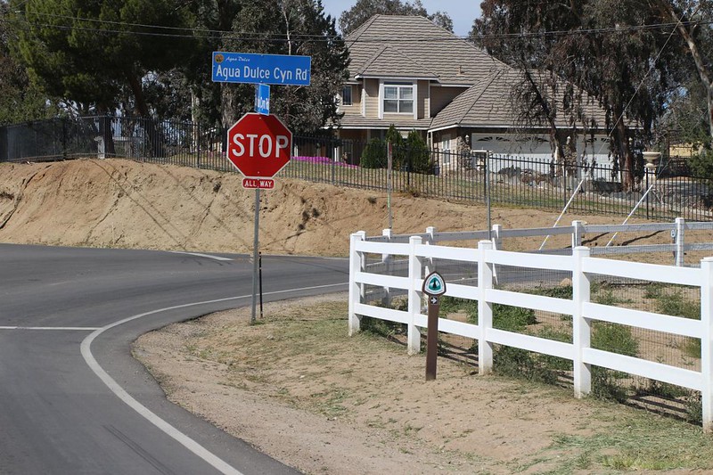
After leaving the park, the PCT continued along the side of paved roads for another mile or so on its way into the hiker-friendly town of Agua Dulce. This town marks the northern end of “PCT California Section D,” and many thru-hikers use it as a resupply stop. There is a post office to collect food and gear, and also to send out un-needed gear. The next big section consisted primarily of hiking across the Mojave Desert, so there were new conditions to be prepared for. Agua Dulce also had several restaurants, and thru-hikers are notoriously starved for calories. The town makes some decent money every Spring as the parade of backpackers goes by.

It turns out that beginning a hike at dawn results in arriving at the end quite early. I still had my trail lunch in my pack! I decided to eat in the car and head on home right away. Maybe I could beat the afternoon rush hour in Los Angeles if I hustled. So I got myself ready for a three hour drive: Snacks and food in the front, and I changed out my sweaty socks and shoes. Ahhh! That always feels good. Then I drove back to the Soledad Canyon trailhead. I unlocked my eBike and hung it on the bike rack. I had to admit that this eBike was making solo hiking much more convenient than I had anticipated.

All in all, this had been a surprisingly fun hike. I was expecting boring chaparral but instead was treated to blooming poppies, killer views, and awesome sandstone. And the best part was that this hike finished off the last ten miles of Section D, so now I had all of the first four Southern California sections in the bag. Nice! In a way, this was sad, because they were all close to San Diego, but it also meant that I’d have to concentrate more on the Sierra Nevada and NorCal sections in the future. I could handle that.
For even more photos and videos see my Flickr Page.
For a topographic map of our GPS track see my CalTopo Page.
