This was the day we visited Image Lake and the Miners Ridge Fire Lookout Tower, one of the highlights of our hiking trek in the Glacier Peak Wilderness.
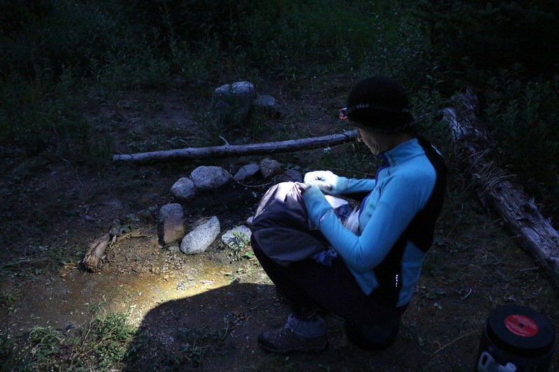
The day started out well before dawn, exactly as we’d planned. We had to climb 1800 feet over a distance of six miles, and the weather was likely to be hot. Plus, we’d be on the south side of Miners Ridge with possible sun exposure. We’ve done this sort of thing before, and we knew that if we got moving early, in the cool of the morning, Vicki would be able to crank out a lot more distance before she began overheating. So we woke up at 4:30am in the dark and packed up our gear. We ate a cold breakfast and saved some time by not cooking.
We hiked back along Miners Creek on the old trail and discovered that no other PCT hikers had stopped in the big campsite that we had avoided the night before. Oh well. We still liked our campsite better. Then we hung a right on the PCT and crossed the creek on the wooden bridge. After that, the trail began climbing in earnest.
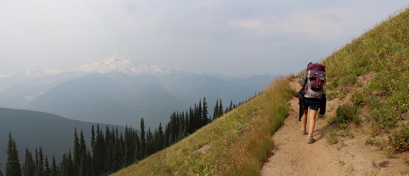
Vicki almost immediately began lagging. She doesn’t do “up” very well when there’s a lot of weight on her back. So I offered to carry a part of her pack for her. She took off the lid of her pack and attached it to the back of mine. She asked if I felt unbalanced and I replied that it was no problem as my camera was so heavy in the front that it made up for it. This was a blatant lie, of course. My camera would have had to be made out of lead to counterbalance ten pounds of extra gear sticking all the way out back there! But it was a good lie. The truth is that it didn’t slow me down very much and it certainly sped up Vicki. That counts as a “win” in my book.

The trail zig-zagged and traversed its way up the side of the valley for two miles, at a fairly steady ten percent grade or so. It was still hard work, so we paused every so often to catch a few extra breaths of air, but in general we just kept plodding onward slowly, taking baby steps as we went. We took off extra layers of clothing as both ourselves and the air grew warmer. Luckily, we were under the trees in the shade, so it was tolerable.
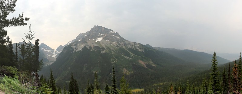
But there were no views. Just trees. Until we finally broke through and ended up on top of a small cliff. You could tell that every single person who had ever climbed this grade had stopped in this exact spot for a rest. We took off our packs and looked around. We saw the meadow far below us where we’d camped the night before. We knew that Glacier Peak was somewhere out there but we couldn’t see it as the air was far too hazy. I realized that these clouds might be the early forerunners of the rain that had been predicted to arrive tonight. We weren’t really sure as our weather info was five days old, but it seemed likely to me. Well, we had our raingear handy, and we weren’t afraid to use it.
After two miles of climbing, we left the PCT and headed west on the Miners Cabin Trail. This trail was great! It was a mile and a half long, and it stayed flat the entire time! Vicki was loving it. And continued loving it even after I gave her back the top part of her pack.
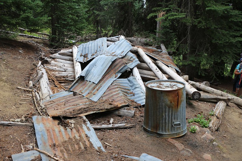
We crossed Plummer Creek and continued on to the site of the Glacier Peak Mine. Apparently this was a copper and silver mine, but was mostly just prospected back in the early 1900’s and not actually mined, primarily due to economic reasons related to the price of copper and the difficulty of mining it here. There were some old rotting cabins and rusty mining gear strewn around. I guess cleaning up their mess wasn’t economically advantageous either. The slobs. They should be ashamed of themselves. But then again, these are folks that want to tear out entire mountainsides for fun and profit, so they probably wouldn’t call this a mess at all. Let’s just call it “Progress” and leave it at that.
Video of Plummer Creek where it crosses the Miners Ridge Trail
Just beyond the mine, the Miners Ridge Trail branched off, heading uphill for two more miles. Vicki gave me the top of her pack again and we began climbing. But by this time it was getting far too hot and Vicki began drooping. Eventually, I found a wide spot in the trail and she decided that this was the perfect time for a nice nap. The flies were much better and we didn’t need the tent. So she ate some snack to get some fuel inside her body, then lay down for a rest. Time to cool off and recharge those batteries.


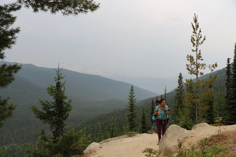
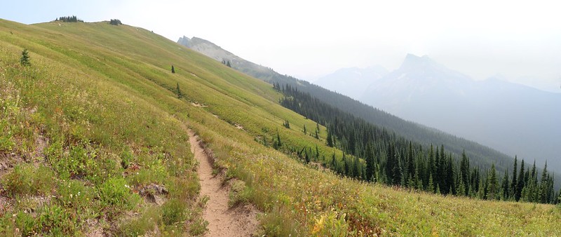
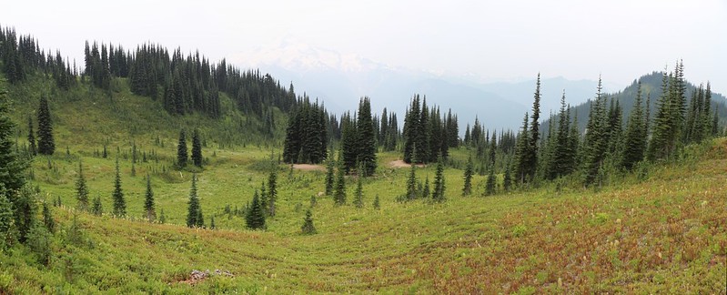
We continued onward. After a mile of climbing through the forest the trail abruptly emerged into the hazy sunlight. The grade decreased significantly and we hiked along happily through the high sloping meadows up above 6000 feet elevation. Glacier Peak was visible across the way in the haze. This was the terrain that we truly loved in the Cascades, complete with flowers and grasses and berries, high above the treeline.
Suddenly, the sky grew dark and a breeze sprang up. We felt some light sprinkles as it began to rain. The dust of the trail showed tiny spots where the drops darkened the soil. We put down our packs and put on our raingear right away. Up in the mountains the rain can come on strong and fast. We hiked along in the drizzle, but it stopped raining almost immediately and the sun broke through once again. “If you don’t like the weather in the mountains, wait five minutes” as the old saying goes. We put our raingear away and continued on.
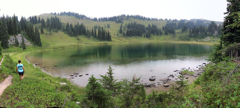
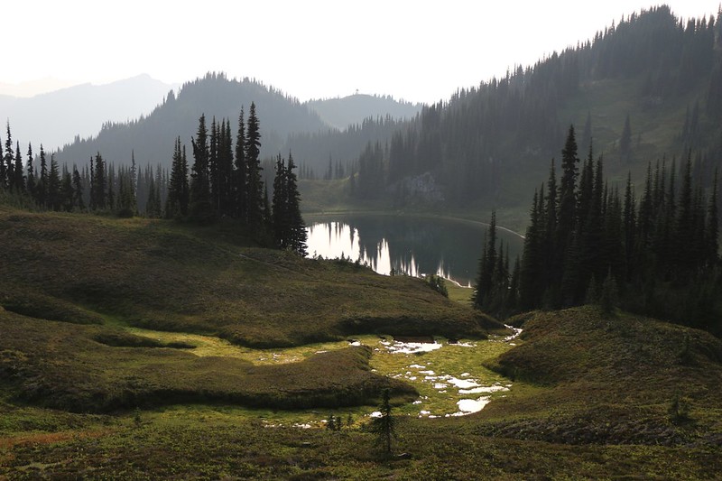
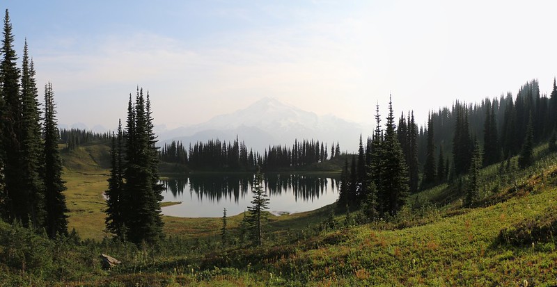
Eventually, we crested a small rise and dropped down into a wide bowl-shaped depression. We knew that Image Lake was down there somewhere. We also knew that no one was allowed to camp around the lake itself, and that the official hiker’s campsite was down the hill a bit. We arrived at a trail junction between the two places and put down our packs. We just had to check out the lake for a minute or two first, before setting up camp. We told ourselves that it might rain at any moment, and this might be our only chance to take a decent photo. The truth was that we simply wanted to see it. Right now. It felt good to walk without our heavy packs, and the sight of the lake made us feel even better. We stood in silence and viewed the peaceful scene. Lovely.
But getting camp set up before it rained was also important, so back to the packs we went. We chose a flat spot near some pine trees. We also saw a couple of fat marmots nearby. It looked like they were hoping for some new campers to arrive, as well. We vowed to give them absolutely no food, because that’s the rule when out in the wilderness, and also because we’d carried it all that way and fully intended to eat all of it. We set up the tent and got our gear inside. Once again, we emptied Vicki’s pack to use as a day-pack and placed our raingear, snacks, and the ten essentials inside it.
Then it was time to explore.
We hiked back to the south side of the lake and took photos as we wandered along the path. We were looking for a place with a “beach” as we had heard from other hikers yesterday that a bunch of people were swimming in the lake, and floating around on it using their air mattresses. Vicki decided that she, too, could use a nice bath, especially as the lake was reputed to be quite warm (rather than the usual glacier-fed ice baths that we typically camped near). Naturally, on our way to a nice spot it began to sprinkle again. It was fun to see the drops making tiny circles on the water’s surface. It didn’t last long, and Vicki stripped down to a T-shirt and panties, then waded into the lake, stepping slowly and carefully on the silty bottom. It wasn’t as warm as she’d expected. The sun wasn’t shining thanks to the rain clouds, so she only made it a short distance before getting chilled, with the lake water coming up to her thighs. Just as she was turning around to return to shore, she almost slipped on the muddy bottom. I’m ashamed to admit that I was a bit disappointed that she didn’t slide in over her head, as I was taking a video of her exploits at the time. Her facial expression and scream would have been priceless as she emerged, soaking wet and dripping, from the lake. And that’s why there’s no evidence of any kind here on this page. Sad but true.

Video of rain falling on Image Lake
After Vicki dried off and put on her shoes, we looked down Miner’s Ridge to the west and saw a fire lookout tower in the distance. This was one of the places where we had originally intended to camp, back before we changed our plan to include two layover days. The new plan called for only spending one night here at Image Lake, so if we were going to check out the fire tower it would have to be right now. And that’s what we did.
The tower was only a mile or so away, and there was an easy trail to get there. We hiked along the ridgetop, taking in views both south to Glacier Peak and north toward Canyon Lake. It was very hazy outside, so it certainly wasn’t the most optimal weather for visiting a lookout tower. We made up for it by trying to imagine the endless panorama of snow-covered peaks that we should have been seeing.


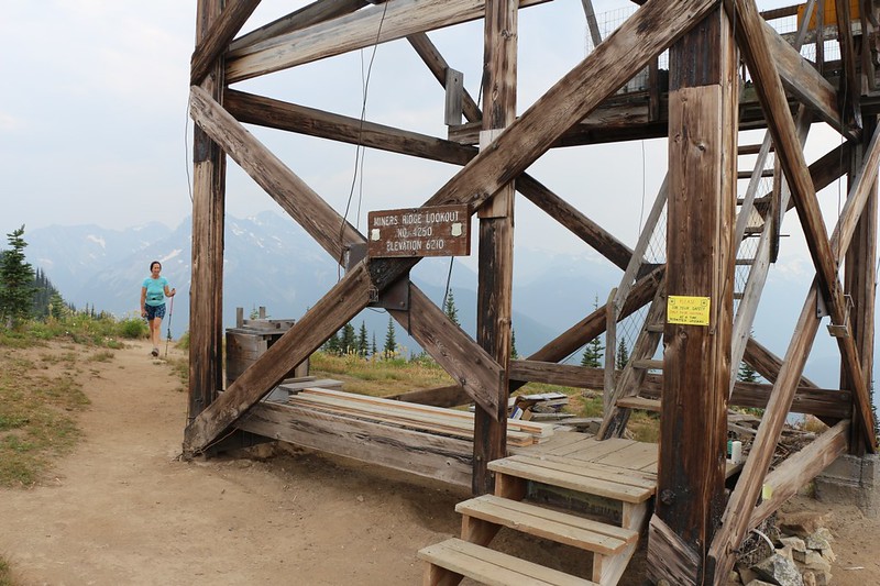
When we arrived at the tower the window covers were propped open, so we knew that someone was currently in residence. And we were certain of it when he looked down at us over the railing. He was wearing coveralls and had a can of paint in one hand and a brush in the other. I commented to him that this place probably always needed more paint, considering how exposed it is to the elements, and he agreed. Then we asked him if we might come up for a visit and he said yes, but just be careful not to touch the wet paint in one section.
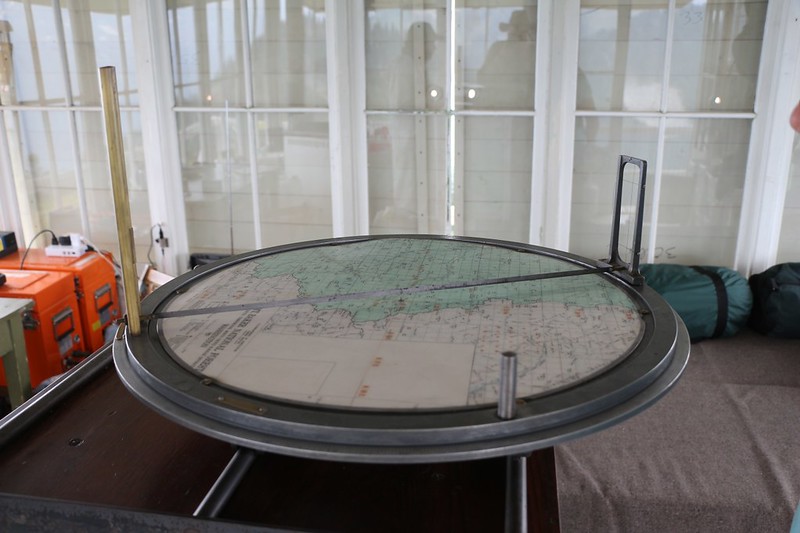
We hung out up there for awhile. He worked for the National Forest Service full-time and was only here for the summer. He showed us the directional transit, with real horse-hair cross-hairs. He showed us his buckets of food, and radio with lots of batteries. His bed was in the tower, too, so it was really nice of him to let us into his “bedroom” – a bedroom with a five-star view! He also had some recent weather info, and said that the storm we’d been expecting was still due to pass through that night, and that it would clear up afterward, with good weather for the next few days. This really cheered us up. Maybe this horrible heat wave and haziness would finally be gone. Maybe the flies would go away, too, although they hadn’t been bad all day. Besides the obvious photos, I also took a shot of the tower’s bookcase, just to see what sort of reading material there was on hand for bored people all alone on top of fire towers to read. There was “Desolation Angels” by Jack Kerouac, of course, but there were a couple of others that he recommended as they were written by similarly tower-bound authors. I vowed to look them up when I got home.

GoPro video of the interior of the tower
GoPro video panorama of the nearby views

We bid the ranger adieu and hiked back to Image Lake. We continued around the north side of the lake. We stopped at one of the tiny inlet streams and filtered two gallons of water, enough for dinner, breakfast, and tomorrow’s hike. Then we walked back down to the campground and ate some dinner. We also socialized with a couple of our new neighbors who had arrived while we were at the tower.
And then the silliest part of the day happened when a young marmot began screeching out his high-pitched cry. Now normally, one marmot is on “guard duty” and shouts out a warning to his family and friends when danger approaches. He’s braver than the others, and keeps an eye out even after spotting the danger. And he usually only emits one or maybe two screeches. But this particular fellow seemed to really enjoy his new role as Sheriff of Marmotville. Like a child with a new toy whistle, he just couldn’t help but blow it until everyone, friends and enemies alike, was sick and tired of his obnoxious racket. I tried to shut him up by walking closer and closer to him, hoping to scare him down into his hole, but he simply didn’t care. He was brave, all right. And I got a couple of good photos of him. But it didn’t shut him up. We had to endure it the entire time we ate dinner. Annoying!


Semi-focused video of an annoying marmot shouting out a warning over and over and over
We decided that an after-dinner constitutional was called for, so we grabbed the camera and headed out to follow the higher trail, staying far above the lake, hoping that somewhere along the way we would stumble upon that perfect spot to take a photo of Image Lake. The best photos on the internet showed Glacier Peak reflecting in its calm, still waters at dawn. Well, it was far too late for dawn, and it was way too hazy on this day in the late afternoon. We had a feeling that we wouldn’t be able to see Glacier Peak at all tomorrow morning if it was still raining, so this would be our only chance. We’d have to take whatever photos we could get. Plus have a pleasant evening’s hike, of course. And that’s exactly what we did. It was a nice way to end a very long and fun-filled day.

We went back to camp and made doubly sure that all of our gear was prepared for a rainy night. We didn’t want any soggy surprises to greet us when dawn arrived. We checked the tent ropes and made sure that our gear was safely under the vestibules and protected from runoff.

Then we said goodnight to our noisy marmot neighbor and he, too, went to bed in his cozy, underground home.
For a topographic map of the hike see my CalTopo Page
For LOTS more photos of the trek see my Flickr Page
 << Back to Day 4 Onward to Day 6 >>
